Hills of Britain and Ireland
OS Map of Cairn of Meadows
Height: 687m / 2254ft • Prominence: 43m / 141ft • Summit : no feature: ground SE of stile • Trip reports (hill-bagging)

Fine walk today in lovely Glen Lethnot
A quiet place.
18-Mar-22 • We travel the Spaceways • flickr
51946406603

Green Boulder Bridge
This is Glen Lethnot's slightly more secretive suspension bridge. The paths on either side quickly fade into obscurity and you only see it once you've walked so far along a pathless path. Walking over it is an interesting experience as it leans ever so slightly to one side, meaning that it feels like the bridge wants to throw you into the river. This photo was taken after we'd crossed the span and looks back at the rocky slopes of West Craig, which is covered in boulders on this side. We did eventually end up at the top of the hill but we went the long way round.
bridge angus boulders suspensionbridge glenlethnot waterofsaughs 20519064196

Glen Lethnot In August
This is the defining view of Glen Lethnot from the top of West Craig and it has to be one of the finest views in Angus. Due to its remote location, not many people seem to visit here which is both good and bad. It's good because it means I've always had this glorious scene to myself. The only reason I say it could be a bad thing is because it'd be interesting to compare my photos to those of others who have been here. With that said, I can compare this photo to the one I took from this spot www.flickr.com/photos/k-burn/16656735424/ back in April . I have to say that despite the more interesting sky and more varied colour palette of the August scene, I prefer the April view as the shadows are stronger and the view somehow manages to feel even more remote. I'll have to capture this scene again in either snowy or frosty conditions... If you want to feel like you were on this walk, a lot of it was filmed and turned into a www.youtube.com/watch?v=IU6xYFliQHM" rel="nofollow 16 minute video .
grave plaque angus valley cairn glenlethnot waterofsaughs westcraig 19922671834

Smoke On The Hills
Once you reach the end of the long, dead end road into Glen Lethnot, a track leads you further into the hills. You have to walk about two miles before the wide, glacial valley gives way to the rising slopes at the back and on the day I took this, the hot April sun was beating down on a dry and predominantly yellow landscape. As I was here by myself with no-one else around, it felt like I was walking through a Scottish desert. The only major point of interest you pass on approach to the rising hills at the back of the glen is this footbridge which spans the Water of Saughs. No paths lead away from it, although I get the feeling not many people have the confidence to walk over this bridge to begin with.
bridge river angus rapids suspensionbridge glenlethnot waterofsaughs 17092983669


OS Map
This is OS mapping. In some areas, OpenStreetMap shows more footpaths
Spatial NI has online OSNI mapping. Click "Basemap Gallery" (4 squares icon at the top).
Now would be a good time for a cup of tea.
GPX Editor
Record map clicks
Reload map
Photos
Please tag your photos and upload them to the British and Irish Mountains group on Flickr
The other photos have been geo-tagged as on or around the summit. For less busy mountains, it can be a little hit and miss.
Fine walk today in lovely Glen Lethnot
A quiet place.
18-Mar-22 • We travel the Spaceways • flickr
51946406603
Green Boulder Bridge
This is Glen Lethnot's slightly more secretive suspension bridge. The paths on either side quickly fade into obscurity and you only see it once you've walked so far along a pathless path. Walking over it is an interesting experience as it leans ever so slightly to one side, meaning that it feels like the bridge wants to throw you into the river. This photo was taken after we'd crossed the span and looks back at the rocky slopes of West Craig, which is covered in boulders on this side. We did eventually end up at the top of the hill but we went the long way round.
bridge angus boulders suspensionbridge glenlethnot waterofsaughs 20519064196
Glen Lethnot In August
This is the defining view of Glen Lethnot from the top of West Craig and it has to be one of the finest views in Angus. Due to its remote location, not many people seem to visit here which is both good and bad. It's good because it means I've always had this glorious scene to myself. The only reason I say it could be a bad thing is because it'd be interesting to compare my photos to those of others who have been here. With that said, I can compare this photo to the one I took from this spot www.flickr.com/photos/k-burn/16656735424/ back in April . I have to say that despite the more interesting sky and more varied colour palette of the August scene, I prefer the April view as the shadows are stronger and the view somehow manages to feel even more remote. I'll have to capture this scene again in either snowy or frosty conditions... If you want to feel like you were on this walk, a lot of it was filmed and turned into a www.youtube.com/watch?v=IU6xYFliQHM" rel="nofollow 16 minute video .
grave plaque angus valley cairn glenlethnot waterofsaughs westcraig 19922671834
Smoke On The Hills
Once you reach the end of the long, dead end road into Glen Lethnot, a track leads you further into the hills. You have to walk about two miles before the wide, glacial valley gives way to the rising slopes at the back and on the day I took this, the hot April sun was beating down on a dry and predominantly yellow landscape. As I was here by myself with no-one else around, it felt like I was walking through a Scottish desert. The only major point of interest you pass on approach to the rising hills at the back of the glen is this footbridge which spans the Water of Saughs. No paths lead away from it, although I get the feeling not many people have the confidence to walk over this bridge to begin with.
bridge river angus rapids suspensionbridge glenlethnot waterofsaughs 17092983669


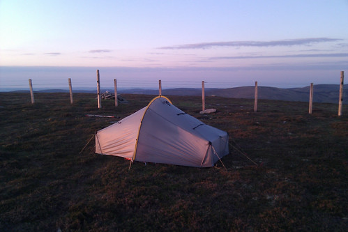
Scarp 1 at sunrise
The summit cairn marking the top of Cruys is visible to the left of the tent behind the fence
28-May-12 • Nick Bramhall • flickr
7303150978
Videos
None found
Notes
- Data: Database of British and Irish Hills v18.2
- Maps: We use OS mapping for England, Scotland, Wales, and the Isle of Man. Sadly, Channel Islands, Northern (OSNI) and Southern Ireland (OSI) mapping isn't available online, so we use Openstreetmap.