Hills of Britain and Ireland
OS Map of Stybarrow Dodd
Height: 844m / 2768ft • Prominence: 69m / 226ft • Summit : no feature: ground 15m SE of cairn • Trip reports (hill-bagging)

Hart Side
It's a long walk to the top.. but at least the going is easy, if a little squelchy. Panorama stitched from two shots at 14mm, taken on the way up to Hart Side in the Lake District, UK
21-Oct-24 • flindersan • flickr
panasonicgx9 microsoftice 54337643405

Stybarrow Dodd and the Helvellyn range from Great Dodd.
13-Sep-24 • colin9007 • flickr
cumbria lake district clough head great dodd watsons cumberland westmorland england uk 53992913910

Great Dodd, 2,807 feet above sea level.
13-Sep-24 • colin9007 • flickr
cumbria lake district clough head great dodd watsons cumberland westmorland england uk 53992487441

A Path Up Stybarrow Dodd
With Blencathra on the left (in the distance).
10-Aug-24 • Paul Austin Murphy • flickr
53917655418


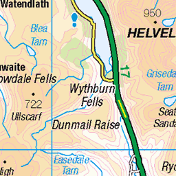
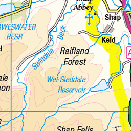
OS Map
This is OS mapping. In some areas, OpenStreetMap shows more footpaths
Spatial NI has online OSNI mapping. Click "Basemap Gallery" (4 squares icon at the top).
Now would be a good time for a cup of tea.


GPX Editor
Record map clicks
Reload map
Photos
Please tag your photos and upload them to the British and Irish Mountains group on Flickr
The other photos have been geo-tagged as on or around the summit. For less busy mountains, it can be a little hit and miss.
Hart Side
It's a long walk to the top.. but at least the going is easy, if a little squelchy. Panorama stitched from two shots at 14mm, taken on the way up to Hart Side in the Lake District, UK
21-Oct-24 • flindersan • flickr
panasonicgx9 microsoftice 54337643405
Stybarrow Dodd and the Helvellyn range from Great Dodd.
13-Sep-24 • colin9007 • flickr
cumbria lake district clough head great dodd watsons cumberland westmorland england uk 53992913910
Great Dodd, 2,807 feet above sea level.
13-Sep-24 • colin9007 • flickr
cumbria lake district clough head great dodd watsons cumberland westmorland england uk 53992487441
A Path Up Stybarrow Dodd
With Blencathra on the left (in the distance).
10-Aug-24 • Paul Austin Murphy • flickr
53917655418

Stybarrow Dodd, Aug. 2023
19-Aug-23 • Great Uncle David • flickr
mountains cumbria lakedistrict england stybarrowdodd 53168089934

Stybarrow Dodd, summit and cairn, Aug. 2023
19-Aug-23 • Great Uncle David • flickr
mountains cumbria lakedistrict england stybarrowdodd 53168373493

Stybarrow Dodd, Aug. 2023
19-Aug-23 • Great Uncle David • flickr
mountains cumbria lakedistrict england stybarrowdodd 53168372943

Great Dodd, windshelter, Aug. 2023
19-Aug-23 • Great Uncle David • flickr
mountains cumbria lakedistrict england greatdodd 53167299642
Videos
This is a solo Lake District hike taking in the 5 Wainwrights Great Dodd, Watson's Dodd, Stybarrow Dodd, Raise and Hart Side in ...
Amaizng hike up to Stybarrow Dodd in Lake District with dip in the cold water of the Thirlmere infinity pool . I hope you will enjoy ...
A day in the lakes ticking off some Wainwrights.
A linear route from Wanthwaite to Glenridding taking in Clough Head and the Dodds.
Hiking the Dodds in 45 Seconds Don't forget to... Like & Subscribe if you want to see more!
Notes
- Data: Database of British and Irish Hills v18.2
- Maps: We use OS mapping for England, Scotland, Wales, and the Isle of Man. Sadly, Channel Islands, Northern (OSNI) and Southern Ireland (OSI) mapping isn't available online, so we use Openstreetmap.