Hills of Britain and Ireland
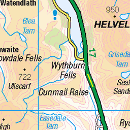
OS Map of Raise
Height: 883m / 2896ft • Prominence: 92m / 302ft • Summit : cairn on rock • Trip reports (hill-bagging)


A Path Up Stybarrow Dodd
With Blencathra on the left (in the distance).
10-Aug-24 • Paul Austin Murphy • flickr
53917655418


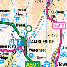
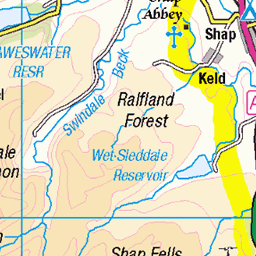
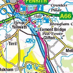
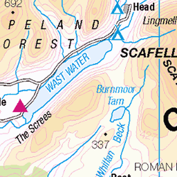
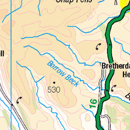
OS Map
This is OS mapping. In some areas, OpenStreetMap shows more footpaths
Spatial NI has online OSNI mapping. Click "Basemap Gallery" (4 squares icon at the top).
Now would be a good time for a cup of tea.


GPX Editor
Record map clicks
Reload map
Photos
Please tag your photos and upload them to the British and Irish Mountains group on Flickr
The other photos have been geo-tagged as on or around the summit. For less busy mountains, it can be a little hit and miss.
A Path Up Stybarrow Dodd
With Blencathra on the left (in the distance).
10-Aug-24 • Paul Austin Murphy • flickr
53917655418

Catstye Cam and White Side
Catstye Cam is the conical hill on the left. White Side is the long ridge with snow on top.
26-Jan-24 • Paul Austin Murphy • flickr
53495356979


Stybarrow Dodd, Aug. 2023
19-Aug-23 • Great Uncle David • flickr
mountains cumbria lakedistrict england stybarrowdodd 53168089934

Stybarrow Dodd, summit and cairn, Aug. 2023
19-Aug-23 • Great Uncle David • flickr
mountains cumbria lakedistrict england stybarrowdodd 53168373493

2520 Raise
30-May-18 • Dugswell2 • flickr
raise p91tump simm hewitt nuttall wainwright birkett synge fellranger subhump buxtonlewis bridge 43565137981

2520 Raise a
YHA Helvellyn to Birkhouse Moor to Catstye Cam to Helvellyn to Helvellyn Lower Man to Browncove Crags to White Side to Raise to Stand to Sheffield Pike to Heron Pike and then finally Glenridding Dodd before heading back up the road to YHA Helvellyn. Name:Raise Hill number:2520 Height:883m / 2897ft Parent (Ma):2515 Helvellyn RHB Section:34C: Lake District - Eastern Fells Nuttall/Wainwright area:Lake District - Eastern Fells County/UA:Cumbria (CoU) Catchment:Derwent (Workington), Eden (Carlisle) Watershed:Solway Firth Class:Simm, Hewitt, Nuttall, Wainwright, Birkett, Synge, Fellranger, Subhump, Buxton & Lewis, Bridge Grid ref:NY 34282 17415 Summit feature:cairn on rock Drop:91m Col:792m NY338161
30-May-18 • Dugswell2 • flickr
raise p91tump simm hewitt nuttall wainwright birkett synge fellranger subhump buxtonlewis bridge 43518331142

2520 Raise b
30-May-18 • Dugswell2 • flickr
raise p91tump simm hewitt nuttall wainwright birkett synge fellranger subhump buxtonlewis bridge 41756964030

2520 Raise c
30-May-18 • Dugswell2 • flickr
raise p91tump simm hewitt nuttall wainwright birkett synge fellranger subhump buxtonlewis bridge 29693830958

2520 Raise d
30-May-18 • Dugswell2 • flickr
raise p91tump simm hewitt nuttall wainwright birkett synge fellranger subhump buxtonlewis bridge 42659617555
Videos
A cracking day out above the far Eastern Fells with Tracey and Billy... Rampsgill Head is a fell standing to the west of Haweswater ...
A slow 360 degree panorama from the summit of High Raise (High White Stones) in the central fells region of the English Lake ...
After taking a WRONG Turn, JD bags 2 more Wainwrights. Starting from Legburthwaite near the village hall, the first is White Side ...
High Raise, Sergeant Man round from near Easdale and Grasmere. starting aside the A591 and ascending up to Dead Pike..on to ...
A circular walk from Haweswater in the Lake District going over 4 Wainwright Fells. The walk starts from Mardale Head car park ...
Notes
- Data: Database of British and Irish Hills v18.2
- Maps: We use OS mapping for England, Scotland, Wales, and the Isle of Man. Sadly, Channel Islands, Northern (OSNI) and Southern Ireland (OSI) mapping isn't available online, so we use Openstreetmap.