Hills of Britain and Ireland
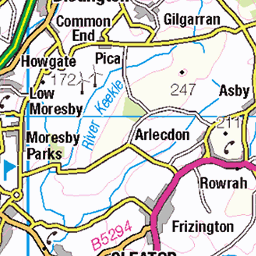
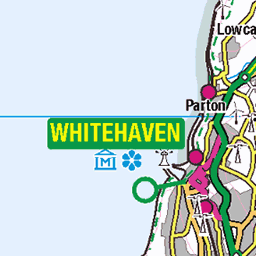
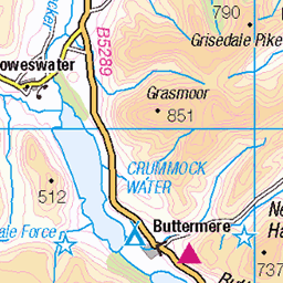
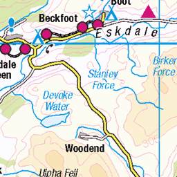
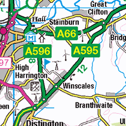
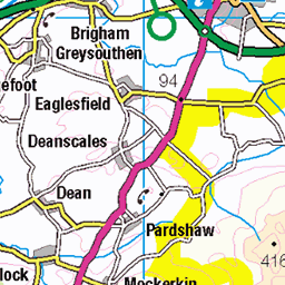
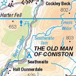
OS Map of Cold Fell
Height: 293m / 961ft • Prominence: 83m / 272ft • Summit : single stone on small boulder • Trip reports (hill-bagging)


Calder Bridge Mountain biking
13-Feb-24 • brian.phillips57 • flickr
seascale england unitedkingdom 53697179127

England 2023 10-043
OLYMPUS DIGITAL CAMERA
16-Jun-23 • stollenvernichter • flickr
haile copelanddistrict england motorrad tour motorradtour 53038567788


Monks or Mattys?
Monks Bridge on the OS map, Matty Benn's Bridge according to locals says Wainwright in his Lake District guide. Spanning the River Calder south of Ennerdale Bridge, It's an ancient packhorse bridge giving testament to a bygone era. www.visitcumbria.com/wc/monks-bridge/" rel="noreferrer nofollow www.visitcumbria.com/wc/monks-bridge/
30-Aug-17 • odell_rd3 • flickr
lakedistrict packhorsebridge monksormattys rivercalder fence 53916545775
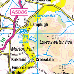
OS Map
This is OS mapping. In some areas, OpenStreetMap shows more footpaths
Spatial NI has online OSNI mapping. Click "Basemap Gallery" (4 squares icon at the top).
Now would be a good time for a cup of tea.


GPX Editor
Record map clicks
Reload map
Photos
Please tag your photos and upload them to the British and Irish Mountains group on Flickr
The other photos have been geo-tagged as on or around the summit. For less busy mountains, it can be a little hit and miss.
Calder Bridge Mountain biking
13-Feb-24 • brian.phillips57 • flickr
seascale england unitedkingdom 53697179127
England 2023 10-043
OLYMPUS DIGITAL CAMERA
16-Jun-23 • stollenvernichter • flickr
haile copelanddistrict england motorrad tour motorradtour 53038567788
Monks or Mattys?
Monks Bridge on the OS map, Matty Benn's Bridge according to locals says Wainwright in his Lake District guide. Spanning the River Calder south of Ennerdale Bridge, It's an ancient packhorse bridge giving testament to a bygone era. www.visitcumbria.com/wc/monks-bridge/" rel="noreferrer nofollow www.visitcumbria.com/wc/monks-bridge/
30-Aug-17 • odell_rd3 • flickr
lakedistrict packhorsebridge monksormattys rivercalder fence 53916545775
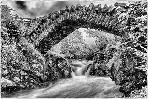
Monk's Bridge
A fabulous packhorse bridge, with some romantic stories. Bit scary to cross though - it's a long drop off the side!
15-Aug-17 • Nick Thorne, Bodian Photography • flickr
geographicalfeatures england bridge bynickthorne cumbria bybodianphotography structures flickr monksbridge themed 2017 photographer river movement ennerdale location year lakedistrict blackwhite 36367540810


Videos
Please take care when driving over Cold Fell. Sheep, Cattle and Horses roam the common. This video was shot, while driving at ...
A steep walk up Kirk Fell (802m) from Wasdale Head (over 700m of ascent) Cold and windy especially on the tops but exhilarating ...
GPX Download Of Route - https://drive.google.com/file/d/14JQTJf4IKpQGJpoYSjtIMjpnpTaS79TZ/view?usp=drivesdk Joss Naylor ...
This is a solo Lake District hike taking in the 3 Wainwrights Grike, Crag Fell and Lank Rigg in the Lake District If you enjoyed ...
Notes
- Data: Database of British and Irish Hills v18.2
- Maps: We use OS mapping for England, Scotland, Wales, and the Isle of Man. Sadly, Channel Islands, Northern (OSNI) and Southern Ireland (OSI) mapping isn't available online, so we use Openstreetmap.