Hills of Britain and Ireland
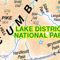
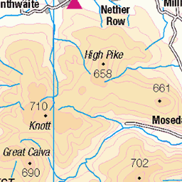
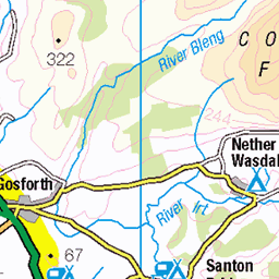
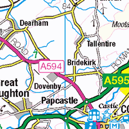
OS Map of Grange Fell (Brund Fell)
Height: 417m / 1369ft • Prominence: 42m / 138ft • Summit : cairn on rock tor • Trip reports (hill-bagging)

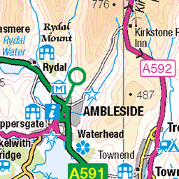
Lakeland Walk
Watendlath near Keswick
02-Apr-25 • Tony Shertila • flickr
england watendlath ashness britain copyright©2025tonysherratt cumbria europe keswick lakedistrict 20250402132656 path track road trees mountains blackandwhite monotone bw hedge 54441541132


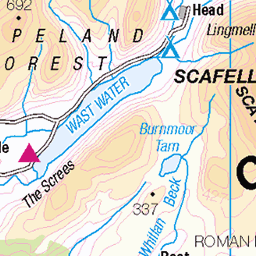
24LAK203 Common toad, between Rosthwaite and Stonethwaite
Bufo bufo Crapaud commun / Erdkröte
02-Sep-24 • bentolley1 • flickr
england cumbria lakedistrict borrowdale nature wildlife animal amphibian toad 54403127176

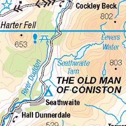
OS Map
This is OS mapping. In some areas, OpenStreetMap shows more footpaths
Spatial NI has online OSNI mapping. Click "Basemap Gallery" (4 squares icon at the top).
Now would be a good time for a cup of tea.


GPX Editor
Record map clicks
Reload map
Photos
Please tag your photos and upload them to the British and Irish Mountains group on Flickr
The other photos have been geo-tagged as on or around the summit. For less busy mountains, it can be a little hit and miss.
Lakeland Walk
Watendlath near Keswick
02-Apr-25 • Tony Shertila • flickr
england watendlath ashness britain copyright©2025tonysherratt cumbria europe keswick lakedistrict 20250402132656 path track road trees mountains blackandwhite monotone bw hedge 54441541132
24LAK203 Common toad, between Rosthwaite and Stonethwaite
Bufo bufo Crapaud commun / Erdkröte
02-Sep-24 • bentolley1 • flickr
england cumbria lakedistrict borrowdale nature wildlife animal amphibian toad 54403127176


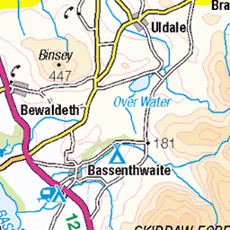
Rosthwaite from Castle Crag.
Nearing the top of Castle Crag the path winds through the spoil from the old slate quarries. Just below the plume of smoke from Rosthwaite is the café that was mentioned in a previous picture, the Flock In. Just beyond this ancient lake bed Borrowdale splits into two valleys. Straight ahead is Langstrath dominated by the steep cliffs of Eagle Crag. To the right the road leads to Honister Pass and Buttermere.
28-Jan-09 • greengrocer48 • flickr
castlecrag rosthwaite eaglecrag langstrath borrowdale cumbria england lakedistrict village 54344050726
Videos
We're back! In a first Lakeland walk after lockdown, Neil visits Grange Fell, in glorious Borrowdale, and visits the three different ...
Borrowdale Valley is Wainwright's FAVOURITE square mile in THE LAKE DISTRICT See more Lake District walks in the ...
A Wainwright Walk up Grange Fell above Borrowdale. Beautiful weather for this trip, which includes a visit to the Bowder Stone.
This 12km walk is a low level hike taking in Grange Fell and Castle Crag (the smallest of the Wainwrights). Starting near the ...
Grangefell #wainwrights #lakedistrict #walkingthewainwrights #wainwrightwalks In this film Andy Beck takes a route over Grange ...
Notes
- Data: Database of British and Irish Hills v18.2
- Maps: We use OS mapping for England, Scotland, Wales, and the Isle of Man. Sadly, Channel Islands, Northern (OSNI) and Southern Ireland (OSI) mapping isn't available online, so we use Openstreetmap.