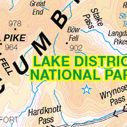
Hills of Britain and Ireland
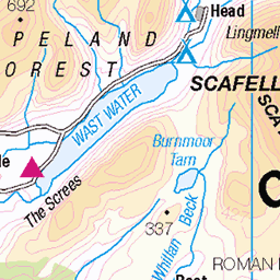
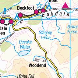
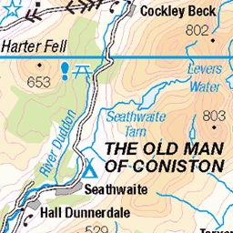
OS Map of Seathwaite Fell (Great Slack - Seathwaite Fell)
Height: 631m / 2070ft • Prominence: 31m / 102ft • Summit : cairn on rock • Trip reports (hill-bagging)

photo
03-Dec-24 • Marie-Laure Even • flickr
hike landscape winter lakedistrict greatgablestyheadtarnhike cumbria olympusem5markii wild marielaureeven tree travel cloud wilderness 2024 lakedistrictnationalpark nature england europe uk mountain arbre fjall hiver montagne nuage paysage royaumeuni unitedkingdom voyage гора природа 54282004414

Blencathra.
03-Dec-24 • Marie-Laure Even • flickr
hike landscape winter lakedistrict greatgablestyheadtarnhike cumbria snow olympusem5markii wild marielaureeven tree travel blencathra wilderness 2024 lakedistrictnationalpark nature england europe uk mountain arbre fjall hiver montagne neige paysage royaumeuni unitedkingdom voyage гора природа cloud frost 54234564768

photo
03-Dec-24 • Marie-Laure Even • flickr
hike landscape winter lakedistrict greatgablestyheadtarnhike frost cumbria lake styheadtarn wild marielaureeven olympusem5markii travel cloud wilderness 2024 lakedistrictnationalpark nature england europe uk mountain fjall hiver lac montagne nuage paysage royaumeuni unitedkingdom voyage гора природа 54314928212

Stockley Bridge, Lake District
The old packhorse bridge of Stockley Bridge located at the head of Borrowdale where the path forks to head up to either Styhead Pass or Allen Crags Gill.
water england outdoors footpath lakedistrict countryside view valley bridge nationalpark mountains cumbria stockley landscape 54090994446

From Seathwaite Fell, Lake District
Looking down Gains from just below Seathwaite Fell. Before you is Borrowdale, Castle Crag, Derwentwater, Keswick and looking up to Skiddaw.
england outdoors derwent keswick lakedistrict countryside cumbria view valley nationalpark mountains borrowdale skiddaw landscape fells 54090949036

Great Gable, Kirk Fell and Pillar
You can only see the crags of Great Gable on the left. Kirk Fell is in the middle, and Pillar is the higher hill beyond that. The photo was taken on Green Gable, heading down to Windy Gap.
14-Aug-24 • Paul Austin Murphy • flickr
53933191845
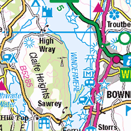
OS Map
This is OS mapping. In some areas, OpenStreetMap shows more footpaths
Spatial NI has online OSNI mapping. Click "Basemap Gallery" (4 squares icon at the top).
Now would be a good time for a cup of tea.


GPX Editor
Record map clicks
Reload map
Photos
Please tag your photos and upload them to the British and Irish Mountains group on Flickr
The other photos have been geo-tagged as on or around the summit. For less busy mountains, it can be a little hit and miss.
photo
03-Dec-24 • Marie-Laure Even • flickr
hike landscape winter lakedistrict greatgablestyheadtarnhike cumbria olympusem5markii wild marielaureeven tree travel cloud wilderness 2024 lakedistrictnationalpark nature england europe uk mountain arbre fjall hiver montagne nuage paysage royaumeuni unitedkingdom voyage гора природа 54282004414
Blencathra.
03-Dec-24 • Marie-Laure Even • flickr
hike landscape winter lakedistrict greatgablestyheadtarnhike cumbria snow olympusem5markii wild marielaureeven tree travel blencathra wilderness 2024 lakedistrictnationalpark nature england europe uk mountain arbre fjall hiver montagne neige paysage royaumeuni unitedkingdom voyage гора природа cloud frost 54234564768
photo
03-Dec-24 • Marie-Laure Even • flickr
hike landscape winter lakedistrict greatgablestyheadtarnhike frost cumbria lake styheadtarn wild marielaureeven olympusem5markii travel cloud wilderness 2024 lakedistrictnationalpark nature england europe uk mountain fjall hiver lac montagne nuage paysage royaumeuni unitedkingdom voyage гора природа 54314928212
Stockley Bridge, Lake District
The old packhorse bridge of Stockley Bridge located at the head of Borrowdale where the path forks to head up to either Styhead Pass or Allen Crags Gill.
water england outdoors footpath lakedistrict countryside view valley bridge nationalpark mountains cumbria stockley landscape 54090994446
From Seathwaite Fell, Lake District
Looking down Gains from just below Seathwaite Fell. Before you is Borrowdale, Castle Crag, Derwentwater, Keswick and looking up to Skiddaw.
england outdoors derwent keswick lakedistrict countryside cumbria view valley nationalpark mountains borrowdale skiddaw landscape fells 54090949036
Great Gable, Kirk Fell and Pillar
You can only see the crags of Great Gable on the left. Kirk Fell is in the middle, and Pillar is the higher hill beyond that. The photo was taken on Green Gable, heading down to Windy Gap.
14-Aug-24 • Paul Austin Murphy • flickr
53933191845

The Scafell Massif
Scafell Pike (left), Sca Fell (centre), and Lingmell (the lower hill).
14-Aug-24 • Paul Austin Murphy • flickr
53926176123


photo
16-Jun-17 • Marie-Laure Even • flickr
hike landscape styheadsprinklingtarnwalk nikond7100 unitedkingdom summer wild marielaureeven june travel cloud nature 2017 england lakedistrict wilderness europe uk mountain eté fjall montagne nuage paysage royaumeuni voyage гора природа allerdale 54134680908
Videos
I challenged myself to climb all 214 wainwright's in my 60th year, i.e. between my 59th and 60th birthdays. This video see me ...
I capture some wintry scenes on a walk circumnavigating Seathwaite Fell at the far end of the Borrowdale Valley. Starting at ...
A slow climb up Seathwaite Fell and we're treated to a very pleasant surprise as we peer over the top to see Seathwaite Tarn ...
Back in the Lake District and enjoyed a wonderful night on Seathwaite Fell, after a good ascent via Styhead & Sprinkling Tarns, ...
Notes
- Data: Database of British and Irish Hills v18.2
- Maps: We use OS mapping for England, Scotland, Wales, and the Isle of Man. Sadly, Channel Islands, Northern (OSNI) and Southern Ireland (OSI) mapping isn't available online, so we use Openstreetmap.