Hills of Britain and Ireland
OS Map of Base Brown

photo
03-Dec-24 • Marie-Laure Even • flickr
hike landscape winter lakedistrict greatgablestyheadtarnhike cumbria olympusem5markii wild marielaureeven tree travel cloud wilderness 2024 lakedistrictnationalpark nature england europe uk mountain arbre fjall hiver montagne nuage paysage royaumeuni unitedkingdom voyage гора природа 54282004414

Blencathra.
03-Dec-24 • Marie-Laure Even • flickr
hike landscape winter lakedistrict greatgablestyheadtarnhike cumbria snow olympusem5markii wild marielaureeven tree travel blencathra wilderness 2024 lakedistrictnationalpark nature england europe uk mountain arbre fjall hiver montagne neige paysage royaumeuni unitedkingdom voyage гора природа cloud frost 54234564768

photo
03-Dec-24 • Marie-Laure Even • flickr
hike landscape winter lakedistrict greatgablestyheadtarnhike frost cumbria lake styheadtarn wild marielaureeven olympusem5markii travel cloud wilderness 2024 lakedistrictnationalpark nature england europe uk mountain fjall hiver lac montagne nuage paysage royaumeuni unitedkingdom voyage гора природа 54314928212

Sour Milk Gill Bridge waving
The mountain is Base Brown and the waterfalls are top right....quite a steep walk up to those. From left - Catherine, Paul S, Phil, Carole, Val O, Dawn, Liz.
13-Oct-24 • Jackie & Dennis • flickr
shdrc yhaweekend borrowdale 54193280644

Looking back
...part way up the climb to the waterfalls.
13-Oct-24 • Jackie & Dennis • flickr
shdrc yhaweekend borrowdale 54193259028

Sour Milk Gill
The waterfalls, plus a few people :-) (Liz (by the hat), Carole (by the rucksack) & Paul S (by the trousers)) There is also a slight bit of rucksack of ANO (guessing Val O).
13-Oct-24 • Jackie & Dennis • flickr
shdrc yhaweekend borrowdale 54193193496
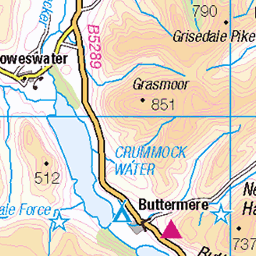
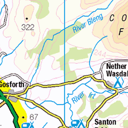
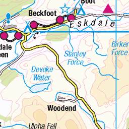
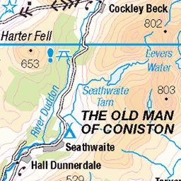
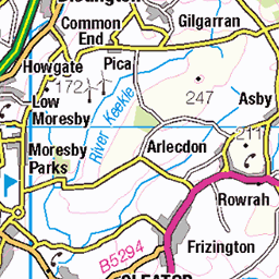
OS Map
This is OS mapping. In some areas, OpenStreetMap shows more footpaths
Spatial NI has online OSNI mapping. Click "Basemap Gallery" (4 squares icon at the top).
Now would be a good time for a cup of tea.


GPX Editor
Record map clicks
Reload map
Photos
Please tag your photos and upload them to the British and Irish Mountains group on Flickr
The other photos have been geo-tagged as on or around the summit. For less busy mountains, it can be a little hit and miss.
photo
03-Dec-24 • Marie-Laure Even • flickr
hike landscape winter lakedistrict greatgablestyheadtarnhike cumbria olympusem5markii wild marielaureeven tree travel cloud wilderness 2024 lakedistrictnationalpark nature england europe uk mountain arbre fjall hiver montagne nuage paysage royaumeuni unitedkingdom voyage гора природа 54282004414
Blencathra.
03-Dec-24 • Marie-Laure Even • flickr
hike landscape winter lakedistrict greatgablestyheadtarnhike cumbria snow olympusem5markii wild marielaureeven tree travel blencathra wilderness 2024 lakedistrictnationalpark nature england europe uk mountain arbre fjall hiver montagne neige paysage royaumeuni unitedkingdom voyage гора природа cloud frost 54234564768
photo
03-Dec-24 • Marie-Laure Even • flickr
hike landscape winter lakedistrict greatgablestyheadtarnhike frost cumbria lake styheadtarn wild marielaureeven olympusem5markii travel cloud wilderness 2024 lakedistrictnationalpark nature england europe uk mountain fjall hiver lac montagne nuage paysage royaumeuni unitedkingdom voyage гора природа 54314928212
Sour Milk Gill Bridge waving
The mountain is Base Brown and the waterfalls are top right....quite a steep walk up to those. From left - Catherine, Paul S, Phil, Carole, Val O, Dawn, Liz.
13-Oct-24 • Jackie & Dennis • flickr
shdrc yhaweekend borrowdale 54193280644
Looking back
...part way up the climb to the waterfalls.
13-Oct-24 • Jackie & Dennis • flickr
shdrc yhaweekend borrowdale 54193259028
Sour Milk Gill
The waterfalls, plus a few people :-) (Liz (by the hat), Carole (by the rucksack) & Paul S (by the trousers)) There is also a slight bit of rucksack of ANO (guessing Val O).
13-Oct-24 • Jackie & Dennis • flickr
shdrc yhaweekend borrowdale 54193193496

Sour Milk Gill - group shot
From left = Liz, Phil, Catherine, Dawn, Val O, Carole and Paul S Base Brown, our first summit behind.
13-Oct-24 • Jackie & Dennis • flickr
shdrc yhaweekend borrowdale 54195475005

Looking over Sour Milk Gill
There is more than one Sour Mill Gill (sometimes different spellings) - the name might be because as it cascades down over rocks it looks like milk.
13-Oct-24 • Jackie & Dennis • flickr
yhaweekend borrowdale shdrc 54195096656

Shooting everyone on Green Gable
Including the passer by who kindly agreed to take shot with Carole's mobile. From left - Catherine, Val O, Phil, Carole, Paul S and Dawn. I was behind, I don't know where Liz was.
13-Oct-24 • Jackie & Dennis • flickr
shdrc yhaweekend borrowdale 54195585179

Patting Dawn on the head
Or so it appears, I can't recall what was being said...but Carole's arm is perfectly placed. On Grey Knotts. From left - Phil, Paul S, Val O, Catherine, Carole, Dawn, Liz
13-Oct-24 • Jackie & Dennis • flickr
shdrc yhaweekend borrowdale 54194422662

2439 Base Brown
20-Apr-18 • Dugswell2 • flickr
basebrown p38 tump simm hewitt nuttall wainwright birkett synge fellranger buxtonlewis bridge 41612644272

2439 Base Brown a
Warm and sunny walk after parking in Seathwaite. A quick up and down the Sour Milk Gill path. Name:Base Brown Hill number:2439 Height:646m / 2119ft Parent (Ma):2367 Great Gable RHB Section:34B: Lake District - Central & Western Fells Nuttall/Wainwright area:Lake District - Western Fells County/UA:Cumbria (CoU) Catchment:Derwent (Workington) Class:Simm, Hewitt, Nuttall, Wainwright, Birkett, Synge, Fellranger, Buxton & Lewis, Bridge Grid ref:NY 22516 11464 Summit feature:cairn Drop:38m Col:608m NY221111
20-Apr-18 • Dugswell2 • flickr
basebrown p38 tump simm hewitt nuttall wainwright birkett synge fellranger buxtonlewis bridge 27783292238

2439 Base Brown b
20-Apr-18 • Dugswell2 • flickr
basebrown p38 tump simm hewitt nuttall wainwright birkett synge fellranger buxtonlewis bridge 26784225327
Videos
We're back! On the last August Bank Holiday of 2023, Neil pays a visit to the hidden gem of Seathwaite and, from there, embarks ...
A walk in the Lake District up to two Wainwright Fells, Base Brown (664m) and Green Gable (801m) The walk starts from ...
GPX Download Of Track.. https://drive.google.com/file/d/14DGSXBm93E7vgPxpZyuW4bRLdz9aHaEp/view?usp=drivesdk The ...
Three Wainwrights on a sunny day out in the Western Fells. https://www.youtube.com/@TonysTrails?sub_confirmation=1 ...
Hike to the Hanging Stone , been some rock fall just under the stone , then up to Base Brown , Seathwaite , Borrowdale. Cumbria .
Notes
- Data: Database of British and Irish Hills v18.2
- Maps: We use OS mapping for England, Scotland, Wales, and the Isle of Man. Sadly, Channel Islands, Northern (OSNI) and Southern Ireland (OSI) mapping isn't available online, so we use Openstreetmap.