Hills of Britain and Ireland
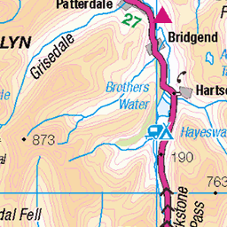
OS Map of Ullock Pike

Dodd Hill 1
Dodd Hill lies near to Bassenthwaite Lake. This was shot from the path leading to St Bega's Church.
05-Mar-25 • Bill Cumming • flickr
cumbria lakedistrict bassenthwaite doddhill 2025 54371710471

IMG_5283_edited-1
We stayed at a hotel on the shores of Bassenthwaite Lake, north of Keswick in the Lake District. In the morning there was a layer of fog lingering on the lake. As we walked down to the shore we passed this solitary tree which was backlit by the sun just starting to shine through the fog.
18-Nov-24 • ianmoran973 • flickr
54217348900


photo
Heading up to Ullock Pike.
22-Sep-24 • Steve Hodgson Photos • flickr
cumbria lakedistrict 54016851582

photo
Hike up Ullock pike, Long side and Carl side. View to Skiddaw
22-Sep-24 • Steve Hodgson Photos • flickr
skiddaw lakedistrict cumbria 54017980233

photo
Hike up Ullock pike, Long side and Carl side. View to Skiddaw
22-Sep-24 • Steve Hodgson Photos • flickr
skiddaw lakedistrict cumbria 54018189440
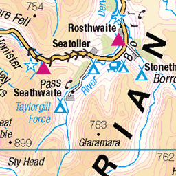
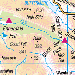
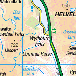
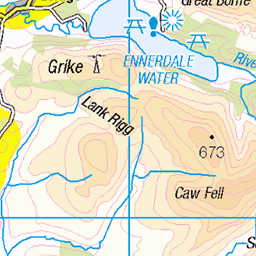
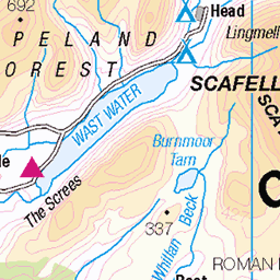
OS Map
This is OS mapping. In some areas, OpenStreetMap shows more footpaths
Spatial NI has online OSNI mapping. Click "Basemap Gallery" (4 squares icon at the top).
Now would be a good time for a cup of tea.


GPX Editor
Record map clicks
Reload map
Photos
Please tag your photos and upload them to the British and Irish Mountains group on Flickr
The other photos have been geo-tagged as on or around the summit. For less busy mountains, it can be a little hit and miss.
Dodd Hill 1
Dodd Hill lies near to Bassenthwaite Lake. This was shot from the path leading to St Bega's Church.
05-Mar-25 • Bill Cumming • flickr
cumbria lakedistrict bassenthwaite doddhill 2025 54371710471
IMG_5283_edited-1
We stayed at a hotel on the shores of Bassenthwaite Lake, north of Keswick in the Lake District. In the morning there was a layer of fog lingering on the lake. As we walked down to the shore we passed this solitary tree which was backlit by the sun just starting to shine through the fog.
18-Nov-24 • ianmoran973 • flickr
54217348900
photo
Heading up to Ullock Pike.
22-Sep-24 • Steve Hodgson Photos • flickr
cumbria lakedistrict 54016851582
photo
Hike up Ullock pike, Long side and Carl side. View to Skiddaw
22-Sep-24 • Steve Hodgson Photos • flickr
skiddaw lakedistrict cumbria 54017980233
photo
Hike up Ullock pike, Long side and Carl side. View to Skiddaw
22-Sep-24 • Steve Hodgson Photos • flickr
skiddaw lakedistrict cumbria 54018189440

photo
Hike up Ullock pike, Long side and Carl side.
22-Sep-24 • Steve Hodgson Photos • flickr
path lakedistrict cumbria 54017757131

photo
Hike up Ullock pike, Long side and Carl side.
22-Sep-24 • Steve Hodgson Photos • flickr
ullockpike bassenthwaite lakedistrict cumbria 54017757101

Oak woodland by Bassenthwaite Lake.
The track leads to St. Begas' Church, to the right behind the large tree. Very close to the spot that inspired Alfred Tennyson with his poem Morte d' Arthur. Arthur, dying, bids Sir Bedivere cast Excalibur into the mere which he reluctantly does on his third attempt. So flashed and fell the brand Excalibur But ere he dipt the surface, rose an arm Clothed in white samite, mystic, wonderful. And caught him by the hilt, ...
02-Feb-23 • greengrocer48 • flickr
cumbria england lakedistrict bassenthwaitelake stbegaschurch sessileoakwoodland alfredlordtennyson mortedarthur 54217239223

Videos
Towering over Keswick in the English Lake District is Skiddaw. At 931-metres (3054 ft), Skiddaw is England's sixth highest ...
Headed to the Lake District with the Mrs for this one. We had limited time so planned a 4hr hike starting out in Dodd Wood to ...
A first ever collaboration with Chris from @Bonny Lads on Tour and we had a real fun day climbing 4 Wainwrights, Ullock Pike, ...
A 6 mile walk up Skiddaw via Ullock Pike and Longside Edge. From the start the route follows the ridge over The Edge to Ullock ...
Hike to summit of Ullock Pike, Longside and Carlside in the northern fells of the Lake District. Views of Skiddaw, Bassenthwaite ...
Notes
- Data: Database of British and Irish Hills v18.2
- Maps: We use OS mapping for England, Scotland, Wales, and the Isle of Man. Sadly, Channel Islands, Northern (OSNI) and Southern Ireland (OSI) mapping isn't available online, so we use Openstreetmap.