Hills of Britain and Ireland
OS Map of Sighty Crag

Northern Nights.....
Whilst out wild camping I was treat to a northern lights display. Checkout the video here - youtu.be/wnOg9BP4ZQc" rel="noreferrer nofollow youtu.be/wnOg9BP4ZQc
16-Apr-21 • CamraMan. • flickr
aurora northernlights wildcamping sonya6100 sigma16mmf14 msrhubbanx1 ©camraman 51122301512

Fading Light..
The last of the sun's rays lighting up the lower fells of Sighty Crag before settling down to cold and windy night in the tent.
14-Apr-19 • CamraMan. • flickr
sightycrag wildcamping trigpoint christianburycrags bewcastlefells heather moors moorland sonyhx80 ©davidliddle ©camraman 47571797672

Sunset Trig...
Another sunset another wild camp, Sighty Crag was this weekends choice and bitterly cold it was with that easterly wind blowing in.
13-Apr-19 • CamraMan. • flickr
sightycrag trigpoint bewcastlefells sunset cumbria northcumbria bewcastle sonya6000 samyang12mm benro moors fells ©davidliddle ©camraman 33731861578

A Sheltered Spot..
It was such a windy day when I arrived (30mph winds) I had to find a suitably sheltered location safe from the easterly wind. I found this spot just down from the trig point on Sighty Crag. Elevation 518 m (1,699 ft) NY601809
13-Apr-19 • CamraMan. • flickr
stars sightycrag hillebergakto wildcamping cumbria bewcastlefells windy sonya6000 benro ©davidliddle ©camraman samyang12mm 46697349365
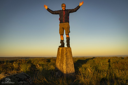
Trig Selfie...
It had to be done the obligatory selfie shot whilst on my wildcamp to Sighty Crag. The Gaitors stopped my legs from being attacked by the dry heather on my way up and I never took them off till later on. It was a case of I had 10 secs to get into position or look stupid lol , but I still look stupid doh..
30-Jun-18 • CamraMan. • flickr
selfie sightycrag trigpoint sunset ©davidliddle ©camraman sonya7 bewcastlefells cumbria views 43160501042
Night on the Hills.
The view from my Tent as the sunset's over the Scottish Hills after a hot sunny day on the Bewcastle fells. Location is Sighty Crag which is apparently the remotest Marilyn in the whole of the UK. Elavation 518 m (1,699 ft) NY601809
30-Jun-18 • CamraMan. • flickr
hilleberg akto hillebergakto wildcamp wildcamping bewcastlefells christianburycrags sunset hills sightycrag ©davidliddle ©camraman panasoniclumixtz60 marilyn hill 42254180735
OS Map
This is OS mapping. In some areas, OpenStreetMap shows more footpaths
Spatial NI has online OSNI mapping. Click "Basemap Gallery" (4 squares icon at the top).
Now would be a good time for a cup of tea.
GPX Editor
Record map clicks
Reload map
Photos
Please tag your photos and upload them to the British and Irish Mountains group on Flickr
The other photos have been geo-tagged as on or around the summit. For less busy mountains, it can be a little hit and miss.
Northern Nights.....
Whilst out wild camping I was treat to a northern lights display. Checkout the video here - youtu.be/wnOg9BP4ZQc" rel="noreferrer nofollow youtu.be/wnOg9BP4ZQc
16-Apr-21 • CamraMan. • flickr
aurora northernlights wildcamping sonya6100 sigma16mmf14 msrhubbanx1 ©camraman 51122301512
Fading Light..
The last of the sun's rays lighting up the lower fells of Sighty Crag before settling down to cold and windy night in the tent.
14-Apr-19 • CamraMan. • flickr
sightycrag wildcamping trigpoint christianburycrags bewcastlefells heather moors moorland sonyhx80 ©davidliddle ©camraman 47571797672
Sunset Trig...
Another sunset another wild camp, Sighty Crag was this weekends choice and bitterly cold it was with that easterly wind blowing in.
13-Apr-19 • CamraMan. • flickr
sightycrag trigpoint bewcastlefells sunset cumbria northcumbria bewcastle sonya6000 samyang12mm benro moors fells ©davidliddle ©camraman 33731861578
A Sheltered Spot..
It was such a windy day when I arrived (30mph winds) I had to find a suitably sheltered location safe from the easterly wind. I found this spot just down from the trig point on Sighty Crag. Elevation 518 m (1,699 ft) NY601809
13-Apr-19 • CamraMan. • flickr
stars sightycrag hillebergakto wildcamping cumbria bewcastlefells windy sonya6000 benro ©davidliddle ©camraman samyang12mm 46697349365
Trig Selfie...
It had to be done the obligatory selfie shot whilst on my wildcamp to Sighty Crag. The Gaitors stopped my legs from being attacked by the dry heather on my way up and I never took them off till later on. It was a case of I had 10 secs to get into position or look stupid lol , but I still look stupid doh..
30-Jun-18 • CamraMan. • flickr
selfie sightycrag trigpoint sunset ©davidliddle ©camraman sonya7 bewcastlefells cumbria views 43160501042
Night on the Hills.
The view from my Tent as the sunset's over the Scottish Hills after a hot sunny day on the Bewcastle fells. Location is Sighty Crag which is apparently the remotest Marilyn in the whole of the UK. Elavation 518 m (1,699 ft) NY601809
30-Jun-18 • CamraMan. • flickr
hilleberg akto hillebergakto wildcamp wildcamping bewcastlefells christianburycrags sunset hills sightycrag ©davidliddle ©camraman panasoniclumixtz60 marilyn hill 42254180735

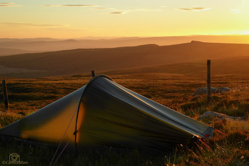
Room with a view..
My location for today's wild camp, giving great views was on the Long Bar up on the Bewcastle Fells.
27-May-18 • CamraMan. • flickr
christianburycrags sunset panasoniclumixtz60 bewcastlefells nature wildcamping cumbria felltops sunny jackwolfskingossamer tent photography ©davidliddle ©camraman 41556695585

In need of Hydration....
From my walk on the Bewcastle fells a few week back, normally these fells are glaggy as hell and I can't remember seeing them this dry . A dry walk which is very unusual up here.
11-May-17 • CamraMan. • flickr
peat bog bewcastlefells cumbria nature dry ©camraman ©davidliddle may2017 walking panasoniclumixtz60 peatbog 34942716765

Sighty Crag Trig Point..
Sighty Crag is a hill in the southern part of the Kielder Forest region in northern England, a region which also includes its fellow Marilyns of Peel Fell and Larriston Fells. It is separated from its higher and more shapely counterpart, Peel Fell, by the low valley in which sits the village of Kielder. The summit is marked by a wind-worn outcrop of fell sandstone. The hill is situated in a particularly remote part of northern Cumbria (although the Northumberland border runs over the north top just 600m from the top). It is four miles from the nearest road, making any walk to the summit and back at least eight miles long. Despite not being especially high, in terms of distance from civilisation it is the remotest Marilyn in the whole of England. ©David Liddle Elavation 518 m (1,699 ft) NY601809
11-May-17 • CamraMan. • flickr
marilyns 518m trigpoint os outandabout whitelyne bewcastlefells cumbria sky clouds moor panasoniclumixtz60 ©camraman christianburycrags sightycrag 34651938845

2313 Sighty Crag
5 hour yomp as James Trail's route with yellow way markers to near Christianbury Crag in dry sunny condition with fierce east wind. Final English Marilyn. Name:Sighty Crag Hill number:2313 Height:520m / 1706ft RHB Section:33: The Scottish Border to the River Tyne County/UA:Cumbria (CoU) Catchment:Eden (Carlisle), Catchment Boundaries, Esk (Gretna) Class:Marilyn, Hump, Dodd (500-599m), Dewey Grid ref:NY 60134 80921 Summit feature:rock outcrop Drop:295m Col:225m NY601972 Observations:outcrop is 5m WSW of trig point and 0.9m above FB
13-May-09 • Dugswell2 • flickr
trigpoint sightycrag p295 marilyn hump dewey tump 46105734825

2313 Sighty Crag a
13-May-09 • Dugswell2 • flickr
trigpoint sightycrag p295 marilyn hump dewey tump 46105744055

10862 - Whitelyne Common
NY601809, LR80. HISTORY The original pillar was completed on 17th May 1936 with FB No. S1553, the cost is not on record. Computed as primary triangulation station PP93 within figure 3 of the OSGB36 retriangulation during 1937. Levelled to second class precision in 1958, concurrent with the reconnaissance of neighbouring secondary block NT72. Upon destruction of the original pillar, a replacement pillar was completed 12th October 1962 using FB 10862, and was last routinely maintained by the Ordnance Survey in June 1978. This marker continues to be maintained by the OS as a GPS passive station. SITE VISIT Sighty Crag. The pillar is in good condition. The spider retains an OS centre cap with raised letters. The flush bracket faces SSE, compass measurement 157°. Pillar vented through the front sight hole (FB face). The remains of the original pillar S1553 lie nearby with the stalk of the flush bracket still in situ. Photographed: 21st Sept' 2008, GRP. ═════════════════════════ Map: www.flickr.com/photos/13460108@N06/30098954708/in/album-72157692190778971/ Trig Pillars on OS Landranger 80 ═════════════════════════ Neighbouring Triangulation Pillars www.flickr.com/photos/13460108@N06/8098030737/in/set-72157631793900484 S6502 - Long Crag : 1.65 miles to the southwest. www.flickr.com/photos/13460108@N06/8100944538/in/album-72157631801120468/ S7430 - Black Knowe : 2.49 miles to the east. www.flickr.com/photos/13460108@N06/8098032419/in/set-72157631793900484/ S6492 - Little Hen Hill : 3.83 miles to the southeast. www.flickr.com/photos/13460108@N06/8100970551/in/album-72157631801120468/ S7998 - Glendhu Hill : 3.97 miles to the northwest. www.flickr.com/photos/13460108@N06/8098039102/in/set-72157631793900484/ S6498 - Black Knors : 4.20 miles to the west. www.flickr.com/photos/13460108@N06/8109878141/in/album-72157631821839859/ S8081 - Greenside : 4.84 miles to the northeast. ═════════════════════════
21-Sep-08 • Graeme5015 • flickr
whitelynecommon s1553 10862 sightycrag 8117270727
Videos
Come with me on this one nighter deep in to kielder forest right next to the stunning reservoir. Some great scenery, good food and ...
A 13 mile walk from the dam wall of Kielder Water. The route follows the eastern shore of the Kielder, passing the various ...
Notes
- Data: Database of British and Irish Hills v18.2
- Maps: We use OS mapping for England, Scotland, Wales, and the Isle of Man. Sadly, Channel Islands, Northern (OSNI) and Southern Ireland (OSI) mapping isn't available online, so we use Openstreetmap.