Hills of Britain and Ireland
OS Map of Diffwys
Height: 750m / 2462ft • Prominence: 148m / 486ft • Summit : ground 5m N of trig point • Trip reports (hill-bagging)

photo
Looking towards the summit of Y Llethr, one of the Rhinog peaks in north-west Wales.
23-Sep-22 • OutdoorMonkey • flickr
wales snowdonia rhinogs rhinogydd outside outdoor rural nature natural scenic scenery countryside hill hillside mountain mountainside cloud clouds cloudy wall walls rock yllethr 52402406489

Diffwys
The summit of Diffwys in Snowdonia, seen from the 688m point the north-east.
23-Sep-22 • OutdoorMonkey • flickr
wales snowdonia rhinogs rhinogydd outside outdoor rural nature natural scenic scenery countryside hill hillside mountain mountainside diffwys wall panorama peak 52402553005

Clawdd Y Rhinogydd.
The great wall that runs along the length of Y Rhinogydd. This section is just west of the summit of Diffwys.
04-Feb-22 • myfyrtomos • flickr
51861239512


On our way to Diffwys, Snowdonia
A week staying near Betws Garmon, on the road between Beddgelert and Caernarfon. Hike 7 took us on to Diffwys from Tal-y-bont. The forecast said 10% chance of rain. We had at least 3 hours of rain in the low cloud. Consequently, it was boggy and rough and we didn't see much until the afternoon, when we were almost back at the car.
09-Jul-21 • Miche & Jon Rousell • flickr
wales northwales snowdonia gwynedd talybont diffwys moss green iphone iphonography iphone11 51420220012

Odd Rock Out
www.youtube.com/watch?v=HrxX9TBj2zY" rel="noreferrer nofollow www.youtube.com/watch?v=HrxX9TBj2zY
28-Apr-19 • RoystonVasey • flickr
canon eos m efm 1855mm f3556 is stm wales snowdonia rhinogydd cwn nantcol llyn hywel y llethr rhinog fach cribyrhiw diffwys dry stone wall 51414653271
OS Map
This is OS mapping. In some areas, OpenStreetMap shows more footpaths
Spatial NI has online OSNI mapping. Click "Basemap Gallery" (4 squares icon at the top).
Now would be a good time for a cup of tea.
GPX Editor
Record map clicks
Reload map
Photos
Please tag your photos and upload them to the British and Irish Mountains group on Flickr
The other photos have been geo-tagged as on or around the summit. For less busy mountains, it can be a little hit and miss.
photo
Looking towards the summit of Y Llethr, one of the Rhinog peaks in north-west Wales.
23-Sep-22 • OutdoorMonkey • flickr
wales snowdonia rhinogs rhinogydd outside outdoor rural nature natural scenic scenery countryside hill hillside mountain mountainside cloud clouds cloudy wall walls rock yllethr 52402406489
Diffwys
The summit of Diffwys in Snowdonia, seen from the 688m point the north-east.
23-Sep-22 • OutdoorMonkey • flickr
wales snowdonia rhinogs rhinogydd outside outdoor rural nature natural scenic scenery countryside hill hillside mountain mountainside diffwys wall panorama peak 52402553005
Clawdd Y Rhinogydd.
The great wall that runs along the length of Y Rhinogydd. This section is just west of the summit of Diffwys.
04-Feb-22 • myfyrtomos • flickr
51861239512
On our way to Diffwys, Snowdonia
A week staying near Betws Garmon, on the road between Beddgelert and Caernarfon. Hike 7 took us on to Diffwys from Tal-y-bont. The forecast said 10% chance of rain. We had at least 3 hours of rain in the low cloud. Consequently, it was boggy and rough and we didn't see much until the afternoon, when we were almost back at the car.
09-Jul-21 • Miche & Jon Rousell • flickr
wales northwales snowdonia gwynedd talybont diffwys moss green iphone iphonography iphone11 51420220012
Odd Rock Out
www.youtube.com/watch?v=HrxX9TBj2zY" rel="noreferrer nofollow www.youtube.com/watch?v=HrxX9TBj2zY
28-Apr-19 • RoystonVasey • flickr
canon eos m efm 1855mm f3556 is stm wales snowdonia rhinogydd cwn nantcol llyn hywel y llethr rhinog fach cribyrhiw diffwys dry stone wall 51414653271

Nice Soup
www.youtube.com/watch?v=dXNf7gzv11s" rel="noreferrer nofollow www.youtube.com/watch?v=dXNf7gzv11s
28-Apr-19 • RoystonVasey • flickr
canon eos m efm 1855mm f3556 is stm wales snowdonia rhinogydd cwn nantcol llyn hywel y llethr rhinog fach cribyrhiw diffwys dry stone wall 51415642510

There She Goes
www.youtube.com/watch?v=68MKLkNSMN4" rel="noreferrer nofollow www.youtube.com/watch?v=68MKLkNSMN4
28-Apr-19 • RoystonVasey • flickr
canon eos m efm 1855mm f3556 is stm wales snowdonia rhinogydd cwn nantcol llyn hywel y llethr rhinog fach cribyrhiw diffwys dry stone wall 51414921488

Downdraught
www.youtube.com/watch?v=mC-3wtAFSmE" rel="noreferrer nofollow www.youtube.com/watch?v=mC-3wtAFSmE
28-Apr-19 • RoystonVasey • flickr
canon eos m efm 1855mm f3556 is stm wales snowdonia rhinogydd cwn nantcol llyn hywel y llethr rhinog fach cribyrhiw diffwys dry stone wall 51415412114
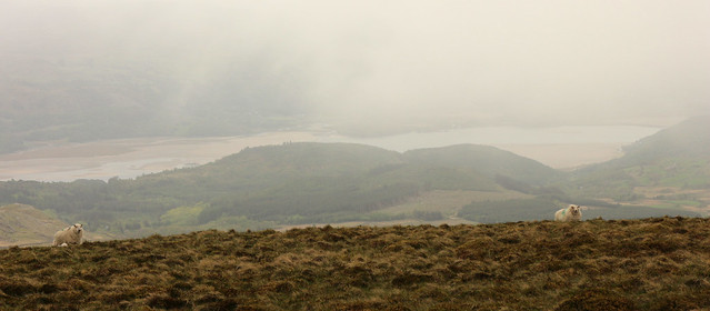
Afon Mawddach
The view to the south, guarded by the locals
28-Apr-19 • RoystonVasey • flickr
canon eos m efm 1855mm f3556 is stm wales snowdonia rhinogydd cwn nantcol llyn hywel y llethr rhinog fach cribyrhiw diffwys old coach route london harlech 51417079523
Videos
A hike to the summit of Diffwys, 750m, the most southern peak in the Rhinogydd. A quiet and relatively remote area of southern ...
On a mission up Diffwys Newydd to see if i could abseil past flooded chamber via level above.
A hike up this moorland mountain near Barmouth in North Wales. By the way, I apologise for mispronouncing Diffwys as "Dipwys"
I was late getting out this afternoon so my options were limited, but glad I made the right decision as I found something you don't ...
Diffwys (Rhinogydd)
Notes
- Data: Database of British and Irish Hills v18.2
- Maps: We use OS mapping for England, Scotland, Wales, and the Isle of Man. Sadly, Channel Islands, Northern (OSNI) and Southern Ireland (OSI) mapping isn't available online, so we use Openstreetmap.