Hills of Britain and Ireland
Map of Mullaghcleevaun
Height: 847m / 2778ft • Prominence: 371m / 1217ft • Summit : trig point • Trip reports (MountainViews)

Mullaghcleevaun Mountain
Looking from near the East Top (790m) toward Mullaghcleevaun (849m). The mountains don't look very high as they're a vast plateau.
27-Jul-19 • Strike here, a clean death • flickr
2019 boulders landscape leinster mullaghcleevaun mullaghcleevauneasttop outdoor rocks summer wicklow wicklowmountains clouds green hiking ireland mountain sky stones 48395882517
East Top (I see you)
Looking from the near the Mullaghcleevaun East Top (790m) toward Mullaghcleevaun (849m).
27-Jul-19 • Strike here, a clean death • flickr
2019 boulders landscape leinster mullaghcleevaun mullaghcleevauneasttop outdoor rocks summer wicklow wicklowmountains clouds green hiking ireland mountain sky stones 48395883277

Mullaghcleevaun East Top Cairn
The summit cairn on top of Mullaghcleevaun East Top (790m).
27-Jul-19 • Strike here, a clean death • flickr
2019 boulders landscape leinster mullaghcleevaun mullaghcleevauneasttop outdoor rocks summer wicklow wicklowmountains cairn clouds green hiking ireland mountain sky stones summit 48396009552

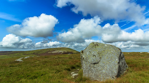
Mullaghcleevaun Summit (849m)
Shark like boulder at the summit of Mullaghcleevaun.
27-Jul-19 • Strike here, a clean death • flickr
2019 boulders landscape leinster mullaghcleevaun outdoor rocks summer wicklow wicklowmountains clouds green hiking ireland mountain sky stones summit 48399197416

Mullaghcleevaun
Ascent of Mullaghcleevaun with a view towards Tonelagee
08-Apr-09 • LeonDolman • flickr
ireland geotagged countywicklow cloghoge geo:lat=5310026929 geo:lon=638477847 4406997558

Mullaghcleevaun top
08-Apr-09 • LeonDolman • flickr
ireland geotagged countywicklow garryknock geo:lat=5310355336 geo:lon=640671536 4406997726
Open Street Map
This is Open Street Map mapping. Sorry, (topographic) OSNI/Channel Islands/OSI mapping is not available online
Spatial NI has online OSNI mapping. Click "Basemap Gallery" (4 squares icon at the top).
Now would be a good time for a cup of tea.
GPX Editor
Record map clicks
Reload map
Photos
Please tag your photos and upload them to the British and Irish Mountains group on Flickr
The other photos have been geo-tagged as on or around the summit. For less busy mountains, it can be a little hit and miss.
Mullaghcleevaun Mountain
Looking from near the East Top (790m) toward Mullaghcleevaun (849m). The mountains don't look very high as they're a vast plateau.
27-Jul-19 • Strike here, a clean death • flickr
2019 boulders landscape leinster mullaghcleevaun mullaghcleevauneasttop outdoor rocks summer wicklow wicklowmountains clouds green hiking ireland mountain sky stones 48395882517
East Top (I see you)
Looking from the near the Mullaghcleevaun East Top (790m) toward Mullaghcleevaun (849m).
27-Jul-19 • Strike here, a clean death • flickr
2019 boulders landscape leinster mullaghcleevaun mullaghcleevauneasttop outdoor rocks summer wicklow wicklowmountains clouds green hiking ireland mountain sky stones 48395883277
Mullaghcleevaun East Top Cairn
The summit cairn on top of Mullaghcleevaun East Top (790m).
27-Jul-19 • Strike here, a clean death • flickr
2019 boulders landscape leinster mullaghcleevaun mullaghcleevauneasttop outdoor rocks summer wicklow wicklowmountains cairn clouds green hiking ireland mountain sky stones summit 48396009552
Mullaghcleevaun Summit (849m)
Shark like boulder at the summit of Mullaghcleevaun.
27-Jul-19 • Strike here, a clean death • flickr
2019 boulders landscape leinster mullaghcleevaun outdoor rocks summer wicklow wicklowmountains clouds green hiking ireland mountain sky stones summit 48399197416
Mullaghcleevaun
Ascent of Mullaghcleevaun with a view towards Tonelagee
08-Apr-09 • LeonDolman • flickr
ireland geotagged countywicklow cloghoge geo:lat=5310026929 geo:lon=638477847 4406997558
Mullaghcleevaun top
08-Apr-09 • LeonDolman • flickr
ireland geotagged countywicklow garryknock geo:lat=5310355336 geo:lon=640671536 4406997726
Videos
hiking #mystery #aviation #epic #nature.
Mullaghcleevaun - the second highest peak in the Wicklow Mountains, Ireland, at 849 metres.
ireland #hikinginireland #travel #wicklow #wicklowmountains #lugnaquilla #bray #funnyvideo #sunnyday #drone ...
Drone 4K footage. Hidden gem, spectacular views. I hiked from Ballynultagh Gap to Mullaghcleevaun mountain. It took me around ...
Notes
- Data: Database of British and Irish Hills v18.2
- Maps: We use OS mapping for England, Scotland, Wales, and the Isle of Man. Sadly, Channel Islands, Northern (OSNI) and Southern Ireland (OSI) mapping isn't available online, so we use Openstreetmap.