Hills of Britain and Ireland
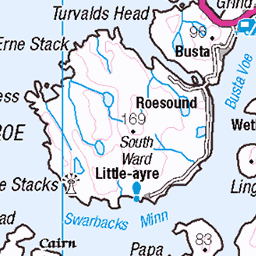
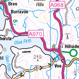
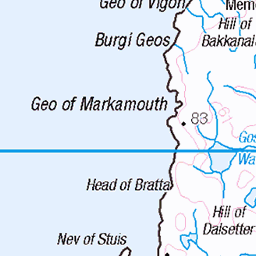
OS Map of Ronas Hill
Height: 450m / 1476ft • Prominence: 450m / 1476ft • Summit : oblique pink granite slab • Trip reports (hill-bagging)


S5494 - Ronas Hill
HU305834, LR1 & LR3. HISTORY Pillar completed 27th May 1949 costing exactly £40. Computed as primary triangulation station PP462 within Figure 6 of the OSGB36 retriangulation network during 1951. This station was also used for the reconnaissance of secondary block HU46 (Shetlands), and levelled to second class precision during 1961. This pillar station was last maintained by the Ordnance Survey in May 1980. SITE VISIT Overall approach from east. Parked at top of road on Collafirth Hill by masts at HU334835. This road can be driven by car and seems to be open to public, information board at top. Route is WNW via Mid Field, west onto bealach and beeline southwest up Ronas Hill to its summit. Highest point on the Shetland Islands. Rocky plateau but easy underfoot. Stone built pillar within wind shelter in fair condition. Spider has replacement OS centre cap with raised small narrow letters. Flush bracket faces ENE, ~59°. Vented through SW sight hole. Full 360° panoramic view includes Foula. Photographed: 23rd June 2015, GRP. ═════════════════════════ Interactive index: www.google.com/maps/d/viewer?mid=1arx2Qmo5mVeVUJA2lzVG_uzbYPW59ffh&ll=60.533816,-1.445537&z=12" rel="noreferrer nofollow Google My Maps Map: www.flickr.com/photos/13460108@N06/42861274700/in/album-72157692190778971/ Trig Pillars on OS Landranger 1 Map: www.flickr.com/photos/13460108@N06/30800609038/in/album-72157692190778971/ Trig Pillars on OS Landranger 3 ═════════════════════════ Neighbouring Triangulation Pillars www.flickr.com/photos/13460108@N06/20088735102/in/album-72157631838876970/ 10578 - White Grunafirth : 2.51 miles to the southwest. www.flickr.com/photos/13460108@N06/20096688235/in/album-72157631838876970/ 10440 - The Faither : 3.35 miles to the west. www.flickr.com/photos/13460108@N06/19046601943/in/album-72157631831281682/ S9546 - Hill Of Ollaberry : 3.70 miles to the east. www.flickr.com/photos/13460108@N06/19046602173/in/album-72157631838876970/ 10513 - Skelberry : 4.16 miles to the northeast. www.flickr.com/photos/13460108@N06/20041073276/in/album-72157631838876970/ 10464 - Hamars Of Burraland : 5.15 miles to the south. www.flickr.com/photos/13460108@N06/19660437502/in/album-72157631838876970/ 10444 - Lanchestoo : 6.66 miles to the northeast. www.flickr.com/photos/13460108@N06/19879276978/in/album-72157631838876970/ 10455 - Esha Ness : 6.79 miles to the southwest. ═════════════════════════
23-Jun-15 • Graeme5015 • flickr
pillar shetland triangulation trigpoint ronas shetlandisles triangulationpillar ronashill heylor s5494 19480897799

Bonxie
The hills belong to the Skuas around here. Expect to be checked out by the locals if you visit ...
22-Sep-14 • We travel the Spaceways • flickr
15431678241

Ronas Hill chambered cairn
Lovely chambered cairn on summit of Ronas Hill, highest point on Shetland.
22-Sep-14 • We travel the Spaceways • flickr
15248326187

1527 Ronas Hill
Name:Ronas Hill Hill number:1527 Height:450m / 1476ft Area:22: Shetland Islands Class:Ma,CoH,CoU,CoA Grid ref:HU 30503 83478 Summit feature:oblique pink granite slab Drop:450m Col:Sea Shetland (1974) administrative county top Shetland historic county top Shetland Islands current county/UA top
26-May-13 • Dugswell2 • flickr
marilyn shetlandislands ronashill countytop p450 9060804574
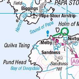
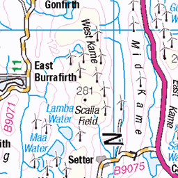
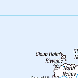
OS Map
This is OS mapping. In some areas, OpenStreetMap shows more footpaths
Spatial NI has online OSNI mapping. Click "Basemap Gallery" (4 squares icon at the top).
Now would be a good time for a cup of tea.


GPX Editor
Record map clicks
Reload map
Photos
Please tag your photos and upload them to the British and Irish Mountains group on Flickr
The other photos have been geo-tagged as on or around the summit. For less busy mountains, it can be a little hit and miss.
S5494 - Ronas Hill
HU305834, LR1 & LR3. HISTORY Pillar completed 27th May 1949 costing exactly £40. Computed as primary triangulation station PP462 within Figure 6 of the OSGB36 retriangulation network during 1951. This station was also used for the reconnaissance of secondary block HU46 (Shetlands), and levelled to second class precision during 1961. This pillar station was last maintained by the Ordnance Survey in May 1980. SITE VISIT Overall approach from east. Parked at top of road on Collafirth Hill by masts at HU334835. This road can be driven by car and seems to be open to public, information board at top. Route is WNW via Mid Field, west onto bealach and beeline southwest up Ronas Hill to its summit. Highest point on the Shetland Islands. Rocky plateau but easy underfoot. Stone built pillar within wind shelter in fair condition. Spider has replacement OS centre cap with raised small narrow letters. Flush bracket faces ENE, ~59°. Vented through SW sight hole. Full 360° panoramic view includes Foula. Photographed: 23rd June 2015, GRP. ═════════════════════════ Interactive index: www.google.com/maps/d/viewer?mid=1arx2Qmo5mVeVUJA2lzVG_uzbYPW59ffh&ll=60.533816,-1.445537&z=12" rel="noreferrer nofollow Google My Maps Map: www.flickr.com/photos/13460108@N06/42861274700/in/album-72157692190778971/ Trig Pillars on OS Landranger 1 Map: www.flickr.com/photos/13460108@N06/30800609038/in/album-72157692190778971/ Trig Pillars on OS Landranger 3 ═════════════════════════ Neighbouring Triangulation Pillars www.flickr.com/photos/13460108@N06/20088735102/in/album-72157631838876970/ 10578 - White Grunafirth : 2.51 miles to the southwest. www.flickr.com/photos/13460108@N06/20096688235/in/album-72157631838876970/ 10440 - The Faither : 3.35 miles to the west. www.flickr.com/photos/13460108@N06/19046601943/in/album-72157631831281682/ S9546 - Hill Of Ollaberry : 3.70 miles to the east. www.flickr.com/photos/13460108@N06/19046602173/in/album-72157631838876970/ 10513 - Skelberry : 4.16 miles to the northeast. www.flickr.com/photos/13460108@N06/20041073276/in/album-72157631838876970/ 10464 - Hamars Of Burraland : 5.15 miles to the south. www.flickr.com/photos/13460108@N06/19660437502/in/album-72157631838876970/ 10444 - Lanchestoo : 6.66 miles to the northeast. www.flickr.com/photos/13460108@N06/19879276978/in/album-72157631838876970/ 10455 - Esha Ness : 6.79 miles to the southwest. ═════════════════════════
23-Jun-15 • Graeme5015 • flickr
pillar shetland triangulation trigpoint ronas shetlandisles triangulationpillar ronashill heylor s5494 19480897799
Bonxie
The hills belong to the Skuas around here. Expect to be checked out by the locals if you visit ...
22-Sep-14 • We travel the Spaceways • flickr
15431678241
Ronas Hill chambered cairn
Lovely chambered cairn on summit of Ronas Hill, highest point on Shetland.
22-Sep-14 • We travel the Spaceways • flickr
15248326187
1527 Ronas Hill
Name:Ronas Hill Hill number:1527 Height:450m / 1476ft Area:22: Shetland Islands Class:Ma,CoH,CoU,CoA Grid ref:HU 30503 83478 Summit feature:oblique pink granite slab Drop:450m Col:Sea Shetland (1974) administrative county top Shetland historic county top Shetland Islands current county/UA top
26-May-13 • Dugswell2 • flickr
marilyn shetlandislands ronashill countytop p450 9060804574

1527 Ronas Hill
Tricky tries another jump and pose. 20m WNW of trig point at HU 30525 83475 and 1m higher; large cairn 75m SSE at HU 30555 83420 is about 1.5m lower. Survey: Abney level Name:Ronas Hill Hill number:1527 Height:450m / 1476ft Area:22: Shetland Islands Class:Ma,CoH,CoU,CoA Grid ref:HU 30503 83478 Summit feature:oblique pink granite slab Drop:450m Col:Sea
26-May-13 • Dugswell2 • flickr
marilyn shetlandislands ronashill countytop p450 9058566983

nordmeer 8180608
Nordmeertörn 2012, SUNRISE
urlaub segeln schottland grosbritannien ollaberry nordmeertörn 2012nordmeertörn 7995079675

nordmeer 8180609
Nordmeertörn 2012, SUNRISE
urlaub segeln schottland grosbritannien ollaberry nordmeertörn 2012nordmeertörn 7995081023

nordmeer 8180610
Nordmeertörn 2012, SUNRISE
urlaub segeln schottland grosbritannien ollaberry nordmeertörn 2012nordmeertörn 7995082909

nordmeer 8180611
Nordmeertörn 2012, SUNRISE
urlaub segeln schottland grosbritannien ollaberry nordmeertörn 2012nordmeertörn 7995088870

On Ronas Hill
Olympus OM4, Ektachrome EB100, digitised by photographing the original 35mm slide on a light table using a 12mm extension tube; tethered capture and digital processing in Lightroom. Ronas Hill is the highest in Shetland; it is a Ramsar site, having many rare arctic-alpine plants. "Ronas Hill [...] has a distinctive red colour derived from its granite geology. [... The] gravelly granite surface features unusual alpine plant communities, which occur here at exceptionally low altitudes. The plateau falls away to the north, giving way to lochans and blanket bog. ." ( www.shetland.gov.uk/downloads/file/1593/local-landscape-areas" rel="noreferrer nofollow www.shetland.gov.uk/downloads/file/1593/local-landscape-a... , accessed 2022.01.28) en.wikipedia.org/wiki/Shetland" rel="noreferrer nofollow en.wikipedia.org/wiki/Shetland
14-Jul-94 • Ed Fulton • flickr
eb100 ektachrome film kodak5045 lightpaddigitised olympusom4 ronashill scotland shetland uk unitedkingdom cirrusuncinus eb 51847373571
Videos
This is an unedited recording from my climb (walk up?) Ronas Hill - Shetland's highest point at 450 m - in Northmavine , Shetland ...
Enjoy this highlight reel of free running through Scotland's most northerly island, Shetland (A.K.A. Zetland, the island at the edge ...
Colin's rescuing a sheep during a veloviewer tiling mission on the back of Ronas Hill, Shetland in 2021.
A walk over Ronas Hill and down to Da Lang Ayre in Northmavine, Shetland.
April 2019. Read all about it on the blog: https://shetlandislandswithleah.blog/2019/04/30/back-where-it-all-began/
Notes
- Data: Database of British and Irish Hills v18.2
- Maps: We use OS mapping for England, Scotland, Wales, and the Isle of Man. Sadly, Channel Islands, Northern (OSNI) and Southern Ireland (OSI) mapping isn't available online, so we use Openstreetmap.