Hills of Britain and Ireland
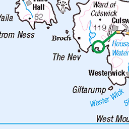
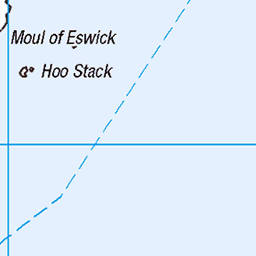
OS Map of Hill of Sandwick


Shetland - Bridge End
To have any images at all during Storm Babet whilst on a work trip with friends I'll call a success. I'd hoped to capture a few more images of beautiful Shetland but the gales said naw. As always, God was good to us, and my stupid photos are but a blip in this life. It's not my favourite image or moment of the trip, but this is stuck forever in my memory because here I was with my camera, alone with pals inside, enjoying this serene view. In solitude. :) There was a very eerie pause in the wind on Tuesday 17 October before the storm properly arrived. This isn't a long exposure. We'd just finished working for the day and I managed to nip out with the pipe and the camera. The floating pier was as still as my steps, which was surprising given the five metre swells we'd felt on the journey north. This building on the left was a home for a week, so regardless of how many images I planned (but failed) to capture this is still quite special to me. 5DSR + TSE 24L II
17-Oct-23 • Edinbruhphotos • flickr
scotland shetland nature mountains highlands beauty canon bridgeend burra hamnavoe island meal beach mealbeach sandsofmeal tse24lii kennymccartney 53297629933

European Pied Flycatcher_hypoleuca_non-br_East Burra Shetland_3-10-21_Nik Borrow WEB
female/male non-breeding East Burra, Shetland 3rd October 2021
03-Oct-21 • nik.borrow • flickr
bird flycatcher shetland 51577318506


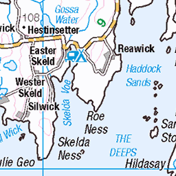
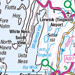
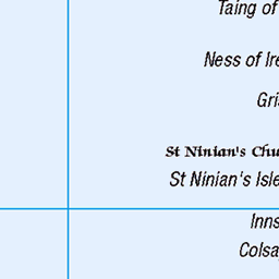
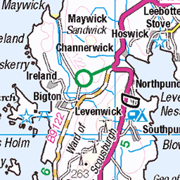
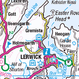
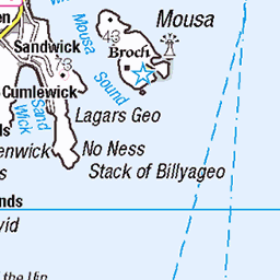
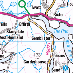
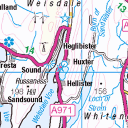
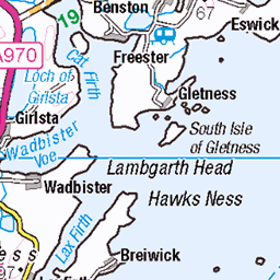
OS Map
This is OS mapping. In some areas, OpenStreetMap shows more footpaths
Spatial NI has online OSNI mapping. Click "Basemap Gallery" (4 squares icon at the top).
Now would be a good time for a cup of tea.


GPX Editor
Record map clicks
Reload map
Photos
Please tag your photos and upload them to the British and Irish Mountains group on Flickr
The other photos have been geo-tagged as on or around the summit. For less busy mountains, it can be a little hit and miss.
Shetland - Bridge End
To have any images at all during Storm Babet whilst on a work trip with friends I'll call a success. I'd hoped to capture a few more images of beautiful Shetland but the gales said naw. As always, God was good to us, and my stupid photos are but a blip in this life. It's not my favourite image or moment of the trip, but this is stuck forever in my memory because here I was with my camera, alone with pals inside, enjoying this serene view. In solitude. :) There was a very eerie pause in the wind on Tuesday 17 October before the storm properly arrived. This isn't a long exposure. We'd just finished working for the day and I managed to nip out with the pipe and the camera. The floating pier was as still as my steps, which was surprising given the five metre swells we'd felt on the journey north. This building on the left was a home for a week, so regardless of how many images I planned (but failed) to capture this is still quite special to me. 5DSR + TSE 24L II
17-Oct-23 • Edinbruhphotos • flickr
scotland shetland nature mountains highlands beauty canon bridgeend burra hamnavoe island meal beach mealbeach sandsofmeal tse24lii kennymccartney 53297629933
European Pied Flycatcher_hypoleuca_non-br_East Burra Shetland_3-10-21_Nik Borrow WEB
female/male non-breeding East Burra, Shetland 3rd October 2021
03-Oct-21 • nik.borrow • flickr
bird flycatcher shetland 51577318506


Videos
Hoswick #Southmainland #Shetland Traveling Shetland Hoswick is a Settlement in Sandwick in the south mainland of Shetland, ...
South Mainland, Shetland, is a narrow peninsula running 25 miles south from Lerwick. In this video we explore the archaeological ...
Enjoying a peaceful Levenwick beach in Shetland all to myself life through my lens.
Notes
- Data: Database of British and Irish Hills v18.2
- Maps: We use OS mapping for England, Scotland, Wales, and the Isle of Man. Sadly, Channel Islands, Northern (OSNI) and Southern Ireland (OSI) mapping isn't available online, so we use Openstreetmap.