Hills of Britain and Ireland
OS Map of Sgurr an Airgid


St. Dubhthach's Church and Clachan Duich Burial Ground, Kintail
St. Dubhthach's Church and Clachan Duich Burial Ground, Kintail - ID:MHG7440 Type of record:Building Name:St. Dubhthach's, Kintail Grid Reference:NG 9463 2104 Map Sheet:NG92SW Civil Parish:KINTAIL Geographical Area:SKYE AND LOCHALSH - ID:MHG31378 Type of record:Monument Name:St. Dubhthach's, Kintail, graveyard Grid Reference:NG 9465 2105 Map Sheet:NG92SW Civil Parish:KINTAIL Geographical Area:SKYE AND LOCHALSH - ID:MHG48840 Type of record:Monument Name:Kintail, St Dubhthac's Church, Clachan Duich Burial Ground Grid Reference:NG 94697 21077 Map Sheet:NG92SW Civil Parish:KINTAIL Geographical Area:SKYE AND LOCHALSH - Kintail, St Dubhthac's Church Church (Period Unassigned) Site Name Kintail, St Dubhthac's Church Classification Church (Period Unassigned) Alternative Name(s) Kintail Old Parish Church; St Duthac's Church; St Dubhtach's Church Canmore ID 12018 Site Number NG92SW 3 NGR NG 94631 21047 Datum OSGB36 - NGR Permalink canmore.org.uk/site/12018" rel="nofollow canmore.org.uk/site/12018 - Kintail, St Dubhthac's Church, Clachan Duich Burial Ground Burial Ground (Period Unassigned), Churchyard (Period Unassigned) Site Name Kintail, St Dubhthac's Church, Clachan Duich Burial Ground Classification Burial Ground (Period Unassigned), Churchyard (Period Unassigned) Alternative Name(s) Churchyard; Kilduich Canmore ID 275649 Site Number NG92SW 3.01 NGR NG 94697 21077 Datum OSGB36 - NGR Permalink canmore.org.uk/site/275649" rel="nofollow canmore.org.uk/site/275649
14-May-18 • Doffcocker • flickr
highlandher mhg7440 mhg31378 mhg48840 42179535761

Scots2018_0753
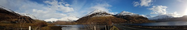
A87 Motorways towards Invergarry, Ault a'chruinn, Kyle, Highland, Scotland, UK
13-May-18 • wallacefsk • flickr
aultachruinn gb greatbritain highland kyle landscape scotland uk unitedkingdom 英國 蘇格蘭 53576183454
OS Map
This is OS mapping. In some areas, OpenStreetMap shows more footpaths
Spatial NI has online OSNI mapping. Click "Basemap Gallery" (4 squares icon at the top).
Now would be a good time for a cup of tea.
GPX Editor
Record map clicks
Reload map
Photos
Please tag your photos and upload them to the British and Irish Mountains group on Flickr
The other photos have been geo-tagged as on or around the summit. For less busy mountains, it can be a little hit and miss.
St. Dubhthach's Church and Clachan Duich Burial Ground, Kintail
St. Dubhthach's Church and Clachan Duich Burial Ground, Kintail - ID:MHG7440 Type of record:Building Name:St. Dubhthach's, Kintail Grid Reference:NG 9463 2104 Map Sheet:NG92SW Civil Parish:KINTAIL Geographical Area:SKYE AND LOCHALSH - ID:MHG31378 Type of record:Monument Name:St. Dubhthach's, Kintail, graveyard Grid Reference:NG 9465 2105 Map Sheet:NG92SW Civil Parish:KINTAIL Geographical Area:SKYE AND LOCHALSH - ID:MHG48840 Type of record:Monument Name:Kintail, St Dubhthac's Church, Clachan Duich Burial Ground Grid Reference:NG 94697 21077 Map Sheet:NG92SW Civil Parish:KINTAIL Geographical Area:SKYE AND LOCHALSH - Kintail, St Dubhthac's Church Church (Period Unassigned) Site Name Kintail, St Dubhthac's Church Classification Church (Period Unassigned) Alternative Name(s) Kintail Old Parish Church; St Duthac's Church; St Dubhtach's Church Canmore ID 12018 Site Number NG92SW 3 NGR NG 94631 21047 Datum OSGB36 - NGR Permalink canmore.org.uk/site/12018" rel="nofollow canmore.org.uk/site/12018 - Kintail, St Dubhthac's Church, Clachan Duich Burial Ground Burial Ground (Period Unassigned), Churchyard (Period Unassigned) Site Name Kintail, St Dubhthac's Church, Clachan Duich Burial Ground Classification Burial Ground (Period Unassigned), Churchyard (Period Unassigned) Alternative Name(s) Churchyard; Kilduich Canmore ID 275649 Site Number NG92SW 3.01 NGR NG 94697 21077 Datum OSGB36 - NGR Permalink canmore.org.uk/site/275649" rel="nofollow canmore.org.uk/site/275649
14-May-18 • Doffcocker • flickr
highlandher mhg7440 mhg31378 mhg48840 42179535761
Scots2018_0753
A87 Motorways towards Invergarry, Ault a'chruinn, Kyle, Highland, Scotland, UK
13-May-18 • wallacefsk • flickr
aultachruinn gb greatbritain highland kyle landscape scotland uk unitedkingdom 英國 蘇格蘭 53576183454

The Five Sisters of Kintail
Taken from the Bealach Ratagain viewpoint Kintail (Scottish Gaelic: Cinn Tàile) is an area of mountains in the Northwest Highlands of Scotland. It consists of the mountains to the north of Glen Shiel between the heads of Loch Duich and Loch Cluanie; its boundaries, other than Glen Shiel, are generally taken to be the valleys of Strath Croe and Gleann Gaorsaic to the north and An Caorann Mòr to the east. Although close to the west coast the mountains lie on the main east-west watershed of Scotland,[2] as the northern side of Kintail drains via Glen Affric[3] to the east coast.
26-Sep-17 • Geoff Threadgill • flickr
natureinfocusgroup coth5 ngc 33536771598

Loch Duich Causeway
The causeway across Loch Duich in Kintail, Scottish Highlands. Taken from Sgurr an Airgid near Morvich. In the foreground is the ancient Clachan Duich burial ground and St Dubthac's Church Wall Art: shop.photo4me.com/1215241/framed-mounted-print?o=21&e=12&s=309&u=mm&share=true" rel="noreferrer nofollow Photo4Me Website: www.vanishingpoints.net" rel="noreferrer nofollow Vanishing Points Facebook: www.facebook.com/vanishingpointsphoto/" rel="noreferrer nofollow @vanishingpointsphoto Instagram: www.instagram.com/markvanpoints/" rel="noreferrer nofollow @markvanpoints
02-Apr-17 • VanishingPoints • flickr
causeway clachanduich road landscape highlands a87 beauty scotland scottish morvich kintail blue brown 52787689075

Videos
Notes
- Data: Database of British and Irish Hills v18.2
- Maps: We use OS mapping for England, Scotland, Wales, and the Isle of Man. Sadly, Channel Islands, Northern (OSNI) and Southern Ireland (OSI) mapping isn't available online, so we use Openstreetmap.