Hills of Britain and Ireland
OS Map of Gulvain (Gaor Bheinn)
Height: 987m / 3238ft • Prominence: 842m / 2762ft • Summit : large cairn • Trip reports (hill-bagging)


Gulvain Munro
Looking south from Gulvain toward Loch Shiel and Moidart. Nice single Munro just 10 minutes drive from our place to the start point.
11-May-19 • Carinbrook • flickr
gulvain munro lochaber mountain 46919665545

The Ben from Gulvain
12-Apr-18 • OutdoorMonkey • flickr
theben bennevis cmd gulvain mountain peak summit mountainside outside outdoor zoom scotland scottish highlands 26795479137

One peak to the other
On Gulvain's lower top looking across to the main summit.
12-Apr-18 • OutdoorMonkey • flickr
gulvain mountain snow peak summit wild wilderness remote outside outdoor countryside scenic scenery hillside mountainside landscape 27794504758

Gulvain summit zoom
Checking out the lie of the land before heading over towards this the highest of Gulvain's two peaks. I must admit I wasn't keen on that last snowy crest up to the summit, and the snow slopes on each side, but once over there it wasn't as bad as it looks.
12-Apr-18 • OutdoorMonkey • flickr
mountain munro gulvain scotland scottish highlands bluesky peak summit ridge crest 40962735144
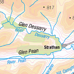
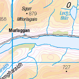
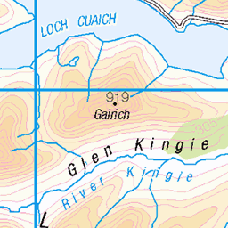
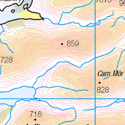
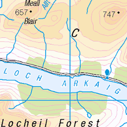
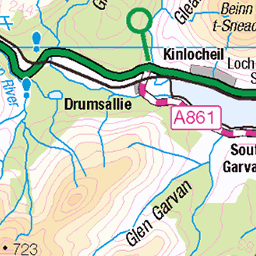
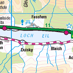
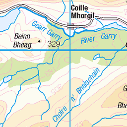
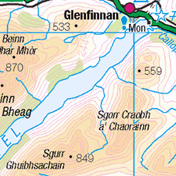
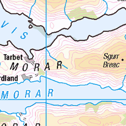
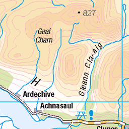
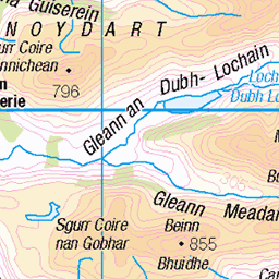
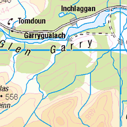
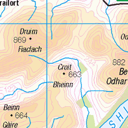
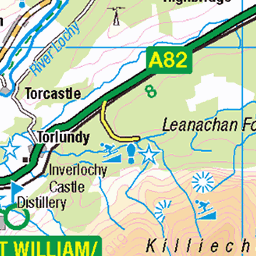
OS Map
This is OS mapping. In some areas, OpenStreetMap shows more footpaths
Spatial NI has online OSNI mapping. Click "Basemap Gallery" (4 squares icon at the top).
Now would be a good time for a cup of tea.


GPX Editor
Record map clicks
Reload map
Photos
Please tag your photos and upload them to the British and Irish Mountains group on Flickr
The other photos have been geo-tagged as on or around the summit. For less busy mountains, it can be a little hit and miss.
Gulvain Munro
Looking south from Gulvain toward Loch Shiel and Moidart. Nice single Munro just 10 minutes drive from our place to the start point.
11-May-19 • Carinbrook • flickr
gulvain munro lochaber mountain 46919665545
The Ben from Gulvain
12-Apr-18 • OutdoorMonkey • flickr
theben bennevis cmd gulvain mountain peak summit mountainside outside outdoor zoom scotland scottish highlands 26795479137
One peak to the other
On Gulvain's lower top looking across to the main summit.
12-Apr-18 • OutdoorMonkey • flickr
gulvain mountain snow peak summit wild wilderness remote outside outdoor countryside scenic scenery hillside mountainside landscape 27794504758
Gulvain summit zoom
Checking out the lie of the land before heading over towards this the highest of Gulvain's two peaks. I must admit I wasn't keen on that last snowy crest up to the summit, and the snow slopes on each side, but once over there it wasn't as bad as it looks.
12-Apr-18 • OutdoorMonkey • flickr
mountain munro gulvain scotland scottish highlands bluesky peak summit ridge crest 40962735144

En route to summit
Between the two peaks on Gulvain on the most glorious of sunny days.
12-Apr-18 • OutdoorMonkey • flickr
mountain munro gulvain scotland scottish highlands bluesky peak summit ridge crest 26805251727

Gulvain panorama
Looking north-east from near Gulvain's main summit, over the ridge on the south side of Coire Sgreamhach and to Ben Nevis in the distance on the right.
12-Apr-18 • OutdoorMonkey • flickr
gulvain mountain peak summit munro scotland panorama panoramic view scenic scenery snow 40782998295

photo
Panoramic view along the ridge linking Gulvain's two summits with Loch Shiel in the centre-distance and Sgurr Thuilm to the right.
12-Apr-18 • OutdoorMonkey • flickr
gulvain mountain peak summit munro scotland panorama panoramic view scenic scenery snow 26805721677

IMG_20151016_114810
16/10/15 Gulvain Myself On the south summit of Gulvain looking Gulvain NM997864 954m
16-Oct-15 • Brian Howarth • flickr
ben fort eil loch willian nevis knoydart gulvain streap 22263031652
![773 Gulvain [Gaor Bheinn]](https://live.staticflickr.com/65535/49661885787_a6c3db0ea0.jpg)
773 Gulvain [Gaor Bheinn]
Cloudy on top dry and warm. Name:Gulvain [Gaor Bheinn] Hill number:773 Height:987m / 3238ft RHB Section:10D: Mallaig to Fort William County/UA:Highland (UA) Catchment:Eil, Catchment Boundaries, Lochy Class:Marilyn, Hump, Simm, Munro, Murdo, Yeaman Grid ref:NN 00272 87565 Summit feature:large cairn Drop:842m Col:145m NM889895
05-Jun-07 • Dugswell2 • flickr
gulvaingaorbheinn p842 tump marilyn hump simm munro murdo yeaman 49661885787
![773 Gulvain [Gaor Bheinn] a](https://live.staticflickr.com/65535/49661063063_3dcd6543fa.jpg)
773 Gulvain [Gaor Bheinn] a
05-Jun-07 • Dugswell2 • flickr
gulvaingaorbheinn p842 tump marilyn hump simm munro murdo yeaman 49661063063
Videos
Gulvain. Solo Hike #hiking #scotland #mountains.
Created by InShot:https://inshotapp.page.link/YTShare.
View across to Gulvain summit from south ridge.
10th December 2024.
Notes
- Data: Database of British and Irish Hills v18.2
- Maps: We use OS mapping for England, Scotland, Wales, and the Isle of Man. Sadly, Channel Islands, Northern (OSNI) and Southern Ireland (OSI) mapping isn't available online, so we use Openstreetmap.