Hills of Britain and Ireland
OS Map of Ben Tee
Height: 904m / 2966ft • Prominence: 356m / 1168ft • Summit : large cairn • Trip reports (hill-bagging)
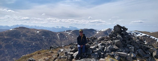
Ben Tee
Corbett Bagging Easter 2022
21-Apr-22 • Phil + Heather • flickr
corbett easter 2022 52026374611
Ben Tee
Corbett Bagging Easter 2022
21-Apr-22 • Phil + Heather • flickr
corbett easter 2022 52026411118

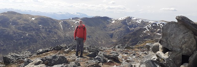
Summit of Sron a Choire Ghairbh
Looking towards Loch Ness
02-Feb-13 • fergusfleming • flickr
photostream 8441116456

761 Ben Tee b
Horizontal sleet and then hail with occasional sunny spells...damp going. Name:Ben Tee Hill number:761 Height:904m / 2966ft RHB Section:10C: Loch Arkaig to Glen Moriston County/UA:Highland (UA) Catchment:Catchment Boundaries, Lochy, Ness Watershed:Inner Moray Firth, Ardnamurchan Point to Lowestoft, Cardiff to Cape Wrath, Dover to Cape Wrath, Lowestoft to Duncansby Head, Greater Loch Linnhe, Land's End to John o' Groats, The Lizard to Dunnet Head Class:Marilyn, Hump, Simm, Corbett, Yeaman Grid ref:NN 24067 97191 Summit feature:large cairn Drop:356m Col:548m NN233967
22-May-07 • Dugswell2 • flickr
bentee p356 tump marilyn hump simm corbett yeaman 49661750262

761 Ben Tee a
22-May-07 • Dugswell2 • flickr
bentee p356 tump marilyn hump simm corbett yeaman 49660929448

761 Ben Tee
22-May-07 • Dugswell2 • flickr
bentee p356 tump marilyn hump simm corbett yeaman 49661749862
OS Map
This is OS mapping. In some areas, OpenStreetMap shows more footpaths
Spatial NI has online OSNI mapping. Click "Basemap Gallery" (4 squares icon at the top).
Now would be a good time for a cup of tea.
GPX Editor
Record map clicks
Reload map
Photos
Please tag your photos and upload them to the British and Irish Mountains group on Flickr
The other photos have been geo-tagged as on or around the summit. For less busy mountains, it can be a little hit and miss.
Ben Tee
Corbett Bagging Easter 2022
21-Apr-22 • Phil + Heather • flickr
corbett easter 2022 52026374611
Ben Tee
Corbett Bagging Easter 2022
21-Apr-22 • Phil + Heather • flickr
corbett easter 2022 52026411118
Summit of Sron a Choire Ghairbh
Looking towards Loch Ness
02-Feb-13 • fergusfleming • flickr
photostream 8441116456
761 Ben Tee b
Horizontal sleet and then hail with occasional sunny spells...damp going. Name:Ben Tee Hill number:761 Height:904m / 2966ft RHB Section:10C: Loch Arkaig to Glen Moriston County/UA:Highland (UA) Catchment:Catchment Boundaries, Lochy, Ness Watershed:Inner Moray Firth, Ardnamurchan Point to Lowestoft, Cardiff to Cape Wrath, Dover to Cape Wrath, Lowestoft to Duncansby Head, Greater Loch Linnhe, Land's End to John o' Groats, The Lizard to Dunnet Head Class:Marilyn, Hump, Simm, Corbett, Yeaman Grid ref:NN 24067 97191 Summit feature:large cairn Drop:356m Col:548m NN233967
22-May-07 • Dugswell2 • flickr
bentee p356 tump marilyn hump simm corbett yeaman 49661750262
761 Ben Tee a
22-May-07 • Dugswell2 • flickr
bentee p356 tump marilyn hump simm corbett yeaman 49660929448
761 Ben Tee
22-May-07 • Dugswell2 • flickr
bentee p356 tump marilyn hump simm corbett yeaman 49661749862
Videos
By Scottish Artist Kevin Hunter.
Day 4 of our recent holiday, and a localish day, the second drone flying location, Invergary Castle, and the sun came out - even if it ...
A solo hike up the 2 Munros to the north of Loch Lochy known as the Loch Lochy Munros, Sron a Choire Ghairbh and Meall na ...
The 2 Loch Lochy Munros, from Kilfinnan. Sròn a' Choire Ghairbh and Meall na Teanga. Solo Hike #hiking #munro #scotland.
scotland #munrobagging #fortwilliam.
Notes
- Data: Database of British and Irish Hills v18.2
- Maps: We use OS mapping for England, Scotland, Wales, and the Isle of Man. Sadly, Channel Islands, Northern (OSNI) and Southern Ireland (OSI) mapping isn't available online, so we use Openstreetmap.