Hills of Britain and Ireland
OS Map of Sron Coire an Fhamhair West Top

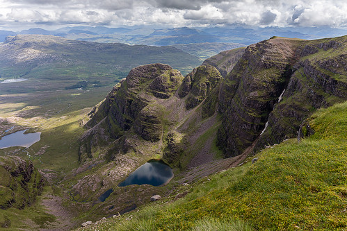
Beinn Bhan
I hadn't been up Beinn Bhan since before Covid and it was such a pleasure to be up there again. Of course the view from the summit has not changed and the little lochans in Coire na Poite are such a delight to see from above. The most striking difference, in my view, is that I did not see a living soul all day. This was always the busiest hill in Applecross (I've been up many times in the past) so I couldn't help but wonder where all the hill walkers and climbers had gone.
01-Sep-24 • AnnieMacD • flickr
applecross bealachnaba beinnbhan mountains scotland westerross 53966282135

S6118 - Beinn Bhan
NG803450, LR24. HISTORY Pillar completed 23rd July 1950 costing £64.0s.4d. Computed as Primary triangulation station PP382 within Figure 6 on the OSGB36 primary retriangulation network during 1951. This station was also used for the reconnaissance of secondary blocks NG24 (Skye) in 1957, NH16 (Wester Ross) in 1958, and NG80 (Fort William) during 1959. Levelled to second class precision in 1958. This pillar station was last maintained by the Ordnance Survey in May 1980. SITE VISIT Overall approach from the southwest. Parked at mapped viewpoint at NG773426. Headed up the track to the mast at the summit of Sguur a' Chaorachain before heading down to the bealach at NG783442. From there it was a near beeline climb up theridge to the summit. With hindsight, I should probable have started this from the west at NG762437 and followed the mapped path to the bealach, thus avoiding the boulder field to the south. Stone built pillar in good condition. Spider centre open. The flush bracket faces southeast compass measurement 153°. Vented through right (NE) sighting hole. Full 360° panoramic view includes primary sight line connections with PP389 (Anteallach), PP386 (Carn Eige), PP371 (Sgurr na Ciche), PP375 (Beinn na Caillich), PP390 (Healaval Beg), PP396 (Storr) and PP373 (An Cuaidh). Photographed: 14th August 2020, GRP. ═════════════════════════ Interactive index: www.google.com/maps/d/viewer?mid=1arx2Qmo5mVeVUJA2lzVG_uzbYPW59ffh&ll=57.442353,-5.661707&z=11" rel="noreferrer nofollow Google My Maps Map: www.flickr.com/photos/13460108@N06/38486285320 Trig Pillars on OS Landranger 24 ═════════════════════════ Neighbouring Triangulation Pillars www.flickr.com/photos/13460108@N06/50940476447/in/album-72157631831281682/ S9775 - Meall Gorm : 2.95 miles to the southwest. www.flickr.com/photos/13460108@N06/50939675113/in/album-72157631831281682/ S9752 - Meall Loch An Fheoir : 4.45 miles to the west. www.flickr.com/photos/13460108@N06/50953776823/in/album-72157631831281682/ S9428 - Croic Bheinn : 5.02 miles to the northwest. S9415 - Ben Shieldaig : 5.19 miles to the north. www.flickr.com/photos/13460108@N06/50951370131/in/album-72157631831281682/ S9801 - Beinn A Chlachain : 5.53 miles to the northwest. S9423 - Glas Bheinn : 6.13 miles to the east. ═════════════════════════
14-Aug-20 • Graeme5015 • flickr
westerross rossshire ross applecross kishorn 50940479167

Beinn Bhan Corries
This is Coire Toll a'Mheine which has to be the most peaceful and secluded of them all.
04-Jul-17 • AnnieMacD • flickr
applecross bealachnaba beinnbhan coiretollamheine mountains scotland westerross unitedkingdom gb 35605380701

The most beautiful corrie in Scotland?
Coire na Poite on Beinn Bhan, Applecross. Well, to me it is anyway! At this time of year everything is green and the little lochans look like jewels. And there is still a sliver of snow in the gully - icing on the cake.
25-Jul-15 • AnnieMacD • flickr
mountains scotland unitedkingdom gb corbett westerross applecross strathcarron beinnbhan achioch coirenapoite 19819120888

Coire na Poite, Beinn Bhan, Applecross
This is in the inner sanctum of the two-tier hanging corrie. The lochans here all have a green appearance (possibly algae?) which show up the reflections of the surrounding slopes. On the left is A'Phoit which is Gaelic for cauldron or pot.
28-Sep-14 • AnnieMacD • flickr
westerross applecross scotlanduk beinnbhan aphoit coirenapoite 15205690147
OS Map
This is OS mapping. In some areas, OpenStreetMap shows more footpaths
Spatial NI has online OSNI mapping. Click "Basemap Gallery" (4 squares icon at the top).
Now would be a good time for a cup of tea.
GPX Editor
Record map clicks
Reload map
Photos
Please tag your photos and upload them to the British and Irish Mountains group on Flickr
The other photos have been geo-tagged as on or around the summit. For less busy mountains, it can be a little hit and miss.
Beinn Bhan
I hadn't been up Beinn Bhan since before Covid and it was such a pleasure to be up there again. Of course the view from the summit has not changed and the little lochans in Coire na Poite are such a delight to see from above. The most striking difference, in my view, is that I did not see a living soul all day. This was always the busiest hill in Applecross (I've been up many times in the past) so I couldn't help but wonder where all the hill walkers and climbers had gone.
01-Sep-24 • AnnieMacD • flickr
applecross bealachnaba beinnbhan mountains scotland westerross 53966282135
S6118 - Beinn Bhan
NG803450, LR24. HISTORY Pillar completed 23rd July 1950 costing £64.0s.4d. Computed as Primary triangulation station PP382 within Figure 6 on the OSGB36 primary retriangulation network during 1951. This station was also used for the reconnaissance of secondary blocks NG24 (Skye) in 1957, NH16 (Wester Ross) in 1958, and NG80 (Fort William) during 1959. Levelled to second class precision in 1958. This pillar station was last maintained by the Ordnance Survey in May 1980. SITE VISIT Overall approach from the southwest. Parked at mapped viewpoint at NG773426. Headed up the track to the mast at the summit of Sguur a' Chaorachain before heading down to the bealach at NG783442. From there it was a near beeline climb up theridge to the summit. With hindsight, I should probable have started this from the west at NG762437 and followed the mapped path to the bealach, thus avoiding the boulder field to the south. Stone built pillar in good condition. Spider centre open. The flush bracket faces southeast compass measurement 153°. Vented through right (NE) sighting hole. Full 360° panoramic view includes primary sight line connections with PP389 (Anteallach), PP386 (Carn Eige), PP371 (Sgurr na Ciche), PP375 (Beinn na Caillich), PP390 (Healaval Beg), PP396 (Storr) and PP373 (An Cuaidh). Photographed: 14th August 2020, GRP. ═════════════════════════ Interactive index: www.google.com/maps/d/viewer?mid=1arx2Qmo5mVeVUJA2lzVG_uzbYPW59ffh&ll=57.442353,-5.661707&z=11" rel="noreferrer nofollow Google My Maps Map: www.flickr.com/photos/13460108@N06/38486285320 Trig Pillars on OS Landranger 24 ═════════════════════════ Neighbouring Triangulation Pillars www.flickr.com/photos/13460108@N06/50940476447/in/album-72157631831281682/ S9775 - Meall Gorm : 2.95 miles to the southwest. www.flickr.com/photos/13460108@N06/50939675113/in/album-72157631831281682/ S9752 - Meall Loch An Fheoir : 4.45 miles to the west. www.flickr.com/photos/13460108@N06/50953776823/in/album-72157631831281682/ S9428 - Croic Bheinn : 5.02 miles to the northwest. S9415 - Ben Shieldaig : 5.19 miles to the north. www.flickr.com/photos/13460108@N06/50951370131/in/album-72157631831281682/ S9801 - Beinn A Chlachain : 5.53 miles to the northwest. S9423 - Glas Bheinn : 6.13 miles to the east. ═════════════════════════
14-Aug-20 • Graeme5015 • flickr
westerross rossshire ross applecross kishorn 50940479167
Beinn Bhan Corries
This is Coire Toll a'Mheine which has to be the most peaceful and secluded of them all.
04-Jul-17 • AnnieMacD • flickr
applecross bealachnaba beinnbhan coiretollamheine mountains scotland westerross unitedkingdom gb 35605380701
The most beautiful corrie in Scotland?
Coire na Poite on Beinn Bhan, Applecross. Well, to me it is anyway! At this time of year everything is green and the little lochans look like jewels. And there is still a sliver of snow in the gully - icing on the cake.
25-Jul-15 • AnnieMacD • flickr
mountains scotland unitedkingdom gb corbett westerross applecross strathcarron beinnbhan achioch coirenapoite 19819120888
Coire na Poite, Beinn Bhan, Applecross
This is in the inner sanctum of the two-tier hanging corrie. The lochans here all have a green appearance (possibly algae?) which show up the reflections of the surrounding slopes. On the left is A'Phoit which is Gaelic for cauldron or pot.
28-Sep-14 • AnnieMacD • flickr
westerross applecross scotlanduk beinnbhan aphoit coirenapoite 15205690147

Beinn Bhan - Coire Toll a' Mheine
Yet another of the Beinn Bhan corries. This one is Coire Toll a' Mheine.
01-Jan-14 • AnnieMacD • flickr
mountains landscape scotland unitedkingdom westerross applecross strathcarron beinnbhan lochlundie coiretollamheine 11783611023
![Beinn Bhan cornices [Explore]](https://live.staticflickr.com/5526/10820763405_1c0ebcb9e6.jpg)
Beinn Bhan cornices [Explore]
Looking directly up at the cornices (cropped).
10-Nov-13 • AnnieMacD • flickr
mountains applecross cornices beinnbhan niksilverefexpro corrienapoite 10820763405

The Corries of Beinn Bhan
Looking east from Coire na Poite towards Beinn Damh with Liathach and Beinn Eighe behind. A' Phoit (the pot) looms large on the left. In the winter the corries do not get much sun so even though it was a lovely day, it was bitterly cold and a little gloomy but magical nonetheless.
10-Nov-13 • AnnieMacD • flickr
winter sunset snow mountains highland applecross beinndamh scotlanduk beinnbhan pwwinter corrienapoite 10800445395

Beinn Bhan Coire na Poite
10-Nov-13 • AnnieMacD • flickr
winter mountains day clear applecross beinnbhan pwwinter corrienapoite 10839394283
Videos
None found
Notes
- Data: Database of British and Irish Hills v18.2
- Maps: We use OS mapping for England, Scotland, Wales, and the Isle of Man. Sadly, Channel Islands, Northern (OSNI) and Southern Ireland (OSI) mapping isn't available online, so we use Openstreetmap.