Hills of Britain and Ireland
OS Map of Lyscombe Hill
Height: 263m / 863ft • Prominence: 102m / 335ft • Summit : ground 25m SSW of wooden telegraph post • Trip reports (hill-bagging)


Wessex Ridgeway (24)
Day 4 Alton Pancras to Shroton
wessexridgeway wessexridgewaytrail wessexridgewaypath 49679719641

Wessex Ridgeway (25)
Day 4 Alton Pancras to Shroton
wessexridgeway wessexridgewaytrail wessexridgewaypath 49679189253

Wessex Ridgeway (26)
Day 4 Alton Pancras to Shroton
wessexridgeway wessexridgewaytrail wessexridgewaypath 49679190248

Wessex Ridgeway (27)
Day 4 Alton Pancras to Shroton Dorsetshire Gap
wessexridgeway wessexridgewaytrail wessexridgewaypath 49680012282

Woods above Dorsetshire Gap
A long walk was planned for the day. It proved to be plagued by thick fog and fine drizzle, for the entirety of our 12 mile slog. The Wessex Ridgeway passes through these woods, changing direction at the fingerpost.
05-Feb-19 • Walruscharmer • flickr
woods bridleway trees wessexridgeway longdistancefootpath dorset dorsetshiregap england 47008044602
OS Map
This is OS mapping. In some areas, OpenStreetMap shows more footpaths
Spatial NI has online OSNI mapping. Click "Basemap Gallery" (4 squares icon at the top).
Now would be a good time for a cup of tea.
GPX Editor
Record map clicks
Reload map
Photos
Please tag your photos and upload them to the British and Irish Mountains group on Flickr
The other photos have been geo-tagged as on or around the summit. For less busy mountains, it can be a little hit and miss.
Wessex Ridgeway (24)
Day 4 Alton Pancras to Shroton
wessexridgeway wessexridgewaytrail wessexridgewaypath 49679719641
Wessex Ridgeway (25)
Day 4 Alton Pancras to Shroton
wessexridgeway wessexridgewaytrail wessexridgewaypath 49679189253
Wessex Ridgeway (26)
Day 4 Alton Pancras to Shroton
wessexridgeway wessexridgewaytrail wessexridgewaypath 49679190248
Wessex Ridgeway (27)
Day 4 Alton Pancras to Shroton Dorsetshire Gap
wessexridgeway wessexridgewaytrail wessexridgewaypath 49680012282
Woods above Dorsetshire Gap
A long walk was planned for the day. It proved to be plagued by thick fog and fine drizzle, for the entirety of our 12 mile slog. The Wessex Ridgeway passes through these woods, changing direction at the fingerpost.
05-Feb-19 • Walruscharmer • flickr
woods bridleway trees wessexridgeway longdistancefootpath dorset dorsetshiregap england 47008044602

Melcombe Park Farm
A long walk was planned for the day. It proved to be plagued by thick fog and fine drizzle, for the entirety of our 12 mile slog. The farm is tucked in beside Hill Wood, and passed by the Wessex Ridgeway on its 137 mile journey between Lyme Regis and Marlborough.
05-Feb-19 • Walruscharmer • flickr
cattle farmyard fog mist gates wessexridgeway longdistancefootpath melcombeparkfarm dorset england 40095357693
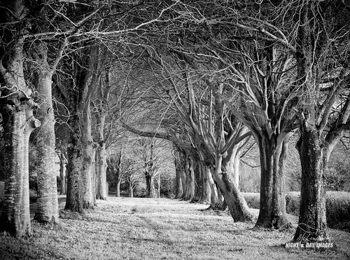
'Out of Line’
I'm never quite sure what it is that makes a picture work. I took 6 shots of this avenue of trees in Dorset during a walk around the Dorset Gap in very wet and windy weather. While I know this one works for me I am hard pressed to tell you what is wrong with the others. Perhaps if I could I would be a better landscape photographer! The row of trees lead to Higher Melcombe , Ansty, Dorset. It looks an absolutely magical place that I intend to explore further.
29-Nov-18 • macdad1948 • flickr
highermelcombe dorset wessex texture grumpies ridgeway ansty avenue blackwhite 44291285760

The Wessex Ridgeway near Alton Pancras
dorset wessexridgeway 30546713385

The Wessex Ridgeway near Alton Pancras
dorset wessexridgeway 30510628466
Videos
A selection of images and a few short clips of our hike through Ansty, Melcombe and Lyscombe, taking a look inside the old ...
In this episode of my series “ Walks in Dorset” I explore around the valley at Lyscombe Bottom – located about 9 miles North of ...
On Sunday morning I walked from Melcombe Bingham to Dorset Gap and then on towards Nethercombe Tout and Lyscombe Hill, ...
This is another video in my series “Walks in Dorset” accompanied by my Whippet (Logan). In this episode I am at the pretty village ...
Notes
- Data: Database of British and Irish Hills v18.2
- Maps: We use OS mapping for England, Scotland, Wales, and the Isle of Man. Sadly, Channel Islands, Northern (OSNI) and Southern Ireland (OSI) mapping isn't available online, so we use Openstreetmap.