Hills of Britain and Ireland
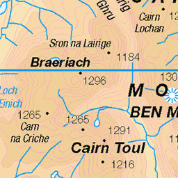
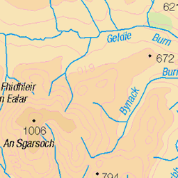
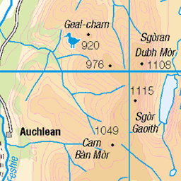
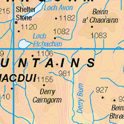
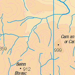
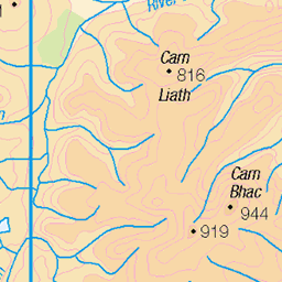
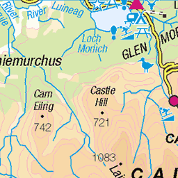
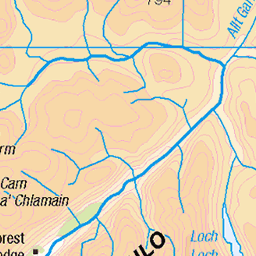
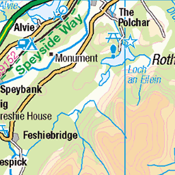
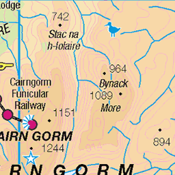
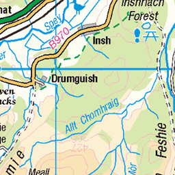
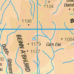
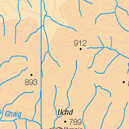
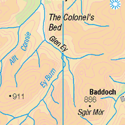
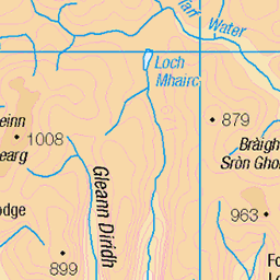
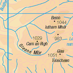
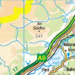
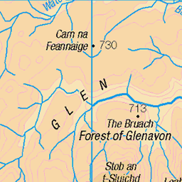
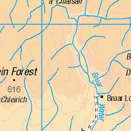
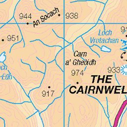
OS Map of Beinn Bhrotain
Height: 1157m / 3796ft • Prominence: 258m / 846ft • Summit : trig point • Trip reports (hill-bagging)

Beinn Bhrotain's boulder-field
On the west side of Beinn Bhrotain amongst the boulders, looking towards Braeriach, Sgòr an Lochain Uaine and Cairn Toul. Have to say, the hike out from Linn of Dee was starting to feel pretty remote by this point.
18-Sep-21 • OutdoorMonkey • flickr
sgòranlochainuaine cairntoul braeriach beinnbhrotain cairngorms outside outdoor rural nature natural scenic scenery mountain mountainside munro peak summit boulder boulders boulderfield sgoranlochainuaine wild wilderness remote 51550108026

Glen Geusachan & The Devil's Point
Sunshine on The Devil's Point, seen from somewhere near the bealach between Beinn Bhrotain and Monadh Mor. The peak on the very left is Cairn Toul, and the mountain left-of-centre in the distance is Ben Macdui.
18-Sep-21 • OutdoorMonkey • flickr
devilspoint glengeusachan valley mountain mountainside munro macdui bhrotain scotland outside outdoor rural nature natural scenic scenery landscape cairngorms sunshine sunlight 51551018310

Shoot Me Now!
Now we're down from Beinn Bhrotain, we're ready to start climbing again, and this is the wall that awaits us, along with Andy's reaction to it. It's been a tough day and it's just got tougher, but here goes nothing! Beinn Bhrotain (pronounced Bane Vrottan meaning Hill of the Hound) stands at 1157 meters (3796 feet) and is the first of our Munros today. Monadh Mor (pronounced Monnagh Mor meaning The Big Hill) is our second and final destination and stands at 1113 meters (3651 feet). A short 5 mile cycle up Glen Dee gets us to the foot of the climb, then it's an 11 mile hike across rough and boggy ground to get there. An epic 8.5 hours, largely un-pathed, time in the hills gets us back to the cars just before full dark falls!
27-Sep-20 • steve_whitmarsh • flickr
aberdeenshire scotland scottishhighlands highlands cairngorms mountain hills landscape monadhmor topic 50481197242

Snow Patches
After that steep climb, we are now reaching the plateau across which we have to walk to get to Monadh Mor. There was a fall of snow last night and despite the sun, it is now quite chilly and there's still remnants of it on the hill. Not much further now until we reach our final goal of Monadh Mor. Beinn Bhrotain (pronounced Bane Vrottan meaning Hill of the Hound) stands at 1157 meters (3796 feet) and is the first of our Munros today. Monadh Mor (pronounced Monnagh Mor meaning The Big Hill) is our second and final destination and stands at 1113 meters (3651 feet). A short 5 mile cycle up Glen Dee gets us to the foot of the climb, then it's an 11 mile hike across rough and boggy ground to get there. An epic 8.5 hours, largely un-pathed, time in the hills gets us back to the cars just before full dark falls!
27-Sep-20 • steve_whitmarsh • flickr
aberdeenshire scotland scottishhighlands highlands cairngorms mountain hills landscape rock rocks monadhmor snow topic rockpaper 50481048781

Beinn Bhrotain
From the summit of Monadh Mor we have a great view of the rocky upper slopes of Beinn Bhrotain, our first Munro summit of the day and are now heading back the way we've come as it was felt it would be too difficult trying to navigate the steep and boggy Glen Geusachan. Fortunately we don't have to go all the way over, the plan is just to traverse to the right of hit, minimising the amount of climbing we have to do. Zooming in you can make out the summit cairn which I've pictured in a previous post, to give an idea of scale! Beinn Bhrotain (pronounced Bane Vrottan meaning Hill of the Hound) stands at 1157 meters (3796 feet) and is the first of our Munros today. Monadh Mor (pronounced Monnagh Mor meaning The Big Hill) is our second and final destination and stands at 1113 meters (3651 feet). A short 5 mile cycle up Glen Dee gets us to the foot of the climb, then it's an 11 mile hike across rough and boggy ground to get there. An epic 8.5 hours, largely un-pathed, time in the hills gets us back to the cars just before full dark falls!
27-Sep-20 • steve_whitmarsh • flickr
aberdeenshire scotland scottishhighlands highlands cairngorms mountain hills landscape rock rocks beinnbhrotain monadhmor 50510050026

High Mountain Panoramic
From the high plateau before we reach the final summit of Monadh Mor (which is to our left), we have a great view of the massive Cairngorm Mountains. In sight here are the UKs 2nd, 3rd and 4th highest peaks, with only Ben Nevis being higher, and even then only by 30 meters! To the far right, we can see Beinn Bhrotain, our first Munro of the day that we've had to come up and over to get here, climbing from the bottom of Glen Dee below us. There are are number of Munros in sight here which I have picked out. Beinn Bhrotain (pronounced Bane Vrottan meaning Hill of the Hound) stands at 1157 meters (3796 feet) and is the first of our Munros today. Monadh Mor (pronounced Monnagh Mor meaning The Big Hill) is our second and final destination and stands at 1113 meters (3651 feet). A short 5 mile cycle up Glen Dee gets us to the foot of the climb, then it's an 11 mile hike across rough and boggy ground to get there. An epic 8.5 hours, largely un-pathed, time in the hills gets us back to the cars just before full dark falls!
27-Sep-20 • steve_whitmarsh • flickr
aberdeenshire scotland scottishhighlands highlands cairngorms mountain hills landscape panorama beinnbhrotain topic rockpaper 50489554738
OS Map
This is OS mapping. In some areas, OpenStreetMap shows more footpaths
Spatial NI has online OSNI mapping. Click "Basemap Gallery" (4 squares icon at the top).
Now would be a good time for a cup of tea.
GPX Editor
Record map clicks
Reload map
Photos
Please tag your photos and upload them to the British and Irish Mountains group on Flickr
The other photos have been geo-tagged as on or around the summit. For less busy mountains, it can be a little hit and miss.
Beinn Bhrotain's boulder-field
On the west side of Beinn Bhrotain amongst the boulders, looking towards Braeriach, Sgòr an Lochain Uaine and Cairn Toul. Have to say, the hike out from Linn of Dee was starting to feel pretty remote by this point.
18-Sep-21 • OutdoorMonkey • flickr
sgòranlochainuaine cairntoul braeriach beinnbhrotain cairngorms outside outdoor rural nature natural scenic scenery mountain mountainside munro peak summit boulder boulders boulderfield sgoranlochainuaine wild wilderness remote 51550108026
Glen Geusachan & The Devil's Point
Sunshine on The Devil's Point, seen from somewhere near the bealach between Beinn Bhrotain and Monadh Mor. The peak on the very left is Cairn Toul, and the mountain left-of-centre in the distance is Ben Macdui.
18-Sep-21 • OutdoorMonkey • flickr
devilspoint glengeusachan valley mountain mountainside munro macdui bhrotain scotland outside outdoor rural nature natural scenic scenery landscape cairngorms sunshine sunlight 51551018310
Shoot Me Now!
Now we're down from Beinn Bhrotain, we're ready to start climbing again, and this is the wall that awaits us, along with Andy's reaction to it. It's been a tough day and it's just got tougher, but here goes nothing! Beinn Bhrotain (pronounced Bane Vrottan meaning Hill of the Hound) stands at 1157 meters (3796 feet) and is the first of our Munros today. Monadh Mor (pronounced Monnagh Mor meaning The Big Hill) is our second and final destination and stands at 1113 meters (3651 feet). A short 5 mile cycle up Glen Dee gets us to the foot of the climb, then it's an 11 mile hike across rough and boggy ground to get there. An epic 8.5 hours, largely un-pathed, time in the hills gets us back to the cars just before full dark falls!
27-Sep-20 • steve_whitmarsh • flickr
aberdeenshire scotland scottishhighlands highlands cairngorms mountain hills landscape monadhmor topic 50481197242
Snow Patches
After that steep climb, we are now reaching the plateau across which we have to walk to get to Monadh Mor. There was a fall of snow last night and despite the sun, it is now quite chilly and there's still remnants of it on the hill. Not much further now until we reach our final goal of Monadh Mor. Beinn Bhrotain (pronounced Bane Vrottan meaning Hill of the Hound) stands at 1157 meters (3796 feet) and is the first of our Munros today. Monadh Mor (pronounced Monnagh Mor meaning The Big Hill) is our second and final destination and stands at 1113 meters (3651 feet). A short 5 mile cycle up Glen Dee gets us to the foot of the climb, then it's an 11 mile hike across rough and boggy ground to get there. An epic 8.5 hours, largely un-pathed, time in the hills gets us back to the cars just before full dark falls!
27-Sep-20 • steve_whitmarsh • flickr
aberdeenshire scotland scottishhighlands highlands cairngorms mountain hills landscape rock rocks monadhmor snow topic rockpaper 50481048781
Beinn Bhrotain
From the summit of Monadh Mor we have a great view of the rocky upper slopes of Beinn Bhrotain, our first Munro summit of the day and are now heading back the way we've come as it was felt it would be too difficult trying to navigate the steep and boggy Glen Geusachan. Fortunately we don't have to go all the way over, the plan is just to traverse to the right of hit, minimising the amount of climbing we have to do. Zooming in you can make out the summit cairn which I've pictured in a previous post, to give an idea of scale! Beinn Bhrotain (pronounced Bane Vrottan meaning Hill of the Hound) stands at 1157 meters (3796 feet) and is the first of our Munros today. Monadh Mor (pronounced Monnagh Mor meaning The Big Hill) is our second and final destination and stands at 1113 meters (3651 feet). A short 5 mile cycle up Glen Dee gets us to the foot of the climb, then it's an 11 mile hike across rough and boggy ground to get there. An epic 8.5 hours, largely un-pathed, time in the hills gets us back to the cars just before full dark falls!
27-Sep-20 • steve_whitmarsh • flickr
aberdeenshire scotland scottishhighlands highlands cairngorms mountain hills landscape rock rocks beinnbhrotain monadhmor 50510050026
High Mountain Panoramic
From the high plateau before we reach the final summit of Monadh Mor (which is to our left), we have a great view of the massive Cairngorm Mountains. In sight here are the UKs 2nd, 3rd and 4th highest peaks, with only Ben Nevis being higher, and even then only by 30 meters! To the far right, we can see Beinn Bhrotain, our first Munro of the day that we've had to come up and over to get here, climbing from the bottom of Glen Dee below us. There are are number of Munros in sight here which I have picked out. Beinn Bhrotain (pronounced Bane Vrottan meaning Hill of the Hound) stands at 1157 meters (3796 feet) and is the first of our Munros today. Monadh Mor (pronounced Monnagh Mor meaning The Big Hill) is our second and final destination and stands at 1113 meters (3651 feet). A short 5 mile cycle up Glen Dee gets us to the foot of the climb, then it's an 11 mile hike across rough and boggy ground to get there. An epic 8.5 hours, largely un-pathed, time in the hills gets us back to the cars just before full dark falls!
27-Sep-20 • steve_whitmarsh • flickr
aberdeenshire scotland scottishhighlands highlands cairngorms mountain hills landscape panorama beinnbhrotain topic rockpaper 50489554738

Rocky Highlands
Descending into the bealach between Monadh Mor and Beinn Bhrotain once again, the steep sides of Beinn Bhrotain can be seen to the right, and really shows just how desolate these upper highlands are. Beinn Bhrotain (pronounced Bane Vrottan meaning Hill of the Hound) stands at 1157 meters (3796 feet) and is the first of our Munros today. Monadh Mor (pronounced Monnagh Mor meaning The Big Hill) is our second and final destination and stands at 1113 meters (3651 feet). A short 5 mile cycle up Glen Dee gets us to the foot of the climb, then it's an 11 mile hike across rough and boggy ground to get there. An epic 8.5 hours, largely un-pathed, time in the hills gets us back to the cars just before full dark falls!
27-Sep-20 • steve_whitmarsh • flickr
mountain rock landscape scotland highlands rocks aberdeenshire hills cairngorms scottishhighlands monadhmor beinnbhrotain topic 50516886616

Shadow Play
Returning between Monadh Mor and Beinn Bhrotain (whose lower slopes are to the right), the sun is getting very low now and casting long shadows from Monadh Mor into Glen Geusachan, whose summit point is shadowed to the far left. Beyond we have the dramatic Devils Point with UKs 4th highest peak, Cairn Toul, to its left. Beyond, and rising above all is the UKs 2nd highest peak, Ben MacDui which is only 39 meters lower than Ben Nevis. Beinn Bhrotain (pronounced Bane Vrottan meaning Hill of the Hound) stands at 1157 meters (3796 feet) and is the first of our Munros today. Monadh Mor (pronounced Monnagh Mor meaning The Big Hill) is our second and final destination and stands at 1113 meters (3651 feet). A short 5 mile cycle up Glen Dee gets us to the foot of the climb, then it's an 11 mile hike across rough and boggy ground to get there. An epic 8.5 hours, largely un-pathed, time in the hills gets us back to the cars just before full dark falls!
27-Sep-20 • steve_whitmarsh • flickr
aberdeenshire scotland scottishhighlands highlands cairngorms mountain hills landscape glen beinnbhrotain monadhmor topic 50519135756

Stand Upon My Boulders
Skirting around Beinn Bhrotain to get back to the bikes, we have to navigate through this boulder field. Although It looks like a pebbly beach, some of these are the size of a coffee table .. and they wobble!! But we're nearly there now, after quite an epic 8 hours in the hills. Beinn Bhrotain (pronounced Bane Vrottan meaning Hill of the Hound) stands at 1157 meters (3796 feet) and is the first of our Munros today. Monadh Mor (pronounced Monnagh Mor meaning The Big Hill) is our second and final destination and stands at 1113 meters (3651 feet). A short 5 mile cycle up Glen Dee gets us to the foot of the climb, then it's an 11 mile hike across rough and boggy ground to get there. An epic 8.5 hours, largely un-pathed, time in the hills gets us back to the cars just before full dark falls!
27-Sep-20 • steve_whitmarsh • flickr
aberdeenshire scotland scottishhighlands highlands cairngorms mountain hills landscape blackandwhite bw monochrome rock rocks beinnbhrotain topic 50520697797

Marshy Highlands
Descending from Carn Clioch-mhuillin we refill our water bottles from a nice clear burn. However, this is the type of terrain we've been negotiating for most of the day, and some of it was hard going. But not long before we reach the bikes and the cars, so thank you all for joining me for what will probably be the last Munro climb of the year, there's simply not enough daylight to do them over winter! Beinn Bhrotain (pronounced Bane Vrottan meaning Hill of the Hound) stands at 1157 meters (3796 feet) and is the first of our Munros today. Monadh Mor (pronounced Monnagh Mor meaning The Big Hill) is our second and final destination and stands at 1113 meters (3651 feet). A short 5 mile cycle up Glen Dee gets us to the foot of the climb, then it's an 11 mile hike across rough and boggy ground to get there. An epic 8.5 hours, largely un-pathed, time in the hills gets us back to the cars just before full dark falls!
27-Sep-20 • steve_whitmarsh • flickr
aberdeenshire scotland scottishhighlands highlands cairngorms mountain hills landscape topic 50520523401
Videos
In today's video I will be climbing two munros in the heart of the Cairngorms.. Monadh Mor & Beinn Bhrotain THE ROUTE: ...
mountains #scotlandmountains #hiking #scottishadventure #scottishhighlands #snow #munrobagging #travel #beinnBhrotain ...
3rd April 2025.
Backpacking trip to Beinn Bhrotain in the Cairngorms national park approaching from the south with a high camp between its two ...
A weekend trip to the red house bothy in the cairngorms. we stayed the night in the bothy which was brilliant myself Paul Tam ...
Notes
- Data: Database of British and Irish Hills v18.2
- Maps: We use OS mapping for England, Scotland, Wales, and the Isle of Man. Sadly, Channel Islands, Northern (OSNI) and Southern Ireland (OSI) mapping isn't available online, so we use Openstreetmap.