Hills of Britain and Ireland
OS Map of Scout Scar


OS Map
This is OS mapping. In some areas, OpenStreetMap shows more footpaths
Spatial NI has online OSNI mapping. Click "Basemap Gallery" (4 squares icon at the top).
Now would be a good time for a cup of tea.
GPX Editor
Record map clicks
Reload map
Photos
Please tag your photos and upload them to the British and Irish Mountains group on Flickr
The other photos have been geo-tagged as on or around the summit. For less busy mountains, it can be a little hit and miss.


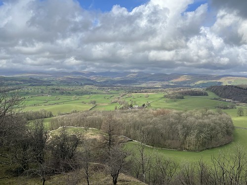
Lathe Valley
03-Mar-24 • Neal Anderson Photography • flickr
southern lake district cumbria langdale pikes green fields scout scar kendal 53621912880

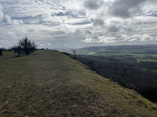
The Mushroom, Scout Scar, Kendal, Lake District National Park, Cumbria, UK
A cruciform, stone-built shelter is a reasonably common feature on summits in Northern England (and presumably elsewhere); whichever direction the wind blows, there's a lee side on which to, well, shelter. However, this example at the southern top of Scout Scar is unusual in having a domed roof, inspiring its local name. It was built in 1912 to commemorate the 1911 coronation of George V, and renovated in 1969 and 2003. The roof acts a toposcope identifying the Lakeland Fells and coastal features across Morecambe Bay. Scout Scar itself is a limestone escarpment rising gently from Kendal on its eastern side then plunging as a western cliff overlooking the Lyth Valley. The wind-scoured top undulates slightly, allowing a few stands of trees to develop on the limestone grassland. The Mushroom probably doesn't indicate the hill behind/to the right of it, as that's an anonymous 423 m point on Staveley Head Fell, 9.1 km from here. Likewise with the low hill to the left; that's Hollow Moor (426 m), 12 km away and east of Kentmere village. The more notable hill behind is Kentmere Pike (730 m), 15.8 away, with Shipman Knotts (587 m) 14.4 km away on its near-right. From Kentmere Pike the ground rises left to Harter Fell (778 m) 17½ km away, drops back to the col of the Nan Bield Pass then rises again towards Mardale Ill Bell. Rampsgill Head (792 m) is visible through the gap, 21.3 km away on High Street.
mushroom scoutscar kendal lakedistrict nationalpark cumbria uk kentmerepike harterfell summit shelter tree evening 53846499193
Videos
An afternoon walk over Cunswick and Scout Scars above Kendal. Wainwright descibed it as....A walk above all others, A pleasure ...
Please watch in FULL HD with sound... If you enjoyed the video or if you are just feeling generous? Why not buy me a coffee here: ...
Please watch in FULL HD with sound. Scout scar near Kendal.... Not the best day but wasn't going all that way not to fly. So here it ...
filmed with a DJI air 2s #djiair2s #DJI #kendal #drone #drones #dronesetc #sunset.
Idling time between gigs, me and Winnie took in a little fresh air. We're really looking forward to the new tourist season in the lakes ...
Notes
- Data: Database of British and Irish Hills v18.2
- Maps: We use OS mapping for England, Scotland, Wales, and the Isle of Man. Sadly, Channel Islands, Northern (OSNI) and Southern Ireland (OSI) mapping isn't available online, so we use Openstreetmap.