Hills of Britain and Ireland
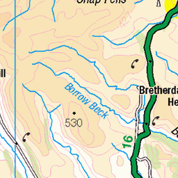
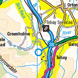
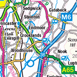
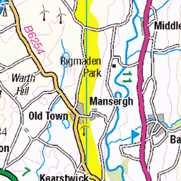
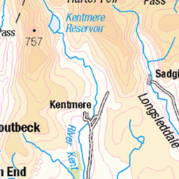
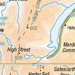
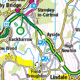
OS Map of Benson Knott
Height: 319m / 1047ft • Prominence: 133m / 436ft • Summit : no feature: ground 3m SE of cairn • Trip reports (hill-bagging)

LSL Saphos Trains 1Z31 'The Lakelander' Llandudno Junction to Carlisle 5th April 2025 Passing Meal Bank Nr Kendal on the WCML with A2 60532 'Blue Peter'©
Watch the Video at: www.youtube.com/watch?v=CncUpesY1qY&ab_channel=steamdriver12" rel="noreferrer nofollow www.youtube.com/watch?v=CncUpesY1qY&ab_channel=steamd...
05-Apr-25 • steamdriver12 • flickr
lsl saphos trains 1z31 the lakelander llandudno junction carlisle 5th april 2025 © 54432800080

2024-11-28 1622 Late train into Oxenholme
1h 10m late
28-Nov-24 • Houlie - Windermere • flickr
54170365056


Ice livery 88010 at Benson Hall
88010 'Aurora' climbs hard above Kendal with 4S43 06:25 Daventry to Mossend Tesco Express on Friday, 24th February 2023.
24-Feb-23 • phoenix.airimages • flickr
52708854014

Benson BIL
Making ‘light’ work of the Carlisle bound train, Bulleid designed ‘Merchant Navy’ 4-6-2 no.35018 'British India Line’ passes Benson Hall farm on the WCML with the RTC’s London Euston-Carlisle “Cumbrian Mountain Express”. Of note: In early 1956 ’British India Line’ was the first of the ’Merchant Navy’ class locomotives to be rebuilt from the original 'SpamCan' design.
06-Aug-22 • 4486Merlin • flickr
england europe northwest 35018 exsr britishindialine unitedkingdom transport steam cumbria railways kendal wcml srmerchantnavyclass rtc wcrc cumbrianmountainexpress 52269448090

IMGP4108
View west from the West Coast Main Line near Kendal.
13-May-22 • mattbuck4950 • flickr
england unitedkingdom europe photosbymatt camerapentaxk70 lenssigma18300mm railways mainlinerailways ontrainphotos 2022 may westcoastmainline cumbria lakedistrict kendal 52351727647
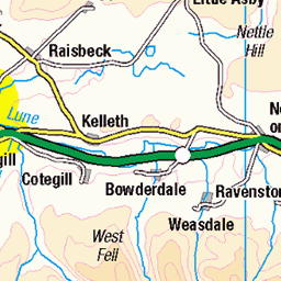
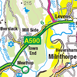
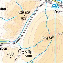
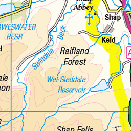
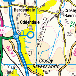
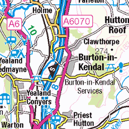
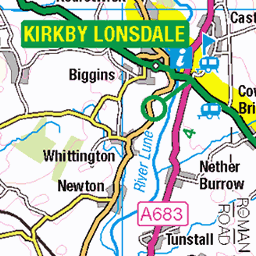
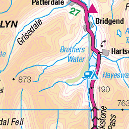
OS Map
This is OS mapping. In some areas, OpenStreetMap shows more footpaths
Spatial NI has online OSNI mapping. Click "Basemap Gallery" (4 squares icon at the top).
Now would be a good time for a cup of tea.
GPX Editor
Record map clicks
Reload map
Photos
Please tag your photos and upload them to the British and Irish Mountains group on Flickr
The other photos have been geo-tagged as on or around the summit. For less busy mountains, it can be a little hit and miss.
LSL Saphos Trains 1Z31 'The Lakelander' Llandudno Junction to Carlisle 5th April 2025 Passing Meal Bank Nr Kendal on the WCML with A2 60532 'Blue Peter'©
Watch the Video at: www.youtube.com/watch?v=CncUpesY1qY&ab_channel=steamdriver12" rel="noreferrer nofollow www.youtube.com/watch?v=CncUpesY1qY&ab_channel=steamd...
05-Apr-25 • steamdriver12 • flickr
lsl saphos trains 1z31 the lakelander llandudno junction carlisle 5th april 2025 © 54432800080
2024-11-28 1622 Late train into Oxenholme
1h 10m late
28-Nov-24 • Houlie - Windermere • flickr
54170365056
Ice livery 88010 at Benson Hall
88010 'Aurora' climbs hard above Kendal with 4S43 06:25 Daventry to Mossend Tesco Express on Friday, 24th February 2023.
24-Feb-23 • phoenix.airimages • flickr
52708854014
Benson BIL
Making ‘light’ work of the Carlisle bound train, Bulleid designed ‘Merchant Navy’ 4-6-2 no.35018 'British India Line’ passes Benson Hall farm on the WCML with the RTC’s London Euston-Carlisle “Cumbrian Mountain Express”. Of note: In early 1956 ’British India Line’ was the first of the ’Merchant Navy’ class locomotives to be rebuilt from the original 'SpamCan' design.
06-Aug-22 • 4486Merlin • flickr
england europe northwest 35018 exsr britishindialine unitedkingdom transport steam cumbria railways kendal wcml srmerchantnavyclass rtc wcrc cumbrianmountainexpress 52269448090
IMGP4108
View west from the West Coast Main Line near Kendal.
13-May-22 • mattbuck4950 • flickr
england unitedkingdom europe photosbymatt camerapentaxk70 lenssigma18300mm railways mainlinerailways ontrainphotos 2022 may westcoastmainline cumbria lakedistrict kendal 52351727647

IMGP4112
View west from the West Coast Main Line near Kendal.
13-May-22 • mattbuck4950 • flickr
england unitedkingdom europe photosbymatt camerapentaxk70 lenssigma18300mm railways mainlinerailways ontrainphotos 2022 may westcoastmainline cumbria lakedistrict kendal 52352992584

LSL Intercity 1Z59 'The Clansman' railtour with AC 25KV Electric 87002 'Royal Sovereign' heads north passing mile post 22¼ at Paddy Lane Meal Bank near Kendal on 26th February 2022 ©
Watch the Video at www.youtube.com/watch?v=INnTLH0ljGQ&ab_channel=steamdriver12" rel="noreferrer nofollow www.youtube.com/watch?v=INnTLH0ljGQ&ab_channel=steamd...
26-Feb-22 • steamdriver12 • flickr
lsl locomotive services limited intercity 1z59 the clansman railtour heads north mile post 22¼ paddy lane meal bank kendal 26th february 2022 ac 25kv electric 87002 51904776212

11377 - Laverock, Railway Bridge
SD 5427 9533, LR97. HISTORY Flush bracket 11377 was emplaced around 1969. It was included on secondary levelling line SD15 during 1969. The surveyor's description was S parapet, Laverock Bridge, 7m W of hedge junction. This marker was last verified in 1970. The OS Online Archive gives the description "A685, S parapet of bridge over railway, 7m W from hedge junction". SITE VISIT BM 137.71m. The flush bracket is at the east end of the south parapet facing across the road. Convenient layby by west end of bridge, south side of road. Public roadside access. The bracket is in good condition. Photographed 17th September 2017, GRP. ════════════════════════════════════ BMD: www.bench-marks.org.uk/bm22205" rel="noreferrer nofollow www.bench-marks.org.uk/bm ════════════════════════════════════ Neighbouring Flush Brackets S7965 - Skelsmergh, Church Hall : 0.82 miles west. (X) www.flickr.com/photos/13460108@N06/52682422672/in/album-72157662462414430/ S6749 - Kendal, County Hall : 2.21 miles to the SW. www.flickr.com/photos/13460108@N06/52685344355/in/album-72157662462414430/ S0231 - Kendal, Mason Arms : 2.26 miles to the SW. www.flickr.com/photos/13460108@N06/52685343525/in/album-72157662462414430/ S6744 - Kendal, Post Office : 2.27 miles to the SW. www.flickr.com/photos/13460108@N06/52683221464/in/album-72157662462414430/ S6750 - Burneside, Church : 2.37 miles to the west. 11378 - Grayrigg, Vicarage : 2.45 miles to the NE. (X) www.flickr.com/photos/13460108@N06/52685418653/in/album-72157662462414430/ S6073 - Kendal, All Hallows Lane : 2.47 miles to the SW. S7966 - North Gateside : 2.73 miles to the north. (X) - - - - - - - - - - - - - - - - - - - - - - - -- (X) = destroyed) ════════════════════════════════════ Nearest Triangulation Pillar www.flickr.com/photos/13460108@N06/8176769052/in/album-72157631778814317/ S5733 - Benson Knott : 0.80 miles to the south. ════════════════════════════════════
17-Sep-17 • Graeme5015 • flickr
11377 osbm laverock mealbank scalthwaiterigg 52684406847

Southbound HST On Grayrigg.
43099 descends Grayrigg at Meal Bank with 1V52 08:50 Edinburgh to Penzance. 22/5/93.
22-May-93 • Neil Harvey 156 • flickr
railway 43099 mealbank kendal grayrigg westcoastmainline wcml 1v52 class43 hst intercitylivery intercityswallow intercity125 52070610255
Videos
None found
Notes
- Data: Database of British and Irish Hills v18.2
- Maps: We use OS mapping for England, Scotland, Wales, and the Isle of Man. Sadly, Channel Islands, Northern (OSNI) and Southern Ireland (OSI) mapping isn't available online, so we use Openstreetmap.