Hills of Britain and Ireland
OS Map of Cairngryffe Hill (quarried)
Height: 331m / 1084ft • Prominence: 109m / 358ft • Summit : no feature • Trip reports (hill-bagging)

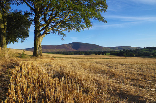
Late summer in Clydesdale
The harvest is in, the trees have turned a dark green and the hills are tinged with purple heather in flower in this view of Tinto Hill from Blackshouse Farm.
26-Aug-14 • Mike Futty • flickr
44718821892


S3601 - Cairngryfe Hill (destroyed)
NS942412, LR71 & 72. HISTORY Pillar completed early 1946, exact details not on record. Computed as secondary trangulation station NS77/S5 within the Glasgow block during 1946. This station was also used for the reconnaissance of secondary block NS83 (Lanark) during 1950. Levelled for height to first class precision, tertiary standards in 1967. Last maintained by the OS in 1971. Recorded destroyed in July 1993 although it had gone by October 1992. SITE VISIT Every trigger / trigonomist's nightmare, a missing trig pillar. Somewhere out there in front stood trig pillar S3601. When I visited, not only was the trig pillar missing but much of Cairngryfe Hill was missing too, but according to the maps and records the demise was recent at the time. The picture tells the rest of the story. The large distant hill in the top right of the picture is Tinto, another trig (S8052) with a colourful history although still extant. Photographed: 7th October 1992, GRP. ═════════════════════════ Interactive index: www.google.com/maps/d/viewer?mid=1arx2Qmo5mVeVUJA2lzVG_uzbYPW59ffh&ll=55.653472,-3.681834&z=12" rel="noreferrer nofollow Google My Maps Map: www.flickr.com/photos/13460108@N06/41647376710/in/album-72157692190778971/ Trig Pillars on OS Landranger 71 Map: www.flickr.com/photos/13460108@N06/43496070241/in/album-72157692190778971/ Trig Pillars on OS Landranger 72 ═════════════════════════ Neighbouring Triangulation Pillars www.flickr.com/photos/13460108@N06/8103187901/in/album-72157631778814317/ S5584 - Libberton Mains : 3.33 miles to the ENE www.flickr.com/photos/13460108@N06/8103203058/in/album-72157631778814317/ S5460 - Quothquan Law : 3.34 miles to the ESE www.flickr.com/photos/13460108@N06/8103189821/in/album-72157631778814317/ S5411 - Black Hill North : 3.51 miles to the SSW S3603 - Lang Hill : 3.66 miles to the north. (X) www.flickr.com/photos/13460108@N06/8109884701/in/album-72157631821839859/ S8052 - Tinto : 4.34 miles to the south. www.flickr.com/photos/13460108@N06/8103189205/in/album-72157631778814317/ S5458 - Symington Mill : 5.37 miles to the southeast. www.flickr.com/photos/13460108@N06/7972497480/in/album-72157631347423092/ S3583 - Kilncadzow Law : 5.74 miles to the northwest. ═════════════════════════ Nearest Non Pillar Flush Bracket (Levelling Line) www.flickr.com/photos/13460108@N06/24579299422/in/album-72157662157184532/ G460 - Bowhouse : 1.80 miles to the south. ═════════════════════════
07-Oct-92 • Graeme5015 • flickr
s3601 3601 pettinain 51877933619
OS Map
This is OS mapping. In some areas, OpenStreetMap shows more footpaths
Spatial NI has online OSNI mapping. Click "Basemap Gallery" (4 squares icon at the top).
Now would be a good time for a cup of tea.


GPX Editor
Record map clicks
Reload map
Photos
Please tag your photos and upload them to the British and Irish Mountains group on Flickr
The other photos have been geo-tagged as on or around the summit. For less busy mountains, it can be a little hit and miss.

Late summer in Clydesdale
The harvest is in, the trees have turned a dark green and the hills are tinged with purple heather in flower in this view of Tinto Hill from Blackshouse Farm.
26-Aug-14 • Mike Futty • flickr
44718821892


S3601 - Cairngryfe Hill (destroyed)
NS942412, LR71 & 72. HISTORY Pillar completed early 1946, exact details not on record. Computed as secondary trangulation station NS77/S5 within the Glasgow block during 1946. This station was also used for the reconnaissance of secondary block NS83 (Lanark) during 1950. Levelled for height to first class precision, tertiary standards in 1967. Last maintained by the OS in 1971. Recorded destroyed in July 1993 although it had gone by October 1992. SITE VISIT Every trigger / trigonomist's nightmare, a missing trig pillar. Somewhere out there in front stood trig pillar S3601. When I visited, not only was the trig pillar missing but much of Cairngryfe Hill was missing too, but according to the maps and records the demise was recent at the time. The picture tells the rest of the story. The large distant hill in the top right of the picture is Tinto, another trig (S8052) with a colourful history although still extant. Photographed: 7th October 1992, GRP. ═════════════════════════ Interactive index: www.google.com/maps/d/viewer?mid=1arx2Qmo5mVeVUJA2lzVG_uzbYPW59ffh&ll=55.653472,-3.681834&z=12" rel="noreferrer nofollow Google My Maps Map: www.flickr.com/photos/13460108@N06/41647376710/in/album-72157692190778971/ Trig Pillars on OS Landranger 71 Map: www.flickr.com/photos/13460108@N06/43496070241/in/album-72157692190778971/ Trig Pillars on OS Landranger 72 ═════════════════════════ Neighbouring Triangulation Pillars www.flickr.com/photos/13460108@N06/8103187901/in/album-72157631778814317/ S5584 - Libberton Mains : 3.33 miles to the ENE www.flickr.com/photos/13460108@N06/8103203058/in/album-72157631778814317/ S5460 - Quothquan Law : 3.34 miles to the ESE www.flickr.com/photos/13460108@N06/8103189821/in/album-72157631778814317/ S5411 - Black Hill North : 3.51 miles to the SSW S3603 - Lang Hill : 3.66 miles to the north. (X) www.flickr.com/photos/13460108@N06/8109884701/in/album-72157631821839859/ S8052 - Tinto : 4.34 miles to the south. www.flickr.com/photos/13460108@N06/8103189205/in/album-72157631778814317/ S5458 - Symington Mill : 5.37 miles to the southeast. www.flickr.com/photos/13460108@N06/7972497480/in/album-72157631347423092/ S3583 - Kilncadzow Law : 5.74 miles to the northwest. ═════════════════════════ Nearest Non Pillar Flush Bracket (Levelling Line) www.flickr.com/photos/13460108@N06/24579299422/in/album-72157662157184532/ G460 - Bowhouse : 1.80 miles to the south. ═════════════════════════
07-Oct-92 • Graeme5015 • flickr
s3601 3601 pettinain 51877933619
Videos
None found
Notes
- Data: Database of British and Irish Hills v18.2
- Maps: We use OS mapping for England, Scotland, Wales, and the Isle of Man. Sadly, Channel Islands, Northern (OSNI) and Southern Ireland (OSI) mapping isn't available online, so we use Openstreetmap.