Hills of Britain and Ireland
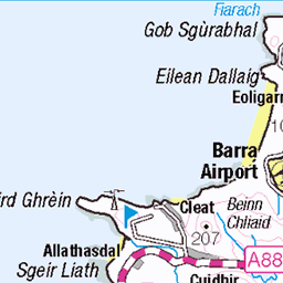
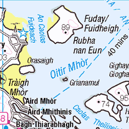
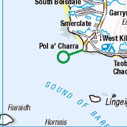
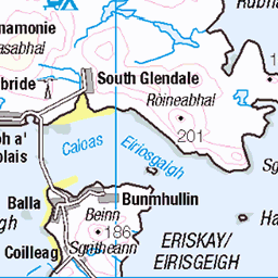
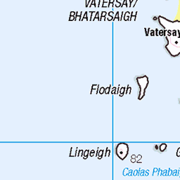
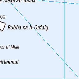
OS Map of Grianan
Height: 295m / 968ft • Prominence: 131m / 430ft • Summit : small cairn • Trip reports (hill-bagging)

Barra Hebridean Way near Corra Bheinn
15-Sep-22 • Geoff Buck • flickr
outerhebrides hebrides scotland island islands barra hebrideanway 52544497745

Barra Hebridean Way Beinn Bhirsig
15-Sep-22 • Geoff Buck • flickr
outerhebrides hebrides scotland island islands barra hebrideanway 52543552327

Barra Hebridean Way Golf Club and Cnoc an Fhithich
15-Sep-22 • Geoff Buck • flickr
outerhebrides hebrides scotland island islands barra hebrideanway 52544498240

Barra Hebridean Way Borve Borgh
15-Sep-22 • Geoff Buck • flickr
outerhebrides hebrides scotland island islands barra hebrideanway 52544498455

Barra Hebridean Way restored farmhouse at Craigston Baile na Creige 2
15-Sep-22 • Geoff Buck • flickr
outerhebrides hebrides scotland island islands barra hebrideanway shieling 52544562608
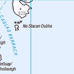
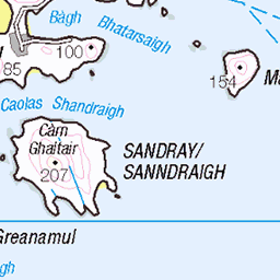
OS Map
This is OS mapping. In some areas, OpenStreetMap shows more footpaths
Spatial NI has online OSNI mapping. Click "Basemap Gallery" (4 squares icon at the top).
Now would be a good time for a cup of tea.


GPX Editor
Record map clicks
Reload map
Photos
Please tag your photos and upload them to the British and Irish Mountains group on Flickr
The other photos have been geo-tagged as on or around the summit. For less busy mountains, it can be a little hit and miss.
Barra Hebridean Way near Corra Bheinn
15-Sep-22 • Geoff Buck • flickr
outerhebrides hebrides scotland island islands barra hebrideanway 52544497745
Barra Hebridean Way Beinn Bhirsig
15-Sep-22 • Geoff Buck • flickr
outerhebrides hebrides scotland island islands barra hebrideanway 52543552327
Barra Hebridean Way Golf Club and Cnoc an Fhithich
15-Sep-22 • Geoff Buck • flickr
outerhebrides hebrides scotland island islands barra hebrideanway 52544498240
Barra Hebridean Way Borve Borgh
15-Sep-22 • Geoff Buck • flickr
outerhebrides hebrides scotland island islands barra hebrideanway 52544498455
Barra Hebridean Way restored farmhouse at Craigston Baile na Creige 2
15-Sep-22 • Geoff Buck • flickr
outerhebrides hebrides scotland island islands barra hebrideanway shieling 52544562608


4978 Grianan
View towards the HuMP called Grianan
06-May-14 • Dugswell2 • flickr
barra hump grianan p131 14025642459

4978 Grianan 1
Bagged with Iain Brown and Martin Richardson, on a mild morning with rain on the summit. Name:Grianan Hill number:4978 Height:295m / 968ft Parent (Ma/M):1627 Sheabhal [Heaval] Area:24D: Barra to Barra Head Class:Hu,2 Grid ref: NF 68125 01525 Summit feature:small cairn Drop:131m Col:164m NF684008
06-May-14 • Dugswell2 • flickr
barra hump grianan p131 14212154674

4978 Grianan 2
Bagged with Iain Brown and Martin Richardson, on a mild morning with rain on the summit. Name:Grianan Hill number:4978 Height:295m / 968ft Parent (Ma/M):1627 Sheabhal [Heaval] Area:24D: Barra to Barra Head Class:Hu,2 Grid ref: NF 68125 01525 Summit feature:small cairn Drop:131m Col:164m NF684008
06-May-14 • Dugswell2 • flickr
barra hump grianan p131 14232494153

Thartabhal
Canon EOS 50D, Canon EF 17-40mm f/4L USM, processed in Canon software and in Lightroom. Typical Heridean walking.
19-May-11 • Ed Fulton • flickr
scotland unitedkingdom lesley barra westernisles canonef1740mmf4lusm hebrides canoneos50d barraigh naheileanananiar point360 thartabhal 52631727982

From Thartabhal
Canon EOS 50D, Canon EF 17-40mm f/4L USM, processed in Canon software and in Lightroom.
19-May-11 • Ed Fulton • flickr
barra barraigh canonef1740mmf4lusm canoneos50d hebrides naheileanananiar scotland thartabhal westernisles unitedkingdom 52634304101

Thartabhal summit panorama
Canon EOS 50D, Canon EF 17-40mm f/4L USM, a panorama from seven original shots, processed in Canon software, Photoshop and in Lightroom.
19-May-11 • Ed Fulton • flickr
scotland unitedkingdom barra westernisles hebrides canoneos50d barraigh naheileanananiar thartabhal canonef1740mmf4lusm 52634786363

Sheabhal from Thartabhal
Canon EOS 50D, Canon EF 17-40mm f/4L USM, processed in Canon software and in Lightroom.
19-May-11 • Ed Fulton • flickr
barra barraigh canonef1740mmf4lusm canoneos50d hebrides naheileanananiar scotland thartabhal westernisles unitedkingdom 52632721363
Videos
None found
Notes
- Data: Database of British and Irish Hills v18.2
- Maps: We use OS mapping for England, Scotland, Wales, and the Isle of Man. Sadly, Channel Islands, Northern (OSNI) and Southern Ireland (OSI) mapping isn't available online, so we use Openstreetmap.