Hills of Britain and Ireland
OS Map of Beinn Bhuidhe

El Toro
We see lots of Highland cows (as in females) or coos, but not many Highland bulls in their natural and wild environment. That's Dirk, looking on from afar, and I know he's a bull, and he fancies Gertrude, more to come shortly. We've met before, up close and personal. Close enough for me to feel how hot his horns were on a frosty morning.
18-Mar-23 • PentlandPirate: Slapdash Photography • flickr
highland cow bull cattle ardnamurchan scotland highlands 52755715109


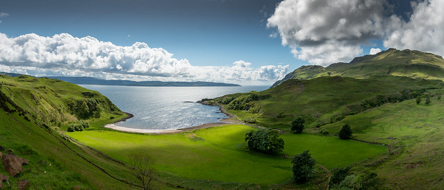
Camas nan Gaell and Ben Hiant
Take a trip out to Sanna Bay and pass the bay we know as Camas nan Geall which has been occupied for at least 5,000 years, since Neolithic times. The chambered cairn is of this age, while the standing stone by Cladh Chiarain, the Campbell graveyard, is assigned to the Bronze Age (4,000 years ago), although it was later engraved with images including a Christian cross and, above it, what may be a dog. These carvings may date to the time of the coming of St Columba, after he began his west coast journeys in 563AD and founded the abbey at Iona. At the roadside 200m east of the car park, water from a spring, known locally as Tobar Chalum Chille (tobar well, Colum Columba, cille church or cell), falls across a stone wall. Towards the end of the 8th century the Vikings arrived on this coast, first as raiders and later to settle. It is inconceivable that they did not use this protected haven to pull up their longships, yet evidence of Viking occupation has yet to be found. Further, the name is not Norse, though the meaning of the Gaelic is disputed – the bay of the stranger, the bay of the pledge, promise or wager, and the bay of the churches are all suggested.In the hundreds of years following the absorption of the Vikings into the population, both the bay area and the rough area to the northwest of the bay were occupied by a small communally-run settlement. We know little about the early history of this community but we do know that, during the Lordship of the Isles, it was part of the lands of the Clan MacIain. This clan held Ardnamurchan and Mingary Castle from the early 14th until the early 17th century. Camas nan Geall would have been little different from the twenty-three other settlements within the clan’s lands in Ardnamurchan. Each had inbye land – arable land close to the houses – where crops were grown, and extensive common grazings which were used for summer pastures. In Camas nan Geall’s case, the common grazings extended north as far as Loch Mudle. The settlement contributed, mainly in the form of agricultural produce, to the upkeep of the MacIain chief and his retinue, and provided men for the clan’s army in times of war. In 1541 the principal tenant was Donald McAlister McKane and, in 1618, at the time when the MacIains were losing their lands to the Campbell Dukes of Argyll, the principal tenant of Camas nan Geall was Alexander McRonald McEane, while in 1686 it was held by Donald and Anna Cameron and Neill McOnlea. Following the suppression of the Jacobite rising of 1715, a record was kept of the men of each settlement who were called to surrender their arms at Mingary Castle in April 1716. Since men from both sides of the conflict had to attend, the nine men listed from Camas nan Geall give us some idea of the settlement’s population. In 1737 Camas nan Geall was in the hands of Alexander Campbell of Ardslignish, who raised at least two of the gravestones in Cladh Chiarain. From records prepared in the same year for Alexander Murray, Lord Stanhope, to whom the Duke of Argyll had sold Ardnamurchan, we know the settlement had a population of 35 – 9 men, 13 women and 13 children – with approximately 72 cattle, 72 sheep and 18 horses. By the mid-1700s, when William Roy drew his ‘military map’ , there were no houses in use in the rough ground to the northwest of the big field, and only a few in the area to the south of the neolithic cairn. This suggests that much of the settlement had already been cleared while the land was being worked by Alexander Campbell as a tenant farm. A square is marked, perhaps a wall, surrounded by trees, with a large building at its southern end. This may have been the Campbell’s dwelling, which some have suggested was called ‘Tigh Ban’, the white house, which further suggests it may have been harled and whitewashed. Ben Hiant is the flank of a volcano, formed around 60 million years ago, and a very visible remnant of the volcanic make-up of the Ardnamurchan peninsula
24-May-22 • PentlandPirate: Slapdash Photography • flickr
camasnangaell ardnamurchan scotland highlands camasnangeall 52095654147

The Highland Bull
The Spanish think they know a thing or two about this but I didn't even have a cape, let alone a sword. Close up and personal. I think we have an understanding: "I'll be nice to you if you don't charge me down before I can get back to the gate, and gore and trample me to death"
17-Dec-21 • PentlandPirate: Slapdash Photography • flickr
highland coo bull highlands scotland ardnamurchan 51752552272

OS Map
This is OS mapping. In some areas, OpenStreetMap shows more footpaths
Spatial NI has online OSNI mapping. Click "Basemap Gallery" (4 squares icon at the top).
Now would be a good time for a cup of tea.
GPX Editor
Record map clicks
Reload map
Photos
Please tag your photos and upload them to the British and Irish Mountains group on Flickr
The other photos have been geo-tagged as on or around the summit. For less busy mountains, it can be a little hit and miss.
El Toro
We see lots of Highland cows (as in females) or coos, but not many Highland bulls in their natural and wild environment. That's Dirk, looking on from afar, and I know he's a bull, and he fancies Gertrude, more to come shortly. We've met before, up close and personal. Close enough for me to feel how hot his horns were on a frosty morning.
18-Mar-23 • PentlandPirate: Slapdash Photography • flickr
highland cow bull cattle ardnamurchan scotland highlands 52755715109
Camas nan Gaell and Ben Hiant
Take a trip out to Sanna Bay and pass the bay we know as Camas nan Geall which has been occupied for at least 5,000 years, since Neolithic times. The chambered cairn is of this age, while the standing stone by Cladh Chiarain, the Campbell graveyard, is assigned to the Bronze Age (4,000 years ago), although it was later engraved with images including a Christian cross and, above it, what may be a dog. These carvings may date to the time of the coming of St Columba, after he began his west coast journeys in 563AD and founded the abbey at Iona. At the roadside 200m east of the car park, water from a spring, known locally as Tobar Chalum Chille (tobar well, Colum Columba, cille church or cell), falls across a stone wall. Towards the end of the 8th century the Vikings arrived on this coast, first as raiders and later to settle. It is inconceivable that they did not use this protected haven to pull up their longships, yet evidence of Viking occupation has yet to be found. Further, the name is not Norse, though the meaning of the Gaelic is disputed – the bay of the stranger, the bay of the pledge, promise or wager, and the bay of the churches are all suggested.In the hundreds of years following the absorption of the Vikings into the population, both the bay area and the rough area to the northwest of the bay were occupied by a small communally-run settlement. We know little about the early history of this community but we do know that, during the Lordship of the Isles, it was part of the lands of the Clan MacIain. This clan held Ardnamurchan and Mingary Castle from the early 14th until the early 17th century. Camas nan Geall would have been little different from the twenty-three other settlements within the clan’s lands in Ardnamurchan. Each had inbye land – arable land close to the houses – where crops were grown, and extensive common grazings which were used for summer pastures. In Camas nan Geall’s case, the common grazings extended north as far as Loch Mudle. The settlement contributed, mainly in the form of agricultural produce, to the upkeep of the MacIain chief and his retinue, and provided men for the clan’s army in times of war. In 1541 the principal tenant was Donald McAlister McKane and, in 1618, at the time when the MacIains were losing their lands to the Campbell Dukes of Argyll, the principal tenant of Camas nan Geall was Alexander McRonald McEane, while in 1686 it was held by Donald and Anna Cameron and Neill McOnlea. Following the suppression of the Jacobite rising of 1715, a record was kept of the men of each settlement who were called to surrender their arms at Mingary Castle in April 1716. Since men from both sides of the conflict had to attend, the nine men listed from Camas nan Geall give us some idea of the settlement’s population. In 1737 Camas nan Geall was in the hands of Alexander Campbell of Ardslignish, who raised at least two of the gravestones in Cladh Chiarain. From records prepared in the same year for Alexander Murray, Lord Stanhope, to whom the Duke of Argyll had sold Ardnamurchan, we know the settlement had a population of 35 – 9 men, 13 women and 13 children – with approximately 72 cattle, 72 sheep and 18 horses. By the mid-1700s, when William Roy drew his ‘military map’ , there were no houses in use in the rough ground to the northwest of the big field, and only a few in the area to the south of the neolithic cairn. This suggests that much of the settlement had already been cleared while the land was being worked by Alexander Campbell as a tenant farm. A square is marked, perhaps a wall, surrounded by trees, with a large building at its southern end. This may have been the Campbell’s dwelling, which some have suggested was called ‘Tigh Ban’, the white house, which further suggests it may have been harled and whitewashed. Ben Hiant is the flank of a volcano, formed around 60 million years ago, and a very visible remnant of the volcanic make-up of the Ardnamurchan peninsula
24-May-22 • PentlandPirate: Slapdash Photography • flickr
camasnangaell ardnamurchan scotland highlands camasnangeall 52095654147
The Highland Bull
The Spanish think they know a thing or two about this but I didn't even have a cape, let alone a sword. Close up and personal. I think we have an understanding: "I'll be nice to you if you don't charge me down before I can get back to the gate, and gore and trample me to death"
17-Dec-21 • PentlandPirate: Slapdash Photography • flickr
highland coo bull highlands scotland ardnamurchan 51752552272


Loch Sunart, Ardnamurchan, Scotland.
My Wife gazes across “Loch Sunart” from Ardslignish on the Ardnamurchan Peninsula to the Isle’s of Oronsay and Carna with Loch Teacuis in the far distance. Loch Sunart is a long narrow sea loch that stretches inland for 31km (19miles) and separates the Ardnamurchan and Morvern Peninsulas on the west coast of Scotland. The fresh clear sea water make it perfect for diving and spotting Otters, Seals and Porpoise while it’s wooded shoreline abounds with wildlife, all in all a great place to visit.
15-Aug-19 • The Jacobite • flickr
scotland loch sea inland sunart islands ardnamurchan peninsula seawater canon760d mountains shoreline 50147439326

Videos
None found
Notes
- Data: Database of British and Irish Hills v18.2
- Maps: We use OS mapping for England, Scotland, Wales, and the Isle of Man. Sadly, Channel Islands, Northern (OSNI) and Southern Ireland (OSI) mapping isn't available online, so we use Openstreetmap.