Hills of Britain and Ireland
OS Map of Beinn Rosail
Height: 260m / 853ft • Prominence: 102m / 335ft • Summit : square rock 15m SSW of cairn • Trip reports (hill-bagging)


Rosal 1
A few piles of stones are all that remain of the 70 houses at the infamous 'clearance village' of Rosal, Strathnaver in Sutherland.
01-Sep-21 • nickjquinn • flickr
rosal scotland sutherland strathnaver 51475940099
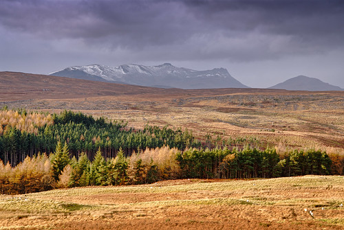
Ben Loyal from Rosal Clearance village
A tale of contrasts: sky and earth mankind's usage of the land from crofting to run-rig style farming to monoculture forestry fertile and barren warm light and dull cold
nature art composition places scotland highlands contrasts landscape mountains rawconversion dcraw flora trees light vista manipulated composite enfuse lightanddark photography equipment camera sunlight brightsunlight hdr pentaxk1 lens pentax28105mm digikam tonemapped toned people sky clouds heritage history colour colourful brightglowingcolour rules serifaffinityphoto sutherland photolemur strathnaver rosal scottishhighlandclearances clearancevillage distance nearmidfardistance politics ecologyenvironmentinteraction industry settlement village filthycloud farming conifer hamlet township benloyal hill mountain beinnloyal warm cold mankindnature goodbad 41342801022
OS Map
This is OS mapping. In some areas, OpenStreetMap shows more footpaths
Spatial NI has online OSNI mapping. Click "Basemap Gallery" (4 squares icon at the top).
Now would be a good time for a cup of tea.
GPX Editor
Record map clicks
Reload map
Photos
Please tag your photos and upload them to the British and Irish Mountains group on Flickr
The other photos have been geo-tagged as on or around the summit. For less busy mountains, it can be a little hit and miss.
Rosal 1
A few piles of stones are all that remain of the 70 houses at the infamous 'clearance village' of Rosal, Strathnaver in Sutherland.
01-Sep-21 • nickjquinn • flickr
rosal scotland sutherland strathnaver 51475940099
Ben Loyal from Rosal Clearance village
A tale of contrasts: sky and earth mankind's usage of the land from crofting to run-rig style farming to monoculture forestry fertile and barren warm light and dull cold
nature art composition places scotland highlands contrasts landscape mountains rawconversion dcraw flora trees light vista manipulated composite enfuse lightanddark photography equipment camera sunlight brightsunlight hdr pentaxk1 lens pentax28105mm digikam tonemapped toned people sky clouds heritage history colour colourful brightglowingcolour rules serifaffinityphoto sutherland photolemur strathnaver rosal scottishhighlandclearances clearancevillage distance nearmidfardistance politics ecologyenvironmentinteraction industry settlement village filthycloud farming conifer hamlet township benloyal hill mountain beinnloyal warm cold mankindnature goodbad 41342801022
Videos
None found
Notes
- Data: Database of British and Irish Hills v18.2
- Maps: We use OS mapping for England, Scotland, Wales, and the Isle of Man. Sadly, Channel Islands, Northern (OSNI) and Southern Ireland (OSI) mapping isn't available online, so we use Openstreetmap.