Hills of Britain and Ireland
OS Map of Beinn Dearg Bad Chailleach

S7669 - Bad Chailleach
NG912876, LR19. HISTORY Pillar completed 15th February 1955 costing £45.19s.0d. Computed as secondary triangulation station NC20/1 within the Ullapool secondary block, and levelled to second class precision during 1955. This pillar station was last maintained by the Ordnance Survey in May 1980. SITE VISIT Overall approach from the west, Drumchork. From roadhead at NG879884, a track leads into the hills passing a covered cistern then for around 600m this track runs parallel to the perimeter fence of an oil depot. Continued on this track until around NG897874, then keeping north of Loch na Claise Carnaich, started to climb the rough boggy terrain towards the main hill. When nearer to the hill it is apparent that the rocks on the west side are sheer, so the final ascent to the summit was from the south. Open grazing hill alternatively named Beinn Dearg. The pillar is in good condition. The spider centre is open. The flush bracket faces north, compass measurement 11°. Vented through the left sight hole, the back port is starting to break open. Full 360° panoramic outlook to the surrounding hills, lochs and coastline. Photographed: 10th August 2022, GRP. ═════════════════════════ Interactive index: www.google.com/maps/d/viewer?mid=1arx2Qmo5mVeVUJA2lzVG_uzbYPW59ffh&ll=57.829830,-5.516958&z=11" rel="noreferrer nofollow Google My Maps Map: www.flickr.com/photos/13460108@N06/50432937928/in/album-72157692190778971/ Trig Pillars on OS Landranger 19 ═════════════════════════ Neighbouring Triangulation Pillars www.flickr.com/photos/13460108@N06/51364471335/in/album-72157631831281682/ S9425 - Liadh Mor : 2.19 miles to the WSW www.flickr.com/photos/13460108@N06/51364471205/in/album-72157631831281682/ S9292 - Ploc An Rudha : 4.10 miles to the SW S9427 - Beinn A` Chaisgein Beag : 4.75 miles to the SE www.flickr.com/photos/13460108@N06/52290686361/in/album-72157631801120468/ S7933 - Meall A Choire : 5.81 miles to the NNW www.flickr.com/photos/13460108@N06/51363140613/in/album-72157631874189130/ un75 - Ru Na Gavern : 6.14 miles to the W www.flickr.com/photos/13460108@N06/51361999707/in/album-72157631831281682/ S9506 - Cliff Hill : 6.15 miles to the SW www.flickr.com/photos/13460108@N06/51361999892/in/album-72157631831281682/ S9438 - Meall Tioram : 6.16 miles to the WSW S9445 - Beinn Airidh Charr : 7.23 miles to the south (X) - - - - - - - - - - - - - - - - - - - - - - - - www.flickr.com/photos/13460108@N06/52290696658/in/album-72157631347423092/ S3706 - Anteallach : 9.92 miles to the ESE. - - - - - - - - - - - - - - - - - - - - - - - - (X) = destroyed ═════════════════════════
10-Aug-22 • Graeme5015 • flickr
s7669 littlegruinard aultbea drumchork 52291180440
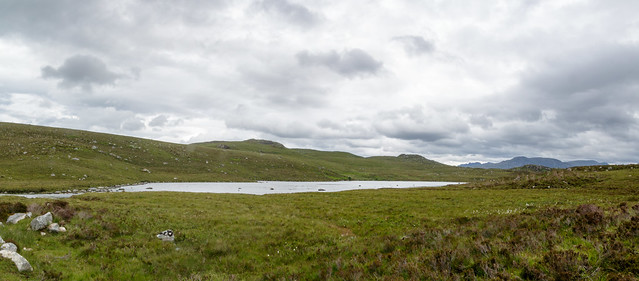
Loch na Claise Carnaich
A wee lochan near Aultbea in Wester Ross. The little hill above the loch is called Beinn Dearg Bad Chailleach while those in the distance are the more formidable hills of the Fisherfield Forest.
30-Jun-16 • Allan Ogg • flickr
loch aultbea summer landscape scotland westerross holiday walking panorama 28433460794
OS Map
This is OS mapping. In some areas, OpenStreetMap shows more footpaths
Spatial NI has online OSNI mapping. Click "Basemap Gallery" (4 squares icon at the top).
Now would be a good time for a cup of tea.
GPX Editor
Record map clicks
Reload map
Photos
Please tag your photos and upload them to the British and Irish Mountains group on Flickr
The other photos have been geo-tagged as on or around the summit. For less busy mountains, it can be a little hit and miss.
S7669 - Bad Chailleach
NG912876, LR19. HISTORY Pillar completed 15th February 1955 costing £45.19s.0d. Computed as secondary triangulation station NC20/1 within the Ullapool secondary block, and levelled to second class precision during 1955. This pillar station was last maintained by the Ordnance Survey in May 1980. SITE VISIT Overall approach from the west, Drumchork. From roadhead at NG879884, a track leads into the hills passing a covered cistern then for around 600m this track runs parallel to the perimeter fence of an oil depot. Continued on this track until around NG897874, then keeping north of Loch na Claise Carnaich, started to climb the rough boggy terrain towards the main hill. When nearer to the hill it is apparent that the rocks on the west side are sheer, so the final ascent to the summit was from the south. Open grazing hill alternatively named Beinn Dearg. The pillar is in good condition. The spider centre is open. The flush bracket faces north, compass measurement 11°. Vented through the left sight hole, the back port is starting to break open. Full 360° panoramic outlook to the surrounding hills, lochs and coastline. Photographed: 10th August 2022, GRP. ═════════════════════════ Interactive index: www.google.com/maps/d/viewer?mid=1arx2Qmo5mVeVUJA2lzVG_uzbYPW59ffh&ll=57.829830,-5.516958&z=11" rel="noreferrer nofollow Google My Maps Map: www.flickr.com/photos/13460108@N06/50432937928/in/album-72157692190778971/ Trig Pillars on OS Landranger 19 ═════════════════════════ Neighbouring Triangulation Pillars www.flickr.com/photos/13460108@N06/51364471335/in/album-72157631831281682/ S9425 - Liadh Mor : 2.19 miles to the WSW www.flickr.com/photos/13460108@N06/51364471205/in/album-72157631831281682/ S9292 - Ploc An Rudha : 4.10 miles to the SW S9427 - Beinn A` Chaisgein Beag : 4.75 miles to the SE www.flickr.com/photos/13460108@N06/52290686361/in/album-72157631801120468/ S7933 - Meall A Choire : 5.81 miles to the NNW www.flickr.com/photos/13460108@N06/51363140613/in/album-72157631874189130/ un75 - Ru Na Gavern : 6.14 miles to the W www.flickr.com/photos/13460108@N06/51361999707/in/album-72157631831281682/ S9506 - Cliff Hill : 6.15 miles to the SW www.flickr.com/photos/13460108@N06/51361999892/in/album-72157631831281682/ S9438 - Meall Tioram : 6.16 miles to the WSW S9445 - Beinn Airidh Charr : 7.23 miles to the south (X) - - - - - - - - - - - - - - - - - - - - - - - - www.flickr.com/photos/13460108@N06/52290696658/in/album-72157631347423092/ S3706 - Anteallach : 9.92 miles to the ESE. - - - - - - - - - - - - - - - - - - - - - - - - (X) = destroyed ═════════════════════════
10-Aug-22 • Graeme5015 • flickr
s7669 littlegruinard aultbea drumchork 52291180440
Loch na Claise Carnaich
A wee lochan near Aultbea in Wester Ross. The little hill above the loch is called Beinn Dearg Bad Chailleach while those in the distance are the more formidable hills of the Fisherfield Forest.
30-Jun-16 • Allan Ogg • flickr
loch aultbea summer landscape scotland westerross holiday walking panorama 28433460794
Videos
None found
Notes
- Data: Database of British and Irish Hills v18.2
- Maps: We use OS mapping for England, Scotland, Wales, and the Isle of Man. Sadly, Channel Islands, Northern (OSNI) and Southern Ireland (OSI) mapping isn't available online, so we use Openstreetmap.