Hills of Britain and Ireland
OS Map of Cruachan
Height: 537m / 1761ft • Prominence: 103m / 338ft • Summit : boulder 6m SSW of cairn • Trip reports (hill-bagging)

Loch Lomond and Arrochar
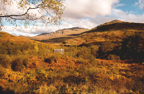
Taken from the quieter, eastern side of Loch Lomond in a colourful clearing
11-Aug-24 • Mossford Photography • flickr
scotland landscape highlands forest trees 53934277451


Sloy Power Station
A view from the hillside above Inversnaid looking across Loch Lomond to the Loch Sloy Hydo Electric Power Station. The Sloy/Awe Hydro-Electric Scheme is a hydro-electric facility situated between Loch Sloy and Inveruglas on the west bank of Loch Lomond in Scotland. The scheme was conceived by the Edinburgh architects Tarbolton & Ochterlony. Following Matthew Ochterlony's death in 1946, the scheme was progressed alone by Harold Tarbolton. Construction began in May 1945, under the auspices of the North of Scotland Hydro-Electric Board and was completed in 1949. The official opening ceremony took place on 18 October 1950 and was attended by Queen Elizabeth. The project claimed a new British small tunnelling record January 1951, after a distance of 278 ft was bored over a period of seven days. Historic Scotland has designated the modernist power-station building and the dam as listed buildings of categories A and B respectively. Twenty-one men lost their lives during the construction. The labour force also included some German prisoners-of-war. The facility is operated by Scottish and Southern Energy, and is normally in standby mode, ready to generate electricity to meet sudden peaks in demand. It can reach full capacity within 5 minutes from a standing start. Wiki Flying Steps - We Are Electric - www.youtube.com/watch?v=sNl39mjc_oU" rel="noreferrer nofollow www.youtube.com/watch?v=sNl39mjc_oU Please right click the link and open in a new tab to view and listen. Thank you ! www.flickr.com/redirect?url=www.flickriver.com/photos/61253223@N00/popular-interesting/ Rollingstone1's most interesting photos on Flickriver © All rights reserved. Use without permission is illegal. You may not download or use this image in any way without express written permission. Please contact me if you are interested in using my work.
24-Sep-22 • Rollingstone1 • flickr
lochlomond scotland powerstation hydroelectric hillside dance trees water outdoor view landscape pipes power mountains hills 52416718453

Cruinn a'Bheinn: the approach along the shore of Loch Lomond
The approach to Cruinn a'Bheinn from Inversnaid follows the West Highland Way southwards along the eastern shore of Loch Lomond for some distance before branching away steeply uphill at Cailness.
26-Jun-21 • Mumbles Head • flickr
scotland highlands mountains grahams panorama landscape loch midsummer 51334331844
Rob Roy was here
Allegedly. There's a cave nearby where the outlaw is said to have hidden. The building in view is the Inversnaid Bunkhouse, once St. Kentigerna's parish church before it was converted. The small flash of white in the trees is probably the Inversnaid Garrison, built in 1718 by the Duke of Montrose, now a Sustainable Small Holding Eco Hill Farm.
inversnaid trossachs scotland stkentigerna robroy coth5 50574012892
OS Map
This is OS mapping. In some areas, OpenStreetMap shows more footpaths
Spatial NI has online OSNI mapping. Click "Basemap Gallery" (4 squares icon at the top).
Now would be a good time for a cup of tea.
GPX Editor
Record map clicks
Reload map
Photos
Please tag your photos and upload them to the British and Irish Mountains group on Flickr
The other photos have been geo-tagged as on or around the summit. For less busy mountains, it can be a little hit and miss.
Loch Lomond and Arrochar
Taken from the quieter, eastern side of Loch Lomond in a colourful clearing
11-Aug-24 • Mossford Photography • flickr
scotland landscape highlands forest trees 53934277451
Sloy Power Station
A view from the hillside above Inversnaid looking across Loch Lomond to the Loch Sloy Hydo Electric Power Station. The Sloy/Awe Hydro-Electric Scheme is a hydro-electric facility situated between Loch Sloy and Inveruglas on the west bank of Loch Lomond in Scotland. The scheme was conceived by the Edinburgh architects Tarbolton & Ochterlony. Following Matthew Ochterlony's death in 1946, the scheme was progressed alone by Harold Tarbolton. Construction began in May 1945, under the auspices of the North of Scotland Hydro-Electric Board and was completed in 1949. The official opening ceremony took place on 18 October 1950 and was attended by Queen Elizabeth. The project claimed a new British small tunnelling record January 1951, after a distance of 278 ft was bored over a period of seven days. Historic Scotland has designated the modernist power-station building and the dam as listed buildings of categories A and B respectively. Twenty-one men lost their lives during the construction. The labour force also included some German prisoners-of-war. The facility is operated by Scottish and Southern Energy, and is normally in standby mode, ready to generate electricity to meet sudden peaks in demand. It can reach full capacity within 5 minutes from a standing start. Wiki Flying Steps - We Are Electric - www.youtube.com/watch?v=sNl39mjc_oU" rel="noreferrer nofollow www.youtube.com/watch?v=sNl39mjc_oU Please right click the link and open in a new tab to view and listen. Thank you ! www.flickr.com/redirect?url=www.flickriver.com/photos/61253223@N00/popular-interesting/ Rollingstone1's most interesting photos on Flickriver © All rights reserved. Use without permission is illegal. You may not download or use this image in any way without express written permission. Please contact me if you are interested in using my work.
24-Sep-22 • Rollingstone1 • flickr
lochlomond scotland powerstation hydroelectric hillside dance trees water outdoor view landscape pipes power mountains hills 52416718453
Cruinn a'Bheinn: the approach along the shore of Loch Lomond
The approach to Cruinn a'Bheinn from Inversnaid follows the West Highland Way southwards along the eastern shore of Loch Lomond for some distance before branching away steeply uphill at Cailness.
26-Jun-21 • Mumbles Head • flickr
scotland highlands mountains grahams panorama landscape loch midsummer 51334331844
Rob Roy was here
Allegedly. There's a cave nearby where the outlaw is said to have hidden. The building in view is the Inversnaid Bunkhouse, once St. Kentigerna's parish church before it was converted. The small flash of white in the trees is probably the Inversnaid Garrison, built in 1718 by the Duke of Montrose, now a Sustainable Small Holding Eco Hill Farm.
inversnaid trossachs scotland stkentigerna robroy coth5 50574012892

Wide horizons
I can't begin to identify the many peaks on the other side of Loch Lomond. Suffice it to say that the nearer ones are known collectively as the Arrochar Alps, comprising 4 Munros (mountains over 3000ft/914m) and 2 Corbetts (mountains between 2500ft and 3000ft).
arrocharalps lochlomond arklettrail munro corbett mountain scotland coth5 s5 50498340698

An unexpected treat
I knew from the map that falls were marked where Arklet Water flows into Loch Lomond at Inversnaid. However, these were a few minutes walk upstream & not marked individually, and thus came as a nice surprise as I followed the 'Arklet Trail' towards Inversnaid & Loch Lomond.
waterfall lochlomond scotland autumn arkletwater locharklet coth5 ngc s5 npc 50505051376


Videos
Shots taken 1 mile south from Inversnaid. In the first part you can see Inveruglas and Sloy Power Station. In the second Tarbet and ...
munrobagging #scotland #hiking Cruach Àrdrain and Beinn Tulaichean are the more central two Munros in the Crianlarich region.
002 Ben Arthur, Beinn Ime & Beinn Narnain – Full walkthrough, including climbing the Cobbler summit and timelapse. I've been ...
Beinn Tulaichean and Cruach Ardrain are two of the 7 Crianlarich Munros. They're not the largest Munros with Beinn Tulaichean ...
Notes
- Data: Database of British and Irish Hills v18.2
- Maps: We use OS mapping for England, Scotland, Wales, and the Isle of Man. Sadly, Channel Islands, Northern (OSNI) and Southern Ireland (OSI) mapping isn't available online, so we use Openstreetmap.