Hills of Britain and Ireland
OS Map of Tom na Caillich
Height: 705m / 2313ft • Prominence: 43m / 141ft • Summit : cairn on rock slab • Trip reports (hill-bagging)

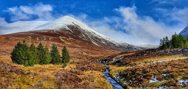
View up Allt a Bhealaich to Ben Wyvis
Ben Wyvis, Easter Ross, Highland
hillside burn stream mountain cloud moor moorland 51681786750


OS Map
This is OS mapping. In some areas, OpenStreetMap shows more footpaths
Spatial NI has online OSNI mapping. Click "Basemap Gallery" (4 squares icon at the top).
Now would be a good time for a cup of tea.
GPX Editor
Record map clicks
Reload map
Photos
Please tag your photos and upload them to the British and Irish Mountains group on Flickr
The other photos have been geo-tagged as on or around the summit. For less busy mountains, it can be a little hit and miss.
View up Allt a Bhealaich to Ben Wyvis
Ben Wyvis, Easter Ross, Highland
hillside burn stream mountain cloud moor moorland 51681786750


Winters End
12-Mar-19 • Mark.L.Sutherland • flickr
astoundingimage tartancountry garve snow top hillofterror beinnuais marilyn munro mountain benwyvis winter scottishlandscape scottishcountryside landscape highlands north uk scotland unitedkingdom trees view samsunggalaxys10plus galaxy samsung smartphone androidography cameraphone phonephotography cellphone phoneography amaturephotographer marksutherland nature mothernature weather elements hillwalking hiking outdoors beautiful stunningview wow bluesky 32539912517

Videos
None found
Notes
- Data: Database of British and Irish Hills v18.2
- Maps: We use OS mapping for England, Scotland, Wales, and the Isle of Man. Sadly, Channel Islands, Northern (OSNI) and Southern Ireland (OSI) mapping isn't available online, so we use Openstreetmap.