Hills of Britain and Ireland
OS Map of An Socach East Top
Height: 937m / 3075ft • Prominence: 39m / 128ft • Summit : shelter cairn • Trip reports (hill-bagging)
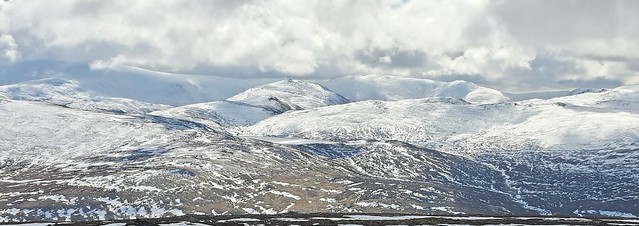
An Socach 944m (3097ft)
Munro & Corbett bagging from Braemar Easter 2023
15-Apr-23 • Phil + Heather • flickr
wml munros corbetts easter 2023 braemar scotland 52824637270

Into The Clouds
As we climb higher towards An Socach, we start reaching the cloud base, which is already touching the tops of the hills across Glen Baddock. After a few test runs and weeks of chiropractic care on my back, it's finally time to start the climbing season with a climb up An Socach. An Socach (pronounced An S-Oh-Ack) is my 17th Munro and stands at 944 meters (3097 feet), and although not the longest of climbs parts of it are very steep.
24-Apr-22 • steve_whitmarsh • flickr
aberdeenshire scotland scottishhighlands highlands cairngorms mountain hills glen ansocach landscape cloud topic 52039416706

Marker Cairn
We've reached the marker cairn, and a short rest. Ahead lies the steepest part of the climb which takes us up on to the summit plateau before we eventually reach An Socach. It will take us about 30 minutes so I'll see you up there! After a few test runs and weeks of chiropractic care on my back, it's finally time to start the climbing season with a climb up An Socach. An Socach (pronounced An S-Oh-Ack) is my 17th Munro and stands at 944 meters (3097 feet), and although not the longest of climbs parts of it are very steep.
24-Apr-22 • steve_whitmarsh • flickr
aberdeenshire scotland scottishhighlands highlands cairngorms mountain hills glen ansocach landscape snow cairn rock rocks topic rockpaper 52037593314

Hitting Cloud Base
As we start to reach the summit plateau of An Socach, we also climb into the cloud base as we look back the way we've come. It was swirling around us and formed a wall of white, not like fog at all really. Eating the sandwiches in the lee of a shelter cairn, we had wisps of cloud blowing just beyond our feet, a quite magical experience. After a few test runs and weeks of chiropractic care on my back, it's finally time to start the climbing season with a climb up An Socach. An Socach (pronounced An S-Oh-Ack) is my 17th Munro and stands at 944 meters (3097 feet), and although not the longest of climbs parts of it are very steep.
24-Apr-22 • steve_whitmarsh • flickr
aberdeenshire scotland scottishhighlands highlands cairngorms mountain hills glen ansocach landscape snow cloud topic rockpaper 52044672825

Scottish Glens
After sandwiches and a quick rest, we continue making our way across the summit plateau to reach the true summit of An Socach. As we do so the clouds quickly lifted and the sun came out, revealing this amazing view down into Glen Ey. To the left of image, the summit Carn Bhac can be seen, while in the distance the high Cairngorms are shrouded in cloud. After a few test runs and weeks of chiropractic care on my back, it's finally time to start the climbing season with a climb up An Socach. An Socach (pronounced An S-Oh-Ack) is my 17th Munro and stands at 944 meters (3097 feet), and although not the longest of climbs parts of it are very steep.
24-Apr-22 • steve_whitmarsh • flickr
aberdeenshire scotland scottishhighlands highlands cairngorms mountain hills glen ansocach landscape rock rocks gleney topic rockpaper 52047356225

Hidden Lochs
About halfway along the ridge taking us to An Socach, we have a dramatic view across the mountains around Glenshee. Nestled among them lies the remote Loch Nan Eun, with the still snow covered Glas Tulaichean beyond. After a few test runs and weeks of chiropractic care on my back, it's finally time to start the climbing season with a climb up An Socach. An Socach (pronounced An S-Oh-Ack) is my 17th Munro and stands at 944 meters (3097 feet), and although not the longest of climbs parts of it are very steep.
24-Apr-22 • steve_whitmarsh • flickr
aberdeenshire scotland scottishhighlands highlands cairngorms mountain hills glen ansocach landscape topic 52049424499
OS Map
This is OS mapping. In some areas, OpenStreetMap shows more footpaths
Spatial NI has online OSNI mapping. Click "Basemap Gallery" (4 squares icon at the top).
Now would be a good time for a cup of tea.
GPX Editor
Record map clicks
Reload map
Photos
Please tag your photos and upload them to the British and Irish Mountains group on Flickr
The other photos have been geo-tagged as on or around the summit. For less busy mountains, it can be a little hit and miss.
An Socach 944m (3097ft)
Munro & Corbett bagging from Braemar Easter 2023
15-Apr-23 • Phil + Heather • flickr
wml munros corbetts easter 2023 braemar scotland 52824637270
Into The Clouds
As we climb higher towards An Socach, we start reaching the cloud base, which is already touching the tops of the hills across Glen Baddock. After a few test runs and weeks of chiropractic care on my back, it's finally time to start the climbing season with a climb up An Socach. An Socach (pronounced An S-Oh-Ack) is my 17th Munro and stands at 944 meters (3097 feet), and although not the longest of climbs parts of it are very steep.
24-Apr-22 • steve_whitmarsh • flickr
aberdeenshire scotland scottishhighlands highlands cairngorms mountain hills glen ansocach landscape cloud topic 52039416706
Marker Cairn
We've reached the marker cairn, and a short rest. Ahead lies the steepest part of the climb which takes us up on to the summit plateau before we eventually reach An Socach. It will take us about 30 minutes so I'll see you up there! After a few test runs and weeks of chiropractic care on my back, it's finally time to start the climbing season with a climb up An Socach. An Socach (pronounced An S-Oh-Ack) is my 17th Munro and stands at 944 meters (3097 feet), and although not the longest of climbs parts of it are very steep.
24-Apr-22 • steve_whitmarsh • flickr
aberdeenshire scotland scottishhighlands highlands cairngorms mountain hills glen ansocach landscape snow cairn rock rocks topic rockpaper 52037593314
Hitting Cloud Base
As we start to reach the summit plateau of An Socach, we also climb into the cloud base as we look back the way we've come. It was swirling around us and formed a wall of white, not like fog at all really. Eating the sandwiches in the lee of a shelter cairn, we had wisps of cloud blowing just beyond our feet, a quite magical experience. After a few test runs and weeks of chiropractic care on my back, it's finally time to start the climbing season with a climb up An Socach. An Socach (pronounced An S-Oh-Ack) is my 17th Munro and stands at 944 meters (3097 feet), and although not the longest of climbs parts of it are very steep.
24-Apr-22 • steve_whitmarsh • flickr
aberdeenshire scotland scottishhighlands highlands cairngorms mountain hills glen ansocach landscape snow cloud topic rockpaper 52044672825
Scottish Glens
After sandwiches and a quick rest, we continue making our way across the summit plateau to reach the true summit of An Socach. As we do so the clouds quickly lifted and the sun came out, revealing this amazing view down into Glen Ey. To the left of image, the summit Carn Bhac can be seen, while in the distance the high Cairngorms are shrouded in cloud. After a few test runs and weeks of chiropractic care on my back, it's finally time to start the climbing season with a climb up An Socach. An Socach (pronounced An S-Oh-Ack) is my 17th Munro and stands at 944 meters (3097 feet), and although not the longest of climbs parts of it are very steep.
24-Apr-22 • steve_whitmarsh • flickr
aberdeenshire scotland scottishhighlands highlands cairngorms mountain hills glen ansocach landscape rock rocks gleney topic rockpaper 52047356225
Hidden Lochs
About halfway along the ridge taking us to An Socach, we have a dramatic view across the mountains around Glenshee. Nestled among them lies the remote Loch Nan Eun, with the still snow covered Glas Tulaichean beyond. After a few test runs and weeks of chiropractic care on my back, it's finally time to start the climbing season with a climb up An Socach. An Socach (pronounced An S-Oh-Ack) is my 17th Munro and stands at 944 meters (3097 feet), and although not the longest of climbs parts of it are very steep.
24-Apr-22 • steve_whitmarsh • flickr
aberdeenshire scotland scottishhighlands highlands cairngorms mountain hills glen ansocach landscape topic 52049424499

Glenshee Panoramic
This scene was shrouded in cloud on our way up An Scoach, but crossing back over the summit ridge we now have a fine view across to Glenshee, with Carn Aosda on the left and The Cairnwell on the right, with Loch Vrotachan between them both. After a few test runs and weeks of chiropractic care on my back, it's finally time to start the climbing season with a climb up An Socach. An Socach (pronounced An S-Oh-Ack) is my 17th Munro and stands at 944 meters (3097 feet), and although not the longest of climbs parts of it are very steep.
24-Apr-22 • steve_whitmarsh • flickr
aberdeenshire scotland scottishhighlands highlands cairngorms mountain hills glen ansocach landscape panorama cloud 52062261162

Glen Baddock
On the way up this scene was shrouded in cloud as it swirled around us. Now we have fine view of Glen Baddock into which we are now descending to pick up the bikes once more. After a few test runs and weeks of chiropractic care on my back, it's finally time to start the climbing season with a climb up An Socach. An Socach (pronounced An S-Oh-Ack) is my 17th Munro and stands at 944 meters (3097 feet), and although not the longest of climbs parts of it are very steep.
24-Apr-22 • steve_whitmarsh • flickr
aberdeenshire scotland scottishhighlands highlands cairngorms mountain hills glen ansocach landscape snow rock rocks topic rockpaper 52065477621

Marker Cairn
The same marker cairn we passed on the way up An Socach now offers a great view of Glen Baddock as we descend back down in glorious sunshine. After a few test runs and weeks of chiropractic care on my back, it's finally time to start the climbing season with a climb up An Socach. An Socach (pronounced An S-Oh-Ack) is my 17th Munro and stands at 944 meters (3097 feet), and although not the longest of climbs parts of it are very steep.
24-Apr-22 • steve_whitmarsh • flickr
aberdeenshire scotland scottishhighlands highlands cairngorms mountain hills glen ansocach landscape cairn rock rocks topic rockpaper 52068249110

Videos
Hiking Glenshee 9 Munros Scotland in One Day! It took around 16 hours to complete the hiking circuit. Munros: ✓Glas Maol ...
Notes
- Data: Database of British and Irish Hills v18.2
- Maps: We use OS mapping for England, Scotland, Wales, and the Isle of Man. Sadly, Channel Islands, Northern (OSNI) and Southern Ireland (OSI) mapping isn't available online, so we use Openstreetmap.