Hills of Britain and Ireland
OS Map of The Bruach
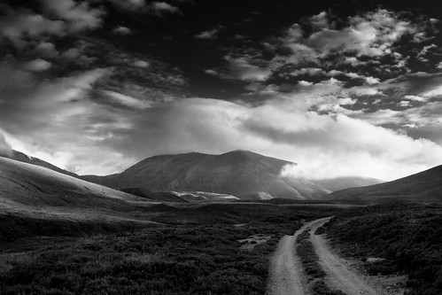
Stob an t-Sluichd
It's turning 8pm. An hour ago I took a shot - A Road Less Travelled - at the crest of the trail, before it descended into this wider section of the glen, but I couldn't tear myself away from the transient light tracing across the mountains, so most of the last hour was spent at that vantage point. Now the clouds are starting to burn with the last rays of sunlight. I thought it was around 6km to go at the last stop, but taking in to account the winding path, it's probably still a good 6km to the place I've never been to or seen before, but where I'll be calling base camp for the night: Faindouran Lodge. The River Avon runs alongside me, and Stob an t-Sluichd looks mighty, dominating the view as I continue deeper into the glen.
20-Aug-16 • Kieran Campbell • flickr
avon cairngorms highlands moray scotland stobantsluichd alba glen braemar unitedkingdom 29298470854

Ben Avon Case Closed
August 2nd 2009 I cycled from Tomintoul a 24 mile cycle round trip plus a 10 mile walk up Beinn a' Bhuird and then Ben Avon . On the way home feeling very pleased with myself I began to get strange sensations like electric shocks down one side of my body. This led to three years of illness culminating in serious neurosurgery last week which would appear to have resolved most of the problem possibly all of the problem. I get emotional, very emotional when I realise this in a very positive way . Reviewing my pictures I found this old shot of the mountain range which I cycled and walked that day and it brings back memories of the freedom that the hills gave me , the pain and frustration of the; last few years and the support I have had through this weird painful illness. It will be finally over when I return to work but yes I feel it is case closed:)
27-Nov-11 • John Ferguson Moray • flickr
sescape 9587529008
OS Map
This is OS mapping. In some areas, OpenStreetMap shows more footpaths
Spatial NI has online OSNI mapping. Click "Basemap Gallery" (4 squares icon at the top).
Now would be a good time for a cup of tea.
GPX Editor
Record map clicks
Reload map
Photos
Please tag your photos and upload them to the British and Irish Mountains group on Flickr
The other photos have been geo-tagged as on or around the summit. For less busy mountains, it can be a little hit and miss.
Stob an t-Sluichd
It's turning 8pm. An hour ago I took a shot - A Road Less Travelled - at the crest of the trail, before it descended into this wider section of the glen, but I couldn't tear myself away from the transient light tracing across the mountains, so most of the last hour was spent at that vantage point. Now the clouds are starting to burn with the last rays of sunlight. I thought it was around 6km to go at the last stop, but taking in to account the winding path, it's probably still a good 6km to the place I've never been to or seen before, but where I'll be calling base camp for the night: Faindouran Lodge. The River Avon runs alongside me, and Stob an t-Sluichd looks mighty, dominating the view as I continue deeper into the glen.
20-Aug-16 • Kieran Campbell • flickr
avon cairngorms highlands moray scotland stobantsluichd alba glen braemar unitedkingdom 29298470854
Ben Avon Case Closed
August 2nd 2009 I cycled from Tomintoul a 24 mile cycle round trip plus a 10 mile walk up Beinn a' Bhuird and then Ben Avon . On the way home feeling very pleased with myself I began to get strange sensations like electric shocks down one side of my body. This led to three years of illness culminating in serious neurosurgery last week which would appear to have resolved most of the problem possibly all of the problem. I get emotional, very emotional when I realise this in a very positive way . Reviewing my pictures I found this old shot of the mountain range which I cycled and walked that day and it brings back memories of the freedom that the hills gave me , the pain and frustration of the; last few years and the support I have had through this weird painful illness. It will be finally over when I return to work but yes I feel it is case closed:)
27-Nov-11 • John Ferguson Moray • flickr
sescape 9587529008
Videos
Instagram https://www.instagram.com/scottishmunrojourney/ ➤ TikTok https://www.tiktok.com/@scottishmountains ➤ Email ...
Video of full length of Aviemore funicular railway, February 2018. Was a bit jammed in the carriage so only able to see the view ...
Notes
- Data: Database of British and Irish Hills v18.2
- Maps: We use OS mapping for England, Scotland, Wales, and the Isle of Man. Sadly, Channel Islands, Northern (OSNI) and Southern Ireland (OSI) mapping isn't available online, so we use Openstreetmap.