Hills of Britain and Ireland
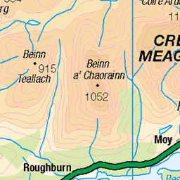
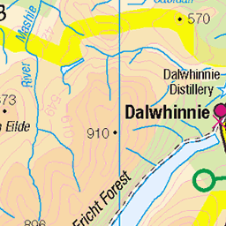
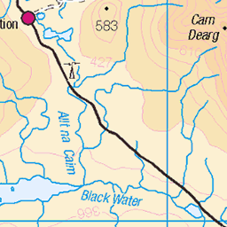
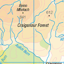
OS Map of Ben Alder
Height: 1148m / 3766ft • Prominence: 783m / 2569ft • Summit : trig point • Trip reports (hill-bagging)

photo
Loch's Pattach and Ericht from somewhere near the top of Ben Alder's Long Leachas ridge. It's not far from this point that the ridge tops out on the Ben Alder plateau, but this view back is the star of the show.
27-Sep-24 • OutdoorMonkey • flickr
benalder longleachas remote wild wilderness countryside outside outdoor nature natural scenic scenery mountain mountainside ridge scotland scottish highlands lochericht 54093270316

Long Leachas panorama
Near the top of Ben Alder's Long Leachas ridge, looking towards a sunlit Lancet Edge (the ridge up Sgor Iutharn), left, and Loch Ericht in the distance on the right.
27-Sep-24 • OutdoorMonkey • flickr
benalder longleachas remote wild wilderness countryside outside outdoor nature natural scenic scenery mountain mountainside ridge scotland scottish highlands lancetedge sgoriutharn lochericht panorama 54093270706

photo
A dusting of snow on Ben Alder's plateau near the top of the Long Leachas ridge. The dark mountain across the loch on the left is Beinn Bheoil.
27-Sep-24 • OutdoorMonkey • flickr
54093804660

Ben Alder plateau
Near the summit of Ben Alder as a snow shower breezes past. Lochan a' Garbh Coire is visible under the dark cloud in the middle distance on the right. Ben Alder is 1148m / 3766ft high. There was snow blowing on a 30mph northerly wind on this day, and (despite the magnificent views) it wasn't a place to hang about.
27-Sep-24 • OutdoorMonkey • flickr
54093599223

photo
Beinn Bheoil from the top of the Ben Alder cliffs above Garbh Choire.
27-Sep-24 • OutdoorMonkey • flickr
54093348211

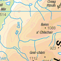
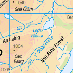
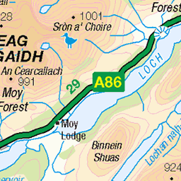
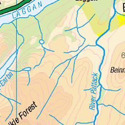
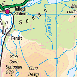
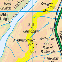
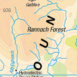
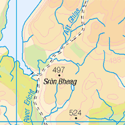
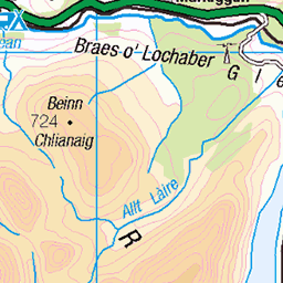
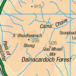
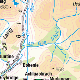
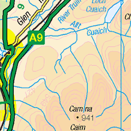
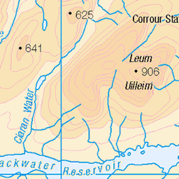
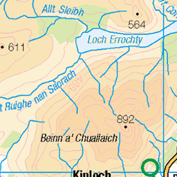
OS Map
This is OS mapping. In some areas, OpenStreetMap shows more footpaths
Spatial NI has online OSNI mapping. Click "Basemap Gallery" (4 squares icon at the top).
Now would be a good time for a cup of tea.
GPX Editor
Record map clicks
Reload map
Photos
Please tag your photos and upload them to the British and Irish Mountains group on Flickr
The other photos have been geo-tagged as on or around the summit. For less busy mountains, it can be a little hit and miss.
photo
Loch's Pattach and Ericht from somewhere near the top of Ben Alder's Long Leachas ridge. It's not far from this point that the ridge tops out on the Ben Alder plateau, but this view back is the star of the show.
27-Sep-24 • OutdoorMonkey • flickr
benalder longleachas remote wild wilderness countryside outside outdoor nature natural scenic scenery mountain mountainside ridge scotland scottish highlands lochericht 54093270316
Long Leachas panorama
Near the top of Ben Alder's Long Leachas ridge, looking towards a sunlit Lancet Edge (the ridge up Sgor Iutharn), left, and Loch Ericht in the distance on the right.
27-Sep-24 • OutdoorMonkey • flickr
benalder longleachas remote wild wilderness countryside outside outdoor nature natural scenic scenery mountain mountainside ridge scotland scottish highlands lancetedge sgoriutharn lochericht panorama 54093270706
photo
A dusting of snow on Ben Alder's plateau near the top of the Long Leachas ridge. The dark mountain across the loch on the left is Beinn Bheoil.
27-Sep-24 • OutdoorMonkey • flickr
54093804660
Ben Alder plateau
Near the summit of Ben Alder as a snow shower breezes past. Lochan a' Garbh Coire is visible under the dark cloud in the middle distance on the right. Ben Alder is 1148m / 3766ft high. There was snow blowing on a 30mph northerly wind on this day, and (despite the magnificent views) it wasn't a place to hang about.
27-Sep-24 • OutdoorMonkey • flickr
54093599223
photo
Beinn Bheoil from the top of the Ben Alder cliffs above Garbh Choire.
27-Sep-24 • OutdoorMonkey • flickr
54093348211


IMG_2381
Griff in classic pose - horizontal lunch - recuperating out of the wind
05-Jun-22 • Powsers Mountaineering Club • flickr
52460049582

IMG_2383
Four of the team re-charging batteries before the final climb on to Ben Alder
05-Jun-22 • Powsers Mountaineering Club • flickr
52460832319

345 Ben Alder
Very sunny with Big John, Colin, Bill, Pat and June. Backpacking trip. Name:Ben Alder Hill number:345 Height:1148m / 3766ft RHB Section:04B: Loch Treig to Loch Ericht County/UA:Highland (UA) Catchment:Catchment Boundaries, Lochy, Tay Watershed:Firth of Tay, Mull of Kintyre to Rattray Head, Ardnamurchan Point to Lowestoft, Cardiff to Cape Wrath, Dover to Cape Wrath, Lowestoft to Duncansby Head, Greater Loch Linnhe, Land's End to John o' Groats, The Lizard to Dunnet Head Class:Marilyn, Hump, Simm, Munro, Murdo, Yeaman, Trail 100 Grid ref:NN 49619 71846 Summit feature:trig point Drop:783m Col:365m NN262668 Observations:cairn 15m E at NN 49633 71847 may be as high
14-Dec-20 • Dugswell2 • flickr
benalderbackpackingtrip 30051999 benalder p783 tump marilyn hump simm munro murdo yeaman trail100 50718884638
Videos
In today's video I will be climbing the 6 Remote Munros of Ben Alder, this includes a 19 mile cycle & 17 Mile Walk on some pretty ...
A 10 mile walk from Dalwhinnie into the Ben Alder Estate to climb the 2 remote Munros Ben Alder and Beinn Bheòil. I found a ...
Join me and my four legged friend Luna for a fine hike and the dog's first bothy night away to Ben Alder Cottage, an alledgedly ...
The Adventure Club's expedition and summit camp on Ben Alder. Measuring 1148 metres (3766 ft) this Scottish Munro is the ...
mtbtrail #emtb #mtblife Ben Alder, Cairngorms. Another epic day on the emtb Not a big mountain day today but certainly a ...
Notes
- Data: Database of British and Irish Hills v18.2
- Maps: We use OS mapping for England, Scotland, Wales, and the Isle of Man. Sadly, Channel Islands, Northern (OSNI) and Southern Ireland (OSI) mapping isn't available online, so we use Openstreetmap.