Hills of Britain and Ireland
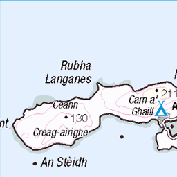
OS Map of Sgurr nan Gillean
Height: 764m / 2507ft • Prominence: 79m / 259ft • Summit : rock in grass 10m ESE of cairn • Trip reports (hill-bagging)

Dawn on the Rùm Coast
The Sun starting to rise at the coast of Rùm
22-Jul-23 • Will Dale - Out and About • flickr
dawn island islands landscape longexposure lowkey photography places rhum rum scotland scottishhighlands scottishislands sea seascape sky smallisles sunrise uk unitedkingdom isleofrum 54059795252

Waterfall flowing into the sea
Waterfall on the island of Rùm flowing into the sea with mountains behind
21-Jul-23 • Will Dale - Out and About • flickr
cloud clouds island islands landscape longexposure nature photography places rhum rum scotland scottishhighlands scottishislands sky smallisles stream uk unitedkingdom waterfall isleofrum 54061123499

The traverse of the Rum Cuillin: Hallival and Askival from between Ainshval and Sgurr nan Gillean
The summit cairn of Ainshval left of picture
21-Jun-18 • Mumbles Head • flickr
42355986795


The traverse of the Rum Cuillin: finishing point, Dibidil bothy
The Isle of Eigg across the water from here
21-Jun-18 • Mumbles Head • flickr
43210998402

The traverse of the Rum Cuillin: circuiting the island to the starting point
Dibidil is at the other end of the island almost from Kinloch and it is several hours walk back along the coast from here. Fortunately, it was the longest day, I got back to the starting point at 11pm, after a walk of 14.5 hours (I am sure it can be done a lot quicker, especially if you don't take a camera). The peak to the left is Sgurr nan Gillean. The picture shows how steep the eastern face of the mountain is, necessitating a more or less southerly descent from the summit to avoid the crags.
21-Jun-18 • Mumbles Head • flickr
43259810311
OS Map
This is OS mapping. In some areas, OpenStreetMap shows more footpaths
Spatial NI has online OSNI mapping. Click "Basemap Gallery" (4 squares icon at the top).
Now would be a good time for a cup of tea.

GPX Editor
Record map clicks
Reload map
Photos
Please tag your photos and upload them to the British and Irish Mountains group on Flickr
The other photos have been geo-tagged as on or around the summit. For less busy mountains, it can be a little hit and miss.
Dawn on the Rùm Coast
The Sun starting to rise at the coast of Rùm
22-Jul-23 • Will Dale - Out and About • flickr
dawn island islands landscape longexposure lowkey photography places rhum rum scotland scottishhighlands scottishislands sea seascape sky smallisles sunrise uk unitedkingdom isleofrum 54059795252
Waterfall flowing into the sea
Waterfall on the island of Rùm flowing into the sea with mountains behind
21-Jul-23 • Will Dale - Out and About • flickr
cloud clouds island islands landscape longexposure nature photography places rhum rum scotland scottishhighlands scottishislands sky smallisles stream uk unitedkingdom waterfall isleofrum 54061123499
The traverse of the Rum Cuillin: Hallival and Askival from between Ainshval and Sgurr nan Gillean
The summit cairn of Ainshval left of picture
21-Jun-18 • Mumbles Head • flickr
42355986795
The traverse of the Rum Cuillin: finishing point, Dibidil bothy
The Isle of Eigg across the water from here
21-Jun-18 • Mumbles Head • flickr
43210998402
The traverse of the Rum Cuillin: circuiting the island to the starting point
Dibidil is at the other end of the island almost from Kinloch and it is several hours walk back along the coast from here. Fortunately, it was the longest day, I got back to the starting point at 11pm, after a walk of 14.5 hours (I am sure it can be done a lot quicker, especially if you don't take a camera). The peak to the left is Sgurr nan Gillean. The picture shows how steep the eastern face of the mountain is, necessitating a more or less southerly descent from the summit to avoid the crags.
21-Jun-18 • Mumbles Head • flickr
43259810311

Dibidil bothy
Dibidil bothy I was stuck here for 3 nights in bad weather. Not bad place to get stuck. The river crossing was hard as it was high in the storm when i arrived and the route to in was tricky in the storm to. Isle of Rum. Scotland UK www.experimentalist.co.uk" rel="nofollow www.experimentalist.co.uk
uk travel holiday walking island islands scotland highlands walks britain hiking walk hike backpacking rum isle isles hikes bothy isleofrum dibidil bothies dibidilbothy 10491137844


KR72-06-107a
Dibidil bothy, Rum, 1972
21-May-72 • Rudsambass • flickr
rum rhum bothy dibidil 21872815138
Videos
Fourth and last day on the Small Isles - leaving Canna on Saturday morning to spend half a day on the Isle of Eigg. We only had ...
Notes
- Data: Database of British and Irish Hills v18.2
- Maps: We use OS mapping for England, Scotland, Wales, and the Isle of Man. Sadly, Channel Islands, Northern (OSNI) and Southern Ireland (OSI) mapping isn't available online, so we use Openstreetmap.