Hills of Britain and Ireland
OS Map of Meall Tionail

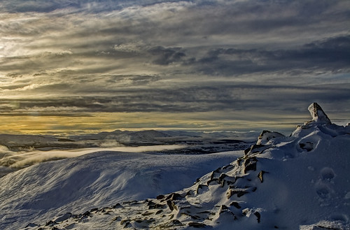
Final Stretch
The last section of the ascent of Carn a' Chlamain backed by Glen Tilt and Beinn a' Ghlo.
23-Sep-18 • Russell-Davies • flickr
cairngorms canon 6dmkii blairatholl glentilt uk scotland highlands carnachlamain hiking summit mountain wilderness hills 44287359744

Tarf Water Rainbow
A brief rainbow while looking toward the wilderness around Tarf Water and beyond from the summit of Carn a' Chlamain.
23-Sep-18 • Russell-Davies • flickr
carnachlamain blairatholl glentilt rainbow munro clouds shower autumn uk scotland highlands cairngorms canon 6dmkii hiking 44298484104

Carn an Righ & Beinn Lutharn Mhor
The Munro's of Carn an Righ and Beinn lutharn Mhor taken from Carn a' Chlamain across Glen Tilt and southern Cairngorms desolation.
23-Sep-18 • Russell-Davies • flickr
cairngorms uk scotland highlands carnachlamain hills autumn canon 6dmkii hiking wilderness remote perthshire munro plateau 44994209581

Tarf Hotel Bothy
14-Aug-18 • Paweł Błaszak • flickr
landscape nature grampians uk mountains scotland 47447091052
Carn a Chlamain Dec 2011 #15
Carn a Chlamain summit
mountain landscape scotland wintersunset munro 8705546044

Carn a Chlamain Dec 2011 #16
Beinn a Ghlo from Carn a Chlamain summit
winter mountain landscape scotland munro 8704527775
OS Map
This is OS mapping. In some areas, OpenStreetMap shows more footpaths
Spatial NI has online OSNI mapping. Click "Basemap Gallery" (4 squares icon at the top).
Now would be a good time for a cup of tea.
GPX Editor
Record map clicks
Reload map
Photos
Please tag your photos and upload them to the British and Irish Mountains group on Flickr
The other photos have been geo-tagged as on or around the summit. For less busy mountains, it can be a little hit and miss.
Final Stretch
The last section of the ascent of Carn a' Chlamain backed by Glen Tilt and Beinn a' Ghlo.
23-Sep-18 • Russell-Davies • flickr
cairngorms canon 6dmkii blairatholl glentilt uk scotland highlands carnachlamain hiking summit mountain wilderness hills 44287359744
Tarf Water Rainbow
A brief rainbow while looking toward the wilderness around Tarf Water and beyond from the summit of Carn a' Chlamain.
23-Sep-18 • Russell-Davies • flickr
carnachlamain blairatholl glentilt rainbow munro clouds shower autumn uk scotland highlands cairngorms canon 6dmkii hiking 44298484104
Carn an Righ & Beinn Lutharn Mhor
The Munro's of Carn an Righ and Beinn lutharn Mhor taken from Carn a' Chlamain across Glen Tilt and southern Cairngorms desolation.
23-Sep-18 • Russell-Davies • flickr
cairngorms uk scotland highlands carnachlamain hills autumn canon 6dmkii hiking wilderness remote perthshire munro plateau 44994209581
Tarf Hotel Bothy
14-Aug-18 • Paweł Błaszak • flickr
landscape nature grampians uk mountains scotland 47447091052
Carn a Chlamain Dec 2011 #15
Carn a Chlamain summit
mountain landscape scotland wintersunset munro 8705546044
Carn a Chlamain Dec 2011 #16
Beinn a Ghlo from Carn a Chlamain summit
winter mountain landscape scotland munro 8704527775

Carn a Chlamain Dec 2011 #14
Carn a Chlamain summit
winter mountain landscape scotland munro 8546390456

escape from tarf bothy
craig & i trekked into tarf bothy in the middle of the grampian mountains in march. there was full snow cover all the way to the main road at blair atholl & crampons were nearly donned to negotiate the treacherous ice in the car-park. with a fear of getting cold we were each carrying a 10kg bag of coal and the hike into the bothy was a 9hr epic. we saw no one. our aim had been a bold attempt on an sgarsoch in winter from the south- one of the remotest munros and sited in real tiger country. we never made it. craig had buggered his ankle on the long march in. as i stared at the glittering, snowy slopes of the munro twinkling in the moonlight , tantalisingly close, from the door of the bothy that night i dreamt of a solo moonlit ascent across untrodden snow fields. craig however luckily talked sense into me- no margins for error on that planned trip if anything should go wrong(getting lost/injured)- we were literally miles & miles & hours & hours from any possibility of alerting rescue so i would have been over 24hrs from help and unlikely to survive in those conditions. just as well he talked me out of it too! we woke the next morning to find a front had moved in and the clear, cold skies of the night before had given way to cloud that was down at the level of the bothy (400m/1300') and we turned tail and retreated to civilisation over the munro of carn na chlamein. this photo was taken on the climb up to the summit of that munro from the northern side where tarf bothy sits in empty country. it was white-out conditions & i was out front navigating by a compass with craig following behind over my shoulder checking my bearing with his compass. By
06-Mar-02 • johnalbiston • flickr
3100836771
Videos
None found
Notes
- Data: Database of British and Irish Hills v18.2
- Maps: We use OS mapping for England, Scotland, Wales, and the Isle of Man. Sadly, Channel Islands, Northern (OSNI) and Southern Ireland (OSI) mapping isn't available online, so we use Openstreetmap.