Hills of Britain and Ireland
OS Map of Creag an Dubh-chadha

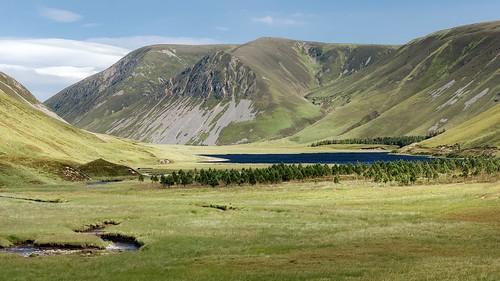
Loch Bhrodainn Landscape
A lovely day for cycling in the Highlands.
07-Sep-23 • eric robb niven • flickr
ericrobbniven scotland dundee dalwhinnie kingussie dalnacardoch cycling mountain biking gaick hills 53172974935
In the middle of Gaick Forest
25-Jul-19 • Paweł Błaszak • flickr
uk grampians landscape mountains nature scotland 49573922211


P20 Looking S to pass on left
As the track heads north the obvious glacial trench takes the route towards Gaick.
06-Aug-09 • Grahamtravels • flickr
6298775541

P21 Ford S of Loch Bhrodainn
South of Loch Bhrodainn a burn has to be forded. Judging by the amount of flood debris it might be difficult in wet weather in a remote area.
06-Aug-09 • Grahamtravels • flickr
6298777279
OS Map
This is OS mapping. In some areas, OpenStreetMap shows more footpaths
Spatial NI has online OSNI mapping. Click "Basemap Gallery" (4 squares icon at the top).
Now would be a good time for a cup of tea.
GPX Editor
Record map clicks
Reload map
Photos
Please tag your photos and upload them to the British and Irish Mountains group on Flickr
The other photos have been geo-tagged as on or around the summit. For less busy mountains, it can be a little hit and miss.
Loch Bhrodainn Landscape
A lovely day for cycling in the Highlands.
07-Sep-23 • eric robb niven • flickr
ericrobbniven scotland dundee dalwhinnie kingussie dalnacardoch cycling mountain biking gaick hills 53172974935
In the middle of Gaick Forest
25-Jul-19 • Paweł Błaszak • flickr
uk grampians landscape mountains nature scotland 49573922211
P20 Looking S to pass on left
As the track heads north the obvious glacial trench takes the route towards Gaick.
06-Aug-09 • Grahamtravels • flickr
6298775541
P21 Ford S of Loch Bhrodainn
South of Loch Bhrodainn a burn has to be forded. Judging by the amount of flood debris it might be difficult in wet weather in a remote area.
06-Aug-09 • Grahamtravels • flickr
6298777279

P22 Looking S from ford
From the ford south of Loch Bhrodainn the glacial nature of the Gaick shows well.
06-Aug-09 • Grahamtravels • flickr
6298778883

P23 Loch Bhrodainn
The Gaick area shows much evidence of the effects of ice ages on the landscape.
06-Aug-09 • Grahamtravels • flickr
4727359237

Videos
None found
Notes
- Data: Database of British and Irish Hills v18.2
- Maps: We use OS mapping for England, Scotland, Wales, and the Isle of Man. Sadly, Channel Islands, Northern (OSNI) and Southern Ireland (OSI) mapping isn't available online, so we use Openstreetmap.