Hills of Britain and Ireland
OS Map of Stob Coire Easain


OS Map
This is OS mapping. In some areas, OpenStreetMap shows more footpaths
Spatial NI has online OSNI mapping. Click "Basemap Gallery" (4 squares icon at the top).
Now would be a good time for a cup of tea.
GPX Editor
Record map clicks
Reload map
Photos
Please tag your photos and upload them to the British and Irish Mountains group on Flickr
The other photos have been geo-tagged as on or around the summit. For less busy mountains, it can be a little hit and miss.

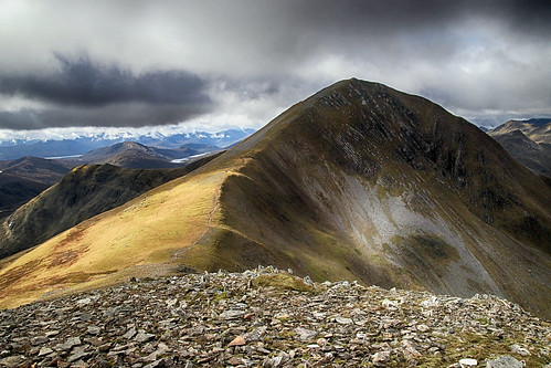
Stob Coire Easain
The shapely outline of Stob Coire Easain seen while re-ascending Stob a'Choire Mheadhoin.
31-Jul-20 • Russell-Davies • flickr
stobcoireeasain munro stobachoiremheadhoin hiking ridge mountain landscape canon 6dmkii uk scotland highlands summit 50361089781
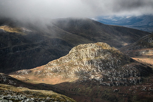
Sgurr Innse
A view of corbett mountain Sgurr Innse from nearby Stob a' Choire Mheadhoin (one of the Easains). The mountains under cloud beyond it are the eastern 'Grey Corries'.
28-Sep-19 • OutdoorMonkey • flickr
stobachoiremheadhoin sgurrinnse corbett mountain peak summit landscape sunshine sunlight rocky rugged outside outdoor rural nature natural scenic scenery lochaber scotland highlands greycorries 48847530663
Stob Coire Easain
The stunning view of this great mountain from it's twin/neighbour Stob a' Choire Mheadhoin.
28-Sep-19 • OutdoorMonkey • flickr
stobachoiremheadhoin stobcoireeasain easains lochaber scotland highlands mountain peak summit ridge munro outside outdoor rural nature natural scenic scenery landscape 48847834498

Easain panorama
Looking west at the Grey Corries from the Easains.
28-Sep-19 • OutdoorMonkey • flickr
mountain mountainside panorama panoramic easain easains peak summit munro greycorries rock boulder lochaber scotland highlands outside outdoor rural nature natural scenic scenery innse 48848440481
Videos
In today's video I will be Munro Bagging the Two Munros from Fersit in Spean Bridge, near Fort William. The first is Stob Coire ...
Stob Coire Easain and Stob a'Choire Mheadhoin, from Fersit, Loch Treig. Solo Hike #hiking #scotland #munro.
A solo hike from Fersit up to the 2 Munros Stob Coire Sgriodain and Chno Dearg. This hike is pretty much pathless and is rough ...
2 Munros East side of loch Trieg in Winter conditions.
1115m, Munro.
Notes
- Data: Database of British and Irish Hills v18.2
- Maps: We use OS mapping for England, Scotland, Wales, and the Isle of Man. Sadly, Channel Islands, Northern (OSNI) and Southern Ireland (OSI) mapping isn't available online, so we use Openstreetmap.