Hills of Britain and Ireland
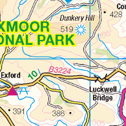
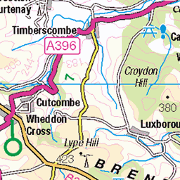
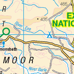
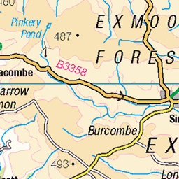
OS Map of Selworthy Beacon
Height: 309m / 1012ft • Prominence: 192m / 630ft • Summit : ground 2m NW of trig point • Trip reports (hill-bagging)

On the woodland trail
From last weekend and a circular hike along the north Exmoor coast. This was the woodland path leading to the picturesque village of Selworthy.
22-Feb-25 • Christian Hacker • flickr
woodlandtrail forest woodland woods trees backlight hiking trail path oak exmoor somerset uk canon eos50d tamron 1750mm nature selworthycombe mossyroots roots moss 54353688916

Church of All Saints
The church sits on a hillside above Selworthy, near the northern coast in Somerset. The church is from the 15th century, with a 14th century tower and is whitewashed as opposed to many other churches in England. I wish I had a wide-angle lens as I had to merge two individual photos to get the church into the frame from that angle.
22-Feb-25 • Christian Hacker • flickr
selworthy somerset church churchofallsaints whitewashed historicbuilding gradeilisted england uk canon eos50d churchcemetery vertorama architecture historic 54352098900

Selworthy
Last weekend, we spent a day at the northern tip of Exmoor National Park. One of the places we visited was the lovely village of Selworthy. Dotted with thatched roof hobbit houses, this made for a fabulous location to have cream tea in the sunshine!
22-Feb-25 • Christian Hacker • flickr
selworthy thatchedroof nationaltrust englishvillage village house scenic periwinkletearoom picturesque somerset uk canon eos50d tamron 1750mm 54347573426


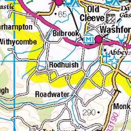
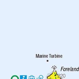
OS Map
This is OS mapping. In some areas, OpenStreetMap shows more footpaths
Spatial NI has online OSNI mapping. Click "Basemap Gallery" (4 squares icon at the top).
Now would be a good time for a cup of tea.


GPX Editor
Record map clicks
Reload map
Photos
Please tag your photos and upload them to the British and Irish Mountains group on Flickr
The other photos have been geo-tagged as on or around the summit. For less busy mountains, it can be a little hit and miss.
On the woodland trail
From last weekend and a circular hike along the north Exmoor coast. This was the woodland path leading to the picturesque village of Selworthy.
22-Feb-25 • Christian Hacker • flickr
woodlandtrail forest woodland woods trees backlight hiking trail path oak exmoor somerset uk canon eos50d tamron 1750mm nature selworthycombe mossyroots roots moss 54353688916
Church of All Saints
The church sits on a hillside above Selworthy, near the northern coast in Somerset. The church is from the 15th century, with a 14th century tower and is whitewashed as opposed to many other churches in England. I wish I had a wide-angle lens as I had to merge two individual photos to get the church into the frame from that angle.
22-Feb-25 • Christian Hacker • flickr
selworthy somerset church churchofallsaints whitewashed historicbuilding gradeilisted england uk canon eos50d churchcemetery vertorama architecture historic 54352098900
Selworthy
Last weekend, we spent a day at the northern tip of Exmoor National Park. One of the places we visited was the lovely village of Selworthy. Dotted with thatched roof hobbit houses, this made for a fabulous location to have cream tea in the sunshine!
22-Feb-25 • Christian Hacker • flickr
selworthy thatchedroof nationaltrust englishvillage village house scenic periwinkletearoom picturesque somerset uk canon eos50d tamron 1750mm 54347573426


Videos
Exmoor straddles the counties of Devon and Somerset and Exmoor National Park is famous for its ponies, dramatic coastline and ...
You find a fairytale village in Exmoor National Park! ♀️✨ One of the prettiest villages on Exmoor has to be Selworthy, ...
1st January 2019 The Pain Family start out on our South West Coast Path challenge to walk the entire length in kid size chunks.
2nd January 2019 Our Second Trip on our South West Coast Path challenge to walk the entire length in kid size chunks.
A splendid 11.4 miles of walking in North West Somerset. After leaving the House, and crossing the A39, the walker is soon ...
Notes
- Data: Database of British and Irish Hills v18.2
- Maps: We use OS mapping for England, Scotland, Wales, and the Isle of Man. Sadly, Channel Islands, Northern (OSNI) and Southern Ireland (OSI) mapping isn't available online, so we use Openstreetmap.