Hills of Britain and Ireland
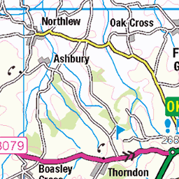
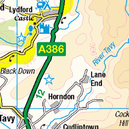
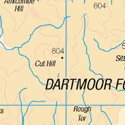
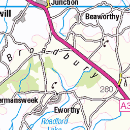
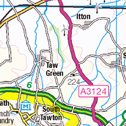
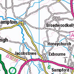
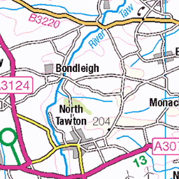
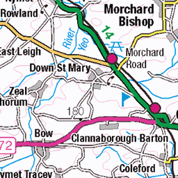
OS Map of High Willhays
Height: 622m / 2041ft • Prominence: 537m / 1762ft • Summit : large cairn on rock tor • Trip reports (hill-bagging)

July 21, 2024-GOPR6928
Prewley Moor - Branscombe's Loaf - Lints Tor - Prewley Moor - 21st - 22nd July 2024
21-Jul-24 • Marklucylockett • flickr
2024 dartmoor dartmoornationalpark devon england gopro goprohero11 july marklockettphotography nationalpark overnightcamp uk usnpb4y1liberatorwreckage unitedkingdom 53873929843

July 21, 2024-GOPR6929
Prewley Moor - Branscombe's Loaf - Lints Tor - Prewley Moor - 21st - 22nd July 2024
21-Jul-24 • Marklucylockett • flickr
2024 dartmoor dartmoornationalpark devon england gopro goprohero11 july marklockettphotography nationalpark overnightcamp uk unitedkingdom okehampton 53874094635

July 21, 2024-GOPR6934
Prewley Moor - Branscombe's Loaf - Lints Tor - Prewley Moor - 21st - 22nd July 2024
21-Jul-24 • Marklucylockett • flickr
2024 dartmoor dartmoornationalpark devon england gopro goprohero11 july marklockettphotography nationalpark overnightcamp uk unitedkingdom 53873684351


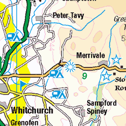
OS Map
This is OS mapping. In some areas, OpenStreetMap shows more footpaths
Spatial NI has online OSNI mapping. Click "Basemap Gallery" (4 squares icon at the top).
Now would be a good time for a cup of tea.

GPX Editor
Record map clicks
Reload map
Photos
Please tag your photos and upload them to the British and Irish Mountains group on Flickr
The other photos have been geo-tagged as on or around the summit. For less busy mountains, it can be a little hit and miss.
July 21, 2024-GOPR6928
Prewley Moor - Branscombe's Loaf - Lints Tor - Prewley Moor - 21st - 22nd July 2024
21-Jul-24 • Marklucylockett • flickr
2024 dartmoor dartmoornationalpark devon england gopro goprohero11 july marklockettphotography nationalpark overnightcamp uk usnpb4y1liberatorwreckage unitedkingdom 53873929843
July 21, 2024-GOPR6929
Prewley Moor - Branscombe's Loaf - Lints Tor - Prewley Moor - 21st - 22nd July 2024
21-Jul-24 • Marklucylockett • flickr
2024 dartmoor dartmoornationalpark devon england gopro goprohero11 july marklockettphotography nationalpark overnightcamp uk unitedkingdom okehampton 53874094635
July 21, 2024-GOPR6934
Prewley Moor - Branscombe's Loaf - Lints Tor - Prewley Moor - 21st - 22nd July 2024
21-Jul-24 • Marklucylockett • flickr
2024 dartmoor dartmoornationalpark devon england gopro goprohero11 july marklockettphotography nationalpark overnightcamp uk unitedkingdom 53873684351


High Wilhays
High Wilhays (198)
10-Jan-16 • Marklucylockett • flickr
2021 dartmoor dartmoornationalpark dartmoornorthtosouth devon england gopro goprohero7 highwilhays marklucylockett nonommweekend october olivermarner planc uk nationalpark dartmoortors tor unitedkingdom southwest moorland moors 54108902312

2877 High Willhays
Started from Meldon Reservoir on a warm and sunny morning but still damp under foot. Prefered Yes Tor. Name:High Willhays Hill number:2877 Height:621m / 2037ft RHB Section:40: Cornwall & Devon Nuttall/Wainwright area:Dartmoor County/UA:Devon (CoU) County (CoH):Devon (CoH) County (CoA):Devon (CoA) Catchment:Torridge Class:Marilyn, Hump, Simm, Hewitt, Nuttall, Historic County Top, Current County/UA Top, Administrative County Top, Buxton & Lewis, Bridge (Ma,Hu,Tu,Sim,Hew,N,CoH,CoU,CoA,BL,Bg,P500) Grid ref:SX 58027 89220 Summit feature:large cairn on rock tor Drop:537m Col:84m ST651119 Survey:Abney level Notes: Devon (1974) administrative county top Devon historic county top Devon current county/UA top
31-May-08 • Dugswell2 • flickr
highwillhays p537 tump marilyn hump simm hewitt nuttall historiccountytop currentcountyuatop administrativecountytop buxtonlewis bridge 32087797257

2877 High Willhays a
31-May-08 • Dugswell2 • flickr
highwillhays p537 tump marilyn hump simm hewitt nuttall historiccountytop currentcountyuatop administrativecountytop buxtonlewis bridge 32087800357

Dinger Tor
Dinger Tor (143) David Gilard, Oliver Marner, Viv Hendra, Paul Niland, Fiona ?, ? Truscott Checking - Torpoint School Ten Tors Training 1988/89
29-Jan-89 • Marklucylockett • flickr
dartmoor dartmoornationalpark devon uk england nationalpark dartmoortors tor unitedkingdom southwest moorland moors 54109050902
Videos
This video is my solo hike up to High Willhays which is the highest point on Dartmoor national park in Devon. I parked at Meldon ...
Join me on a hike to High Willhays, the highest tor on Dartmoor, and the highest point in the south of England! I bag 5 tors on this ...
A circular 10 mile walk on a beautiful Dartmoor day.
Decided to grab the break in the weather and head up for a wild camp on the highest tor in southern England , HIgh Wilhays on ...
Notes
- Data: Database of British and Irish Hills v18.2
- Maps: We use OS mapping for England, Scotland, Wales, and the Isle of Man. Sadly, Channel Islands, Northern (OSNI) and Southern Ireland (OSI) mapping isn't available online, so we use Openstreetmap.