Hills of Britain and Ireland
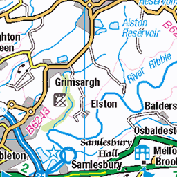
OS Map of White Hill
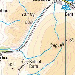
Height: 545m / 1788ft • Prominence: 162m / 531ft • Summit : ground by trig point • Trip reports (hill-bagging)


Sighting Tower near Botton Crag
There are three towers on White Hill, this being the most southerly and the largest. They were used in the construction of the Haweswater Aqueduct that takes water from the Lake District to Manchester. The tunnel is deep underground. Otherwise this is a little visited and lonely spot.
08-Aug-18 • Walruscharmer • flickr
towerstorritorrestourstürme heathermoor sightingtower surveytower whitehill openaccess forestofbowland aonb lancashire england haweswateraqueduct 30073997238

Trig Point on White Hill
Standing at 544 metres upon the lonely summit of White Hill, in the Forest of Bowland. In the background Ingleborough and Gragareth can be seen.
08-Aug-18 • Walruscharmer • flickr
trigpoint triangulationcolumn whitehill fell summit ingleborough gragareth forestofbowland aonb openaccess lancashire england 42134097270

Sighting Tower on White Hill
This is one of three sighting towers on White Hill, although it is rather stunted in height. It was used in the survey for the Haweswater Aqueduct, which carries water from the Lake District to Heaton Park in Manchester. The tunnel is deep below this lonely moorland.
08-Aug-18 • Walruscharmer • flickr
towerstorritorrestourstürme sightingtower surveytower haweswateraqueduct moorland aonb forestofbowland whitehill lancashire england 30074090068

Western Flank on White Hill
Lonely stretch of fell in the Forest of Bowland
08-Aug-18 • Walruscharmer • flickr
fence fellside aonb moorland forestofbowland lancashire england openaccess 42134123510

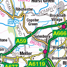
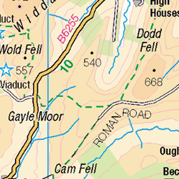
PICT0028 Roman Road, Hard Hill Top
24-Sep-17 • Anand Leo • flickr
romanroad hardhilltop lancashire 26293082358
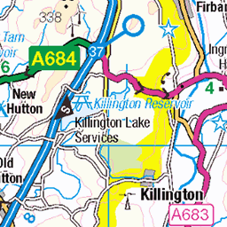
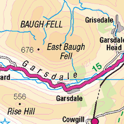
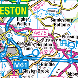
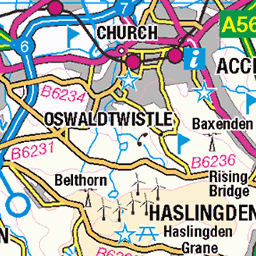
OS Map
This is OS mapping. In some areas, OpenStreetMap shows more footpaths
Spatial NI has online OSNI mapping. Click "Basemap Gallery" (4 squares icon at the top).
Now would be a good time for a cup of tea.
GPX Editor
Record map clicks
Reload map
Photos
Please tag your photos and upload them to the British and Irish Mountains group on Flickr
The other photos have been geo-tagged as on or around the summit. For less busy mountains, it can be a little hit and miss.
Sighting Tower near Botton Crag
There are three towers on White Hill, this being the most southerly and the largest. They were used in the construction of the Haweswater Aqueduct that takes water from the Lake District to Manchester. The tunnel is deep underground. Otherwise this is a little visited and lonely spot.
08-Aug-18 • Walruscharmer • flickr
towerstorritorrestourstürme heathermoor sightingtower surveytower whitehill openaccess forestofbowland aonb lancashire england haweswateraqueduct 30073997238
Trig Point on White Hill
Standing at 544 metres upon the lonely summit of White Hill, in the Forest of Bowland. In the background Ingleborough and Gragareth can be seen.
08-Aug-18 • Walruscharmer • flickr
trigpoint triangulationcolumn whitehill fell summit ingleborough gragareth forestofbowland aonb openaccess lancashire england 42134097270
Sighting Tower on White Hill
This is one of three sighting towers on White Hill, although it is rather stunted in height. It was used in the survey for the Haweswater Aqueduct, which carries water from the Lake District to Heaton Park in Manchester. The tunnel is deep below this lonely moorland.
08-Aug-18 • Walruscharmer • flickr
towerstorritorrestourstürme sightingtower surveytower haweswateraqueduct moorland aonb forestofbowland whitehill lancashire england 30074090068
Western Flank on White Hill
Lonely stretch of fell in the Forest of Bowland
08-Aug-18 • Walruscharmer • flickr
fence fellside aonb moorland forestofbowland lancashire england openaccess 42134123510
PICT0028 Roman Road, Hard Hill Top
24-Sep-17 • Anand Leo • flickr
romanroad hardhilltop lancashire 26293082358

PICT0029 Roman Road, Hard Hill Top
Roman Road, Hard Hill Top, Lancashire
24-Sep-17 • Anand Leo • flickr
romanroad hardhilltop lancashire 26293082408

PICT0030 Roman Road, Hard Hill Top
Roman Road, Croasdale Fell, described by Wainwright as 'the finest moorland walk in Britain'.
24-Sep-17 • Anand Leo • flickr
romanroad hardhilltop lancashire 26293082458

PICT0031 Roman Road, Croasdale Fell
Apparently Alfred Wainwright's ‘finest moorland walk in Britain’.
24-Sep-17 • Anand Leo • flickr
romanroad croasdalefell lancashire 38438686330

2814 White Hill
Third visit to this Marilyn and trig. I expected the hill to be a lot drier than it was after our dry summer but yesterday's rain left the path of sorts beside the fence very wet. Walsh Fell running shoes were great in this sort of going thought. Name:White Hill Hill number:2814 Height:544m / 1785ft Area:36: Lancashire, Cheshire & the Southern Pennines Class:Ma,5 Grid ref:SD 67389 58792 Summit feature:trig point Drop:159m Col:385m SD648587
01-Aug-13 • Dugswell2 • flickr
marilyn tri whitehill p159 9486081678

2814 White Hill 1
Name:White Hill Hill number:2814 Height:544m / 1785ft Area:36: Lancashire, Cheshire & the Southern Pennines Class:Ma,5 Grid ref:SD 67389 58792 Summit feature:trig point Drop:159m Col:385m SD648587
01-Aug-13 • Dugswell2 • flickr
marilyn trig whitehill p159 9483276605

Salter Fell Road (Hornby Road), Hard Hill Top, Forest of Bowland, Lancashire, UK
The www.flickr.com/photos/ministry/3994529383/ sign marks the junction of Hornby Road (following a Roman road at this point) with the (barely discernable) footpath from Whitendale. Just beyond the bend, the track reaches its highest point, at 416 m on the Whitendale/Croasdale watershed. Baxton Fell is in the background, reaching 469 m asl. The slope to the left rises to White Hill, one of Bowland's highest at 544 m. Better bighugelabs.com/flickr/onblack.php?id=5977724928&size=large" rel="nofollow On Black ?
road uk sign track post roman heather salt lancashire moor footpath fell greenlane aonb bowland whitehill forestofbowland whitendale hornbyroad salterfell hardhilltop baxtonfell 5977724928
Videos
10 mile fell run, aprx 1800ft elevation up Clougha Pike, Grit fell and Ward's Stone going anticlockwise from Quernmore carpark ...
Montesa 301rr 2021.
Keasden road is located on the Lancashire and Yorkshire border high up in the hills around Bowland Knotts. It is close to Gisburn ...
Hill climbing on the montesa 301rr at inch perfect trials.
Austwick Amble fell race and the best village fair and a street party ever on the day of Queen Elizabeth II Platinum (70 years) ...
Notes
- Data: Database of British and Irish Hills v18.2
- Maps: We use OS mapping for England, Scotland, Wales, and the Isle of Man. Sadly, Channel Islands, Northern (OSNI) and Southern Ireland (OSI) mapping isn't available online, so we use Openstreetmap.