Hills of Britain and Ireland
OS Map of Fell Head

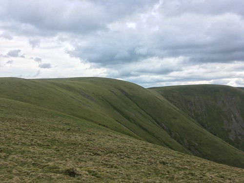
The edge of the Howgills.
Heading back down to the car after our walk up to Fell head.
10-May-23 • A tramp in the hills • flickr
howgill m6 52893937319


From Top to Bottom
As we headed north from Calders over Bram Rigg Top to The Calf, our high point of the day, the weather closed in and the rain started. Fortunately, as we descended White Fell to Chapel Beck, things improved
20-Oct-19 • RoystonVasey • flickr
canon eos 77d efs 18135mm f3556 is usm cumbria ydnp yorkshire dales national park howgill fells sedbergh calders bram rigg top calf white fell chapel beck 51954244834

OS Map
This is OS mapping. In some areas, OpenStreetMap shows more footpaths
Spatial NI has online OSNI mapping. Click "Basemap Gallery" (4 squares icon at the top).
Now would be a good time for a cup of tea.
GPX Editor
Record map clicks
Reload map
Photos
Please tag your photos and upload them to the British and Irish Mountains group on Flickr
The other photos have been geo-tagged as on or around the summit. For less busy mountains, it can be a little hit and miss.
The edge of the Howgills.
Heading back down to the car after our walk up to Fell head.
10-May-23 • A tramp in the hills • flickr
howgill m6 52893937319
From Top to Bottom
As we headed north from Calders over Bram Rigg Top to The Calf, our high point of the day, the weather closed in and the rain started. Fortunately, as we descended White Fell to Chapel Beck, things improved
20-Oct-19 • RoystonVasey • flickr
canon eos 77d efs 18135mm f3556 is usm cumbria ydnp yorkshire dales national park howgill fells sedbergh calders bram rigg top calf white fell chapel beck 51954244834

Foot of Black Force, Carlin Gill, Howgill Fells, Yorkshire Dales National Park near Tebay, Cumbria, UK
Another old favourite/adversary – the number of times I've failed to visually separate that tree from its background.... This small step in Carlingill Beck, more notable for its photogenic setting than its magnitude, lies just downstream of Black Force, the ~100 m cascade waterfall where Little Ulgill Beck meets the main channel. The blocky Silurian gritstone underlying the Howgill Fells is rarely visible at the grassy surface, but the exposures are usually worth seeing!
waterfall carlingillbeck carlingill howgillfells yorkshire dales nationalpark tebay cumbria uk cascade stream howgill tree boulder fern blackforce carlinggill 52548413309

Upper Carlin Gill, Howgill Fells, Yorkshire Dales National Park near Tebay, Cumbria, UK
It's difficult for a photo to demonstrate the scale of the steep slopes lining the upper end of Carlin Gill (and most other Howgill valleys), but those trees beside Carlingill Beck are indeed tree-sized – they're not huge, but they're not bushes! I suppose they have a sheltered, well-water location, with thin glacial soil improved by nutrients washed downhill. Maybe statistics express it better. The very flat slope to the left of the trees ascends ~125 m from the Beck to the ridgetop, maintaining a 1-in-1.76 incline for a horizontal distance of 220 m. No wonder the sheep walk single-file on narrow terraces. Even then, the end of the flat section isn't the top, which is beyond a further, teasingly convex slope. The furthest ridge on the left descends rightwards from Knowles (461 m) towards Back Balk. The nearer ridge is simply on the side of Carlin Gill, between the tributary gulleys of Small Gill and Heskaw Gill. The right bank is the sparser-vegetated Screes of Black Force. The hill in the background is Greyrigg Pike, 4 km away.
sheep carlingill howgillfells sedbergh yorkshire dales nationalpark cumbria uk carlingillbeck knowles smallgill heskawgill screes blackforce tree valley howgill carlinggill 50706676768

Tree beside Black Force, Carlin Gill, Howgill Fells near Sedbergh, Yorkshire Dales National Park, Cumbria, UK
Directly behind this tree on Ulgill Rigg, Little Ulgill Beck falls ~100 m vertically (in a cascade, not single drop) over Black Force to join Carlingill Beck, visible at the lower right. The steep slope on the right, facing the waterfall, is the Screes of Black Force. It's difficult for a photo to demonstrate the scale of the slopes lining the upper end of Carlin Gill (and most other Howgill valleys), but those trees beside the beck are indeed fully tree-sized – they're not huge, but they're not bushes! Behind, two tributaries join the main beck: Small Gill and Heskaw Gill. The haziness behind the tree indicates that they were being fed by new rain at the time of the photo – which was heading my way.... The left ridge continues as Back Balk to Gallows Hill overlooking Fairmile Road (a single track Roman road) and the Lune Gorge. Beyond is Greyrigg Pike, 4 km away in the Lake District National Park, and more rain largely obscuring Borrowdale. Beyond the Screes of Black Force, the slope on the right rises to Uldale Head, forming the northern side of Carlin Gill. Blease Fell is at the end, 2½ km away.
blackforce carlingill howgillfells yorkshire dales nationalpark cumbria uk silurian geology exposure sandstone shale bedding howgill fell beck lunegorge bleasefell greyrigg pike borrowdale backbalk ashsteadfell lakedistrict sedbergh howgills grass moorland hill valley 53645431603

In the Howgills
Olympus OM1, Ektachrome E64, slide scanned, digital development in Lightroom.
19-Aug-78 • Ed Fulton • flickr
cumbria e64 ektachrome england film howgillfells olympusom1 uk sedbergh unitedkingdom er 52340108431
Videos
Boxing Day and a la'al trip south down the M6 passed my local snow capped Lake District Mountains to visit The beautiful and ...
The Howgill Fells 2000's is a new challenge walk devised by Mark Reid that takes in all nine summits over 2000-ft (610 metres) in ...
A couple of days well spent. Headspace away from London and work. Riding trails on a totally inappropriate bike is fun as fnck but ...
A fifteen mile circuit in the Howgills on a glorious January Saturday. The Lakeland Fells, Morecambe Bay, Ingleborough - all the ...
An 11 mile walk from the Cross Keys Temperance Inn. The route heads north and climbs over Harter Fell before turning east and ...
Notes
- Data: Database of British and Irish Hills v18.2
- Maps: We use OS mapping for England, Scotland, Wales, and the Isle of Man. Sadly, Channel Islands, Northern (OSNI) and Southern Ireland (OSI) mapping isn't available online, so we use Openstreetmap.