Hills of Britain and Ireland
OS Map of Raven's Barrow (Cartmel Fell)

May 27, 2023 0010
architecture blackwhite cameraslenses flickr fujifilmxpro3 urinals voigtländernokton23mmf12xmount yewtreebarn camera:make=fujifilm geocountry exif:lens=voigtlandernokton23mmf12 geo:lon=289948892768 camera:model=xpro3 geo:lat=54272678711292 exif:isospeed=640 geostate geocity geolocation exif:make=fujifilm exif:focallength=23mm exif:model=xpro3 exif:aperture=ƒ28 52934820649

2023-02-24 Winster and Lyth Valley ride
www.bench-marks.org.uk/bm185589" rel="noreferrer nofollow www.bench-marks.org.uk/bm185589
24-Feb-23 • Houlie - Windermere • flickr
52709352223


Rivet benchmark - Lindale - Tarn Green Road
www.bench-marks.org.uk/bm185613" rel="noreferrer nofollow www.bench-marks.org.uk/bm185613
24-Feb-23 • Houlie - Windermere • flickr
52708955411

Cartmel Fell Church - Inside
Looking from the altar to the font which dates from the early eighteenth century.
11-Nov-22 • ARG_Flickr • flickr
52498590216
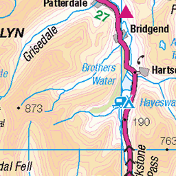
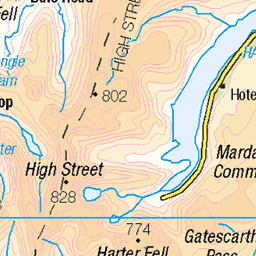
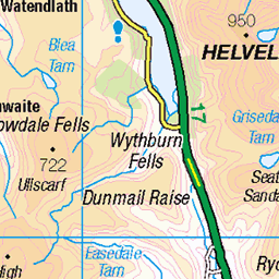
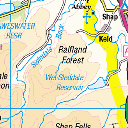
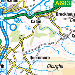
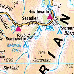
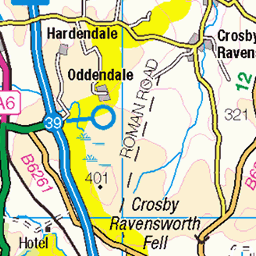
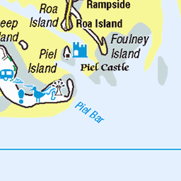
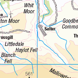
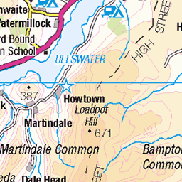
OS Map
This is OS mapping. In some areas, OpenStreetMap shows more footpaths
Spatial NI has online OSNI mapping. Click "Basemap Gallery" (4 squares icon at the top).
Now would be a good time for a cup of tea.


GPX Editor
Record map clicks
Reload map
Photos
Please tag your photos and upload them to the British and Irish Mountains group on Flickr
The other photos have been geo-tagged as on or around the summit. For less busy mountains, it can be a little hit and miss.
May 27, 2023 0010
architecture blackwhite cameraslenses flickr fujifilmxpro3 urinals voigtländernokton23mmf12xmount yewtreebarn camera:make=fujifilm geocountry exif:lens=voigtlandernokton23mmf12 geo:lon=289948892768 camera:model=xpro3 geo:lat=54272678711292 exif:isospeed=640 geostate geocity geolocation exif:make=fujifilm exif:focallength=23mm exif:model=xpro3 exif:aperture=ƒ28 52934820649
2023-02-24 Winster and Lyth Valley ride
www.bench-marks.org.uk/bm185589" rel="noreferrer nofollow www.bench-marks.org.uk/bm185589
24-Feb-23 • Houlie - Windermere • flickr
52709352223
Rivet benchmark - Lindale - Tarn Green Road
www.bench-marks.org.uk/bm185613" rel="noreferrer nofollow www.bench-marks.org.uk/bm185613
24-Feb-23 • Houlie - Windermere • flickr
52708955411
Cartmel Fell Church - Inside
Looking from the altar to the font which dates from the early eighteenth century.
11-Nov-22 • ARG_Flickr • flickr
52498590216

Remembered
The memorial in Cartmel Fell churchyard above the Winster Valley just before 11 a.m. on the 11th November 2022.
11-Nov-22 • ARG_Flickr • flickr
52493499083

Cartmel Fell Church - Outside
A ceramic plaque created to celebrate five hundred years since the chapel of ease was founded. The artist is Hans Ullrich with assistance from local children. Several scenes of local activities form the centrepiece with the chap on the right being St. Anthony.
06-Oct-22 • ARG_Flickr • flickr
52498590076

Cartmel Fell Church
St. Anthonys is another Winster valley church serving a scattered community. It was founded at the start of the sixteenth century and like St Pauls at Witherslack it was created as a chapel-of-ease this time to Cartmel Priory.
06-Oct-22 • ARG_Flickr • flickr
52498590356

St Anthony's Church Cartmel Fell Cumbria
Lych Gate St Anthony's is a small stone-built church. Wooden plaque inside celebrates 1504 to 2004 of church standing here. Still in use, weekly. Hardly changed from day it was rebuilt. A very serene, quiet place. The Lych Gate commemorate the fallen during WW2 1939-45. Beside path from Lych Gate to entrance is a green slate memorial to WW1 parishioners. St Anthony's was built as a satellite church to Cartmel Priory which is many miles away, but shares similar village name, Cartmel. The church was restored in 1911 by John Curwen. The church is listed as Grade 1.
14-Jul-21 • Kingsley Allison • flickr
stanthonyschurch cartmelfell church churchcrawling chancel churchofengland cumbria historicchurches holyplace christianity worship lakedistrict nikon nikond7200 listedbuildings 1 grade1 graveyards lychgate 51323431328
Videos
As the covid-19 lockdown continues we're forced to do only local walks. Fortunately Finn and I have some very beautiful areas to ...
The motor vessel Teal was built by Vickers Armstrong of Barrow in Furness and transported in sections to the slipway at lakeside ...
Notes
- Data: Database of British and Irish Hills v18.2
- Maps: We use OS mapping for England, Scotland, Wales, and the Isle of Man. Sadly, Channel Islands, Northern (OSNI) and Southern Ireland (OSI) mapping isn't available online, so we use Openstreetmap.