Hills of Britain and Ireland
OS Map of Stickle Pike
Height: 375m / 1230ft • Prominence: 116m / 381ft • Summit : large cairn • Trip reports (hill-bagging)

St John the Baptist Methodist Church, Ulpha
16-Mar-24 • Paul Austin Murphy • flickr
ulpha 53592698695


OS Map
This is OS mapping. In some areas, OpenStreetMap shows more footpaths
Spatial NI has online OSNI mapping. Click "Basemap Gallery" (4 squares icon at the top).
Now would be a good time for a cup of tea.
GPX Editor
Record map clicks
Reload map
Photos
Please tag your photos and upload them to the British and Irish Mountains group on Flickr
The other photos have been geo-tagged as on or around the summit. For less busy mountains, it can be a little hit and miss.
St John the Baptist Methodist Church, Ulpha
16-Mar-24 • Paul Austin Murphy • flickr
ulpha 53592698695
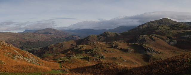

Lickle Valley
with the Duddon Estuary beyond
broughtonmills hovelknott evening duddonestuary farmland outcrop panasonicgx8 lumix 53390288551

The Duddon Estuary
from the edge of the Dunnerdale fells
eveninglight dunnerdale duddonestuary licklevalley shadows sea clouds wpd24nature 53438860264

England 2023 09-009
OLYMPUS DIGITAL CAMERA
15-Jun-23 • stollenvernichter • flickr
ulpha copelanddistrict england motorrad tour motorradtour 53038470255
Videos
thelakedistrict #pikeofblisco #walkinglakes This is Day 2 of 6 where we spend some time in The Lake District Walking up some of ...
lakesmtb Music used in this video Copyright owners SME, WMG, The Richmond Organization (TRO) On behalf of: ...
Three new Wainwrights climbed on a very eventful day starting by my 'hair' raising drive down the Wrynose Pass to park at the ...
Stunning views, fallen trees & a poignant memorial in the Southern Fells on Armistice Day 2023. This 10.5 mile walk includes ...
An epic for all the wrong reasons! It looked good on paper, a figure of eight route starting at Kiln Bank Cross. The first part ...
Notes
- Data: Database of British and Irish Hills v18.2
- Maps: We use OS mapping for England, Scotland, Wales, and the Isle of Man. Sadly, Channel Islands, Northern (OSNI) and Southern Ireland (OSI) mapping isn't available online, so we use Openstreetmap.