Hills of Britain and Ireland
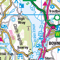
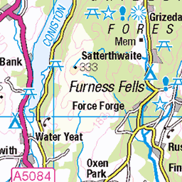
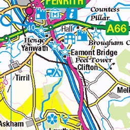
OS Map of High Pike (Scandale)
Height: 657m / 2156ft • Prominence: 1m / 3ft • Summit : small cairn on rock outcrop • Trip reports (hill-bagging)


The Southern Part of the Fairfield Horseshoe
Looking toward High Pike.
06-Feb-25 • Paul Austin Murphy • flickr
54313538302

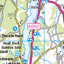
Coniston Water
From between High Pike and Dove Crag. With the Irish Sea in the distance.
06-Feb-25 • Paul Austin Murphy • flickr
54312171793
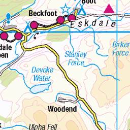
OS Map
This is OS mapping. In some areas, OpenStreetMap shows more footpaths
Spatial NI has online OSNI mapping. Click "Basemap Gallery" (4 squares icon at the top).
Now would be a good time for a cup of tea.


GPX Editor
Record map clicks
Reload map
Photos
Please tag your photos and upload them to the British and Irish Mountains group on Flickr
The other photos have been geo-tagged as on or around the summit. For less busy mountains, it can be a little hit and miss.
The Southern Part of the Fairfield Horseshoe
Looking toward High Pike.
06-Feb-25 • Paul Austin Murphy • flickr
54313538302
Coniston Water
From between High Pike and Dove Crag. With the Irish Sea in the distance.
06-Feb-25 • Paul Austin Murphy • flickr
54312171793


Videos
A walk up Low and High pikes taking in Dove Crag with a return via Scandale.
A slow 360 degree panorama from the summit of Low Pike, one of the 8 fells that make up the Fairfield Horseshoe, the classic ...
A great walk over 3 Wainwrights. Low Pike, High Pike & Dove Crag. Atmospheric conditions on the hills as Autumn creeps in!
A walk up Low and High pikes taking in Dove Crag with a return via Scandale.
A slow 360 degree panorama from the summit of Low Pike, one of the 8 fells that make up the Fairfield Horseshoe, in the Eastern ...
Notes
- Data: Database of British and Irish Hills v18.2
- Maps: We use OS mapping for England, Scotland, Wales, and the Isle of Man. Sadly, Channel Islands, Northern (OSNI) and Southern Ireland (OSI) mapping isn't available online, so we use Openstreetmap.