Hills of Britain and Ireland
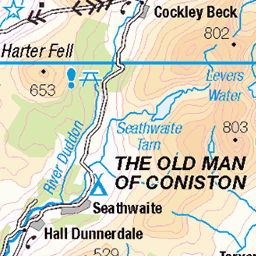
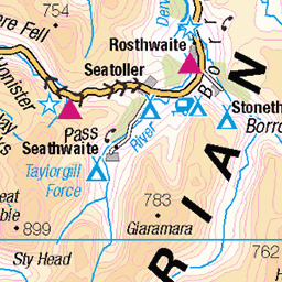
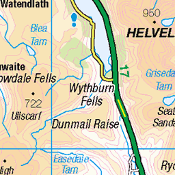
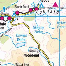
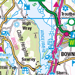
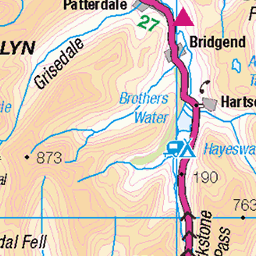
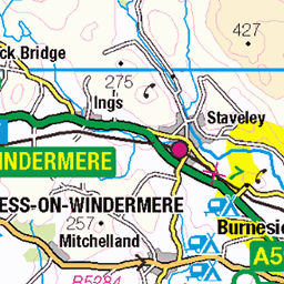
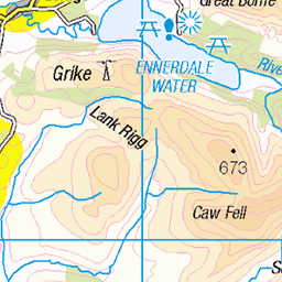
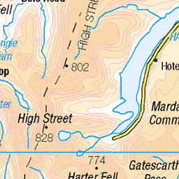
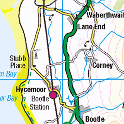
OS Map of Lingmoor Fell (Brown How)
Height: 470m / 1542ft • Prominence: 248m / 814ft • Summit : rock 2m N of cairn • Trip reports (hill-bagging)

Little Langdale
Valley tucked away in a semi circle of fells at the foot of Wrynose Pass. Lingmoor, Pike O' Blisco and Wetherlam stand guard over this secretive of dales.
27-Feb-25 • Walruscharmer • flickr
tarn smallsecretivevalley lingmoor wetherlam lakelandfells lakedistrict nationalpark cumbria england 54376185244

Blea Tarn.
Blea Tarn in the Lake District.
27-Feb-25 • calypso182 • flickr
clouds grass landscape mountain outdoors rocks trees water lake lakedistrict bleatarn fence england stones 54371611946

Blea Tarn
25-Feb-25 • CdL Creative • flickr
bleatarn canonr8 cdlcreative cumbria england la22 lakedistrict stevehutchings geo:lat=544279 geo:lon=30924 geotagged hdr ambleside unitedkingdom 54354162270


photo
08-Dec-24 • Marie-Laure Even • flickr
landscape winter lakedistrict olympusem5markii cumbria stonewall birkfellman wetherlam fellfootfarm countryside wilderness wild marielaureeven tree travel cloud mountain 2024 lakedistrictnationalpark nature england europe uk field arbre campagne champ fjall hiver montagne murenpierre nuage paysage royaumeuni unitedkingdom voyage гора природа 54323537816
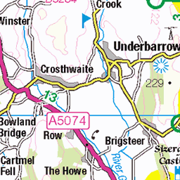
OS Map
This is OS mapping. In some areas, OpenStreetMap shows more footpaths
Spatial NI has online OSNI mapping. Click "Basemap Gallery" (4 squares icon at the top).
Now would be a good time for a cup of tea.

GPX Editor
Record map clicks
Reload map
Photos
Please tag your photos and upload them to the British and Irish Mountains group on Flickr
The other photos have been geo-tagged as on or around the summit. For less busy mountains, it can be a little hit and miss.
Little Langdale
Valley tucked away in a semi circle of fells at the foot of Wrynose Pass. Lingmoor, Pike O' Blisco and Wetherlam stand guard over this secretive of dales.
27-Feb-25 • Walruscharmer • flickr
tarn smallsecretivevalley lingmoor wetherlam lakelandfells lakedistrict nationalpark cumbria england 54376185244
Blea Tarn.
Blea Tarn in the Lake District.
27-Feb-25 • calypso182 • flickr
clouds grass landscape mountain outdoors rocks trees water lake lakedistrict bleatarn fence england stones 54371611946
Blea Tarn
25-Feb-25 • CdL Creative • flickr
bleatarn canonr8 cdlcreative cumbria england la22 lakedistrict stevehutchings geo:lat=544279 geo:lon=30924 geotagged hdr ambleside unitedkingdom 54354162270
photo
08-Dec-24 • Marie-Laure Even • flickr
landscape winter lakedistrict olympusem5markii cumbria stonewall birkfellman wetherlam fellfootfarm countryside wilderness wild marielaureeven tree travel cloud mountain 2024 lakedistrictnationalpark nature england europe uk field arbre campagne champ fjall hiver montagne murenpierre nuage paysage royaumeuni unitedkingdom voyage гора природа 54323537816

photo
02-Dec-24 • Marie-Laure Even • flickr
hike england winter panda lakedistrict olympusem5markii bordercollie lingmoorfellandsidepikehike nature wild marielaureeven cumbria travel cloud landscape 2024 lakedistrictnationalpark wilderness dog europe uk mountain chien fjall hiver montagne nuage paysage royaumeuni unitedkingdom voyage гора природа 54296613304

Treding Water
Half mile to go to my destination of Dungeon Ghyll Force an Impressive 40 foot waterfall fed by Dungeon Ghyll. This site was loved by Victorian poets and is still as spectacular today. Great Langdale, Ambleside, Cumbria, LA22 9JU
21-Aug-19 • Oneterry AKA Terry Kearney • flickr
dungeonghyll dungeonghyllforce waterfall water waterway watercourse elterwater chapelstile lakedistrict ambleside cumbria august summer summerrain trees tree river clouds hillside hills hill foothill fields field farmland farm animals canon canoneos1dmarkiv daylight day explore europe england geotagged kearney skyline sky skies landscape nature oneterry outdoor terrykearney weather 2025 greatlangdale langdalepikes pikes 54298369329

Mickleden Valley
Mickleden Valley in Langdale
17-Oct-16 • 19Lynky44 • flickr
lakes16th18thoctober2016 ambleside england unitedkingdom 54297141976

Early morning light , Blea Tarn
One from the archives take back in 2013.
13-Jul-13 • Back and posting again. • flickr
54284283512
Videos
A great walk up Lingmoor Fell above the Langdale valley. Fantastic views in all directions. Music from www.bensound.com ...
GPX Download Of Route... https://drive.google.com/file/d/1NSN5R_0cD6portPV1YPGy3PRij3scXHd/view?usp=drivesdk ...
Howdy Doody. In this video we go exploring Blea Tarn and then go for a Hike on Lingmoor Fell where we discover "The Wall" this ...
Almost too old now to tackle the higher peaks but many of the Wainwrights are still within reach. Here me and the young codger ...
Come along with me on this atmospheric walk in the Lake District National Park from the beautiful Langdale Valley. I parked at the ...
Notes
- Data: Database of British and Irish Hills v18.2
- Maps: We use OS mapping for England, Scotland, Wales, and the Isle of Man. Sadly, Channel Islands, Northern (OSNI) and Southern Ireland (OSI) mapping isn't available online, so we use Openstreetmap.