Hills of Britain and Ireland
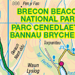
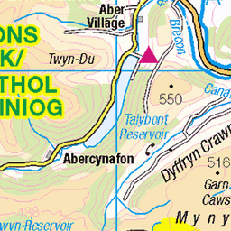
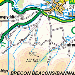
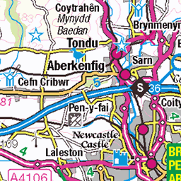
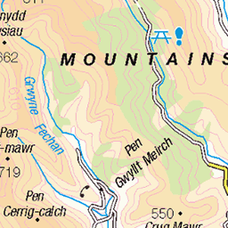
OS Map of Mynydd Gethin
Height: 492m / 1614ft • Prominence: 149m / 489ft • Summit : embedded flat rock on S side of artificial raised platform • Trip reports (hill-bagging)


20240113-120842
Llettyshenkin House, Aberdare, Wales
architecturebuildinghouse natureplanttree natureseasonwinter transportroaddriveway aberdare midglamorgan walesuk architecture building driveway house nature plant road season transport tree winter 53503223343

20240113-123630
Mynydd Merthyr, Cwmbach, Aberdare, Wales
naturelandscapehill natureplanttree natureseasonwinter techniquerecession aberdare midglamorgan walesuk hill landscape nature plant recession season technique tree winter 53461864738
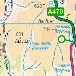
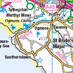
OS Map
This is OS mapping. In some areas, OpenStreetMap shows more footpaths
Spatial NI has online OSNI mapping. Click "Basemap Gallery" (4 squares icon at the top).
Now would be a good time for a cup of tea.

GPX Editor
Record map clicks
Reload map
Photos
Please tag your photos and upload them to the British and Irish Mountains group on Flickr
The other photos have been geo-tagged as on or around the summit. For less busy mountains, it can be a little hit and miss.
20240113-120842
Llettyshenkin House, Aberdare, Wales
architecturebuildinghouse natureplanttree natureseasonwinter transportroaddriveway aberdare midglamorgan walesuk architecture building driveway house nature plant road season transport tree winter 53503223343
20240113-123630
Mynydd Merthyr, Cwmbach, Aberdare, Wales
naturelandscapehill natureplanttree natureseasonwinter techniquerecession aberdare midglamorgan walesuk hill landscape nature plant recession season technique tree winter 53461864738

20240113-124925
Mynydd Merthyr, Cwmbach, Aberdare, Wales
architecturewallstone naturelandscapehill natureplanttree natureseasonwinter natureweathermist aberdare midglamorgan walesuk architecture hill landscape mist nature plant season stone tree wall weather winter 53461841123

20240113-130028
Mynydd Merthyr, Cwmbach, Aberdare, Wales
naturelandscapehill natureplanttree natureseasonwinter shapegnarled aberdare midglamorgan walesuk gnarled hill landscape nature plant season shape tree winter 53463992949

20240113-135438
Mynydd Merthyr, Cwmbach, Aberdare, Wales
naturelandscapehill natureplanttree natureseasonwinter placetown techniquepanoramic aberdare midglamorgan walesuk hill landscape nature panoramic place plant season technique town tree winter 53462072294

Looking down into the cynon valley from the top of cefnpennar
08-Nov-20 • pasti , life and times of ..... • flickr
walking 50580718712

2291 Mynydd Gethin
Parked at the top of the minor road at Ffynnon-y-gôg then used the ENE path to gain access to the hill passing some spoil heaps on my way to the forest. Trig at summit within view of the top of Bike Park Wales. Area also called Mynydd Merthyr. Name:Mynydd Gethin Hill number: 2291 Height:491m / 1611ft Parent (Ma/M):2237 Fan Fawr Section: 32C: Neath to Chepstow County/UA: Rhondda Cynon Taff (CoU) Class:Hump, Tump (400-499m), Submarilyn Grid ref: SO 04424 02518 Summit feature:trig point Drop: 145m Col: 346m SO003103
03-Jul-15 • Dugswell2 • flickr
hump trigpoint tump p145 submarilyn mynyddgethin 23639095722

2291 Mynydd Gethin a
Parked at the top of the minor road at Ffynnon-y-gôg then used the ENE path to gain access to the hill passing some spoil heaps on my way to the forest. Trig at summit within view of the top of Bike Park Wales. Area also called Mynydd Merthyr. Name:Mynydd Gethin Hill number: 2291 Height:491m / 1611ft Parent (Ma/M):2237 Fan Fawr Section: 32C: Neath to Chepstow County/UA: Rhondda Cynon Taff (CoU) Class:Hump, Tump (400-499m), Submarilyn Grid ref: SO 04424 02518 Summit feature:trig point Drop: 145m Col: 346m SO003103
03-Jul-15 • Dugswell2 • flickr
hump trigpoint tump p145 submarilyn mynyddgethin 23379673889
Videos
Mynydd Aberdar is a 457m hill above Merthyr Tydfil, it has incredible views of the Brecon Beacons yet is rarely walked and very ...
R.C.T council and Beddau scumbags once again caused my dog a nasty injury while out walking.
Perhaps this slideshow/video is only of interest those who have either lived in the village or have friends who did.There are some ...
Notes
- Data: Database of British and Irish Hills v18.2
- Maps: We use OS mapping for England, Scotland, Wales, and the Isle of Man. Sadly, Channel Islands, Northern (OSNI) and Southern Ireland (OSI) mapping isn't available online, so we use Openstreetmap.