Hills of Britain and Ireland
Map of Knocknafallia (Dillon GR)
Height: 666m / 2185ft • Prominence: 3m / 10ft • Summit : rock near windshelter • Trip reports (hill-bagging)

Sunrise
Sunrise on the trail. So much rain has fallen the last few days, the Knockmealdowns are great for hiking as they're always dry, great when you don't fancy walking through a mucky soup.
01-Oct-21 • ClosingAccountJW • flickr
knockmeal knockmealdowns knocknanask landscape outdoor path sun sunrise tipperary green hiking ireland mountain munster waterford 51542493815

Looking down on Suir Valley (Σxplore)
Freezing here on top of Knocknagnauv mountain, with the wind blowing from the North West, air coming from Greenland, certainly is a change from recent weather.
01-Oct-21 • ClosingAccountJW • flickr
knockanare knockmealdowns mountain ireland waterford tipperary knocknagnauv 51538926810

The Forgotten Wall
Famine wall overgrown in heather and crumbling. Somewhere between Knocknafallia (background right) and Knocknagnauv (behind). The wall is the border between Tipperary and Waterford.
31-Aug-21 • ClosingAccountJW • flickr
crepuscularrays flowersplants knockmeal knockmealdowns knocknafallia knocknagnauv landscape outdoor rocks sunrise tipperary clouds forgotten green hiking ireland mountain munster rays sky stones wall waterford 51415291506
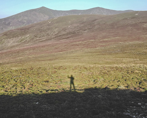
The Shadow
Early morning just after descending from Knocknafallia mountain (666.5m) in the Knockmealdown mountain range. In the background rises the highest peaks, Knockmealdown on the left and Knockmoylan to the right.
18-Sep-20 • ClosingAccountJW • flickr
knockmealdown knockmoylan knocknafallia landscape outdoor rocks green heather hiking ireland mountain munster shadow waterford 50361328512


Open Street Map
This is Open Street Map mapping. Sorry, (topographic) OSNI/Channel Islands/OSI mapping is not available online
Spatial NI has online OSNI mapping. Click "Basemap Gallery" (4 squares icon at the top).
Now would be a good time for a cup of tea.
GPX Editor
Record map clicks
Reload map
Photos
Please tag your photos and upload them to the British and Irish Mountains group on Flickr
The other photos have been geo-tagged as on or around the summit. For less busy mountains, it can be a little hit and miss.
Sunrise
Sunrise on the trail. So much rain has fallen the last few days, the Knockmealdowns are great for hiking as they're always dry, great when you don't fancy walking through a mucky soup.
01-Oct-21 • ClosingAccountJW • flickr
knockmeal knockmealdowns knocknanask landscape outdoor path sun sunrise tipperary green hiking ireland mountain munster waterford 51542493815
Looking down on Suir Valley (Σxplore)
Freezing here on top of Knocknagnauv mountain, with the wind blowing from the North West, air coming from Greenland, certainly is a change from recent weather.
01-Oct-21 • ClosingAccountJW • flickr
knockanare knockmealdowns mountain ireland waterford tipperary knocknagnauv 51538926810
The Forgotten Wall
Famine wall overgrown in heather and crumbling. Somewhere between Knocknafallia (background right) and Knocknagnauv (behind). The wall is the border between Tipperary and Waterford.
31-Aug-21 • ClosingAccountJW • flickr
crepuscularrays flowersplants knockmeal knockmealdowns knocknafallia knocknagnauv landscape outdoor rocks sunrise tipperary clouds forgotten green hiking ireland mountain munster rays sky stones wall waterford 51415291506
The Shadow
Early morning just after descending from Knocknafallia mountain (666.5m) in the Knockmealdown mountain range. In the background rises the highest peaks, Knockmealdown on the left and Knockmoylan to the right.
18-Sep-20 • ClosingAccountJW • flickr
knockmealdown knockmoylan knocknafallia landscape outdoor rocks green heather hiking ireland mountain munster shadow waterford 50361328512


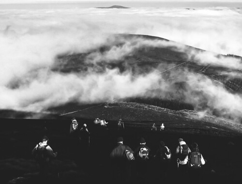
Into the Light
Hikers descending Knocknafallia.
29-Nov-10 • ClosingAccountJW • flickr
autumn blackandwhite blackwhite fall knockmealdown knocknafallia landscape outdoor rocks bw clouds hiking ireland mountain munster sky stones waterford 50898293327
Videos
None found
Notes
- Data: Database of British and Irish Hills v18.2
- Maps: We use OS mapping for England, Scotland, Wales, and the Isle of Man. Sadly, Channel Islands, Northern (OSNI) and Southern Ireland (OSI) mapping isn't available online, so we use Openstreetmap.