Hills of Britain and Ireland
OS Map of South Barrule
Height: 483m / 1585ft • Prominence: 436m / 1430ft • Summit : trig point • Trip reports (hill-bagging)

south barule
an easy route to follow as the path goes straight to the top
25-Apr-22 • Ron Layters • flickr
southbarule path hill moorland landscape manx dalby isleofman crowndependency unitedkingdom slidefilmthenscanned slide transparency fujichrome velvia canoneos300v canon eos300v rebelti ronlayters 52028656393

1948 South Barrule
Name:South Barrule Hill number:1948 Height:483m / 1585ft RHB Section:29: Isle of Man County/UA:Isle of Man (CoU) Island:Isle of Man Class:Marilyn, Hump, Tump (400-499m), Clem Grid ref:SC 25773 75920 Summit feature:trig point Drop:436m Col:47m SC298807
19-Sep-21 • Dugswell2 • flickr
isleofman 15052002 southbarrule marilyn hump clem tump p436 trigpoint 51493336415

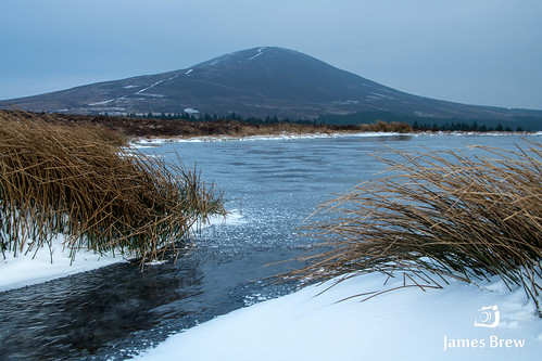
Frozen Lake
To watch how I captured this shot watch my video diary of the trip: youtu.be/USkOCVW78tw" rel="nofollow youtu.be/USkOCVW78tw The “Beast from the East” winter weather dumped heavy snow over pretty much the whole of Britain…apart of course the Isle of Man! We still however got the brutally cold sub-zero conditions and a tiny dusting of the white stuff! This image was taken at a small pond which sits at the foot of South Barrule. The freezing weather meant that the water was beautifully iced over with very thick ice which is quite a rarity here. I struggled to find compositions I was happy with but this one stood out for me. The two bunches of snow covered reeds with the tongue of ice slipping in-between made for an interesting foreground with the imposing South Barrule looming in the background. This shot makes me feel cold just looking at it…which is fitting as I’ve probably only just thawed out properly from this shoot a week later!! Please visit my YouTube channel: www.youtube.com/jamesbrewphoto" rel="nofollow www.youtube.com/jamesbrewphoto Please visit www.jamesbrew.com" rel="nofollow www.jamesbrew.com for my website and full Portfolio. Follow me on Instagram @ www.instagram.com/jamesbrewphoto/" rel="nofollow jamesbrewphoto Follow me on Twitter @ twitter.com/JamesBrewPhoto" rel="nofollow jamesbrewphoto Find me on Facebook @ www.facebook.com/pages/James-Brew-Photography/120333847993616" rel="nofollow /jamesbrewphoto
03-Mar-18 • James Brew (www.jamesbrew.com) • flickr
isleofman landscapephotography manx jamesbrew ice snow winter mountains hiking frozen britain uk nature scenery 25853835067

Cringle Reservoir
13-Feb-18 • cabmanstu • flickr
isleofman cringle reservoir reflections landscape landscapephotography 40240703512

Cringle reservoir (13)
A trip round Cringle. I managed to get a few nice shots before the hail stones arrived.
nature canon walking photography walks dam scenic reservoir isleofman manx weir iom cringlereservoir ellanvannin canon1100d 23240948402
OS Map
This is OS mapping. In some areas, OpenStreetMap shows more footpaths
Spatial NI has online OSNI mapping. Click "Basemap Gallery" (4 squares icon at the top).
Now would be a good time for a cup of tea.
GPX Editor
Record map clicks
Reload map
Photos
Please tag your photos and upload them to the British and Irish Mountains group on Flickr
The other photos have been geo-tagged as on or around the summit. For less busy mountains, it can be a little hit and miss.
south barule
an easy route to follow as the path goes straight to the top
25-Apr-22 • Ron Layters • flickr
southbarule path hill moorland landscape manx dalby isleofman crowndependency unitedkingdom slidefilmthenscanned slide transparency fujichrome velvia canoneos300v canon eos300v rebelti ronlayters 52028656393
1948 South Barrule
Name:South Barrule Hill number:1948 Height:483m / 1585ft RHB Section:29: Isle of Man County/UA:Isle of Man (CoU) Island:Isle of Man Class:Marilyn, Hump, Tump (400-499m), Clem Grid ref:SC 25773 75920 Summit feature:trig point Drop:436m Col:47m SC298807
19-Sep-21 • Dugswell2 • flickr
isleofman 15052002 southbarrule marilyn hump clem tump p436 trigpoint 51493336415
Frozen Lake
To watch how I captured this shot watch my video diary of the trip: youtu.be/USkOCVW78tw" rel="nofollow youtu.be/USkOCVW78tw The “Beast from the East” winter weather dumped heavy snow over pretty much the whole of Britain…apart of course the Isle of Man! We still however got the brutally cold sub-zero conditions and a tiny dusting of the white stuff! This image was taken at a small pond which sits at the foot of South Barrule. The freezing weather meant that the water was beautifully iced over with very thick ice which is quite a rarity here. I struggled to find compositions I was happy with but this one stood out for me. The two bunches of snow covered reeds with the tongue of ice slipping in-between made for an interesting foreground with the imposing South Barrule looming in the background. This shot makes me feel cold just looking at it…which is fitting as I’ve probably only just thawed out properly from this shoot a week later!! Please visit my YouTube channel: www.youtube.com/jamesbrewphoto" rel="nofollow www.youtube.com/jamesbrewphoto Please visit www.jamesbrew.com" rel="nofollow www.jamesbrew.com for my website and full Portfolio. Follow me on Instagram @ www.instagram.com/jamesbrewphoto/" rel="nofollow jamesbrewphoto Follow me on Twitter @ twitter.com/JamesBrewPhoto" rel="nofollow jamesbrewphoto Find me on Facebook @ www.facebook.com/pages/James-Brew-Photography/120333847993616" rel="nofollow /jamesbrewphoto
03-Mar-18 • James Brew (www.jamesbrew.com) • flickr
isleofman landscapephotography manx jamesbrew ice snow winter mountains hiking frozen britain uk nature scenery 25853835067
Cringle Reservoir
13-Feb-18 • cabmanstu • flickr
isleofman cringle reservoir reflections landscape landscapephotography 40240703512
Cringle reservoir (13)
A trip round Cringle. I managed to get a few nice shots before the hail stones arrived.
nature canon walking photography walks dam scenic reservoir isleofman manx weir iom cringlereservoir ellanvannin canon1100d 23240948402

Cringle reservoir (14)
A trip round Cringle. I managed to get a few nice shots before the hail stones arrived.
nature canon walking photography walks dam scenic reservoir isleofman manx weir iom ndfilter cringlereservoir ellanvannin neutraldensityfilter canon1100d 23240971492

Cringle reservoir (27)
A trip round Cringle. I managed to get a few nice shots before the hail stones arrived.
nature canon walking photography walks dam scenic reservoir isleofman manx weir iom cringlereservoir ellanvannin canon1100d 23240896732

Cringle reservoir (28)
A trip round Cringle. I managed to get a few nice shots before the hail stones arrived.
nature canon walking photography walks dam scenic reservoir isleofman manx weir iom cringlereservoir ellanvannin canon1100d 23349256735


Videos
A tiny presentation of a strange story of a well on the slopes of South Barrule in the Isle of Man by Mike Goldie, using photographs ...
Took my oldest (5) to Barrule, Isle of Man to test him on the uneven surfaces and build confidence.
GoPro Fussion camera filming in 360 at top of South Barrule Trig Point for a few minutes.
This short film from 2011 follows the Struan Barrule as it leaves the slopes of South Barrule and starts its journey to the sea.
Notes
- Data: Database of British and Irish Hills v18.2
- Maps: We use OS mapping for England, Scotland, Wales, and the Isle of Man. Sadly, Channel Islands, Northern (OSNI) and Southern Ireland (OSI) mapping isn't available online, so we use Openstreetmap.