Hills of Britain and Ireland
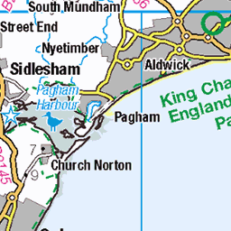
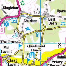
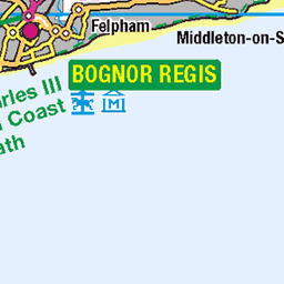
OS Map of Thorney Island
Height: 6m / 20ft • Prominence: 6m / 20ft • Trip reports (hill-bagging)

Boats
13-Apr-24 • CoasterMadMatt • flickr
sandypoint2024 sandypoint shinglebeach shinglebeaches pebblebeach pebblebeaches shingle pebble beach beaches shore shoreline thesea sea ocean englishchannel yacht yachts boat boats ship ships southhayling south hayling town towns hampshire hants southeastengland southeast england britain greatbritain gb unitedkingdom uk europe april2024 spring2024 april spring 2024 nikond3500 photo photos photographs photography coastermadmattphotography coastermadmatt 53681996559

Thorney Island-17
25-Mar-23 • Paul Dykes • flickr
thorneyisland england greatbritain unitedkingdom uk westsussex chichesterharbour coast sea 52771154700

Thorney Island-18
25-Mar-23 • Paul Dykes • flickr
thorneyisland england greatbritain unitedkingdom uk westsussex chichesterharbour coast sea 52770998789

Thorney Island-19
25-Mar-23 • Paul Dykes • flickr
thorneyisland england greatbritain unitedkingdom uk westsussex chichesterharbour coast sea 52771154140

Thorney Island-20
25-Mar-23 • Paul Dykes • flickr
thorneyisland england greatbritain unitedkingdom uk westsussex chichesterharbour coast sea 52771153975

Thorney Island-21
25-Mar-23 • Paul Dykes • flickr
thorneyisland england greatbritain unitedkingdom uk westsussex chichesterharbour coast sea 52771230278
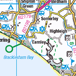
OS Map
This is OS mapping. In some areas, OpenStreetMap shows more footpaths
Spatial NI has online OSNI mapping. Click "Basemap Gallery" (4 squares icon at the top).
Now would be a good time for a cup of tea.


GPX Editor
Record map clicks
Reload map
Photos
Please tag your photos and upload them to the British and Irish Mountains group on Flickr
The other photos have been geo-tagged as on or around the summit. For less busy mountains, it can be a little hit and miss.
Boats
13-Apr-24 • CoasterMadMatt • flickr
sandypoint2024 sandypoint shinglebeach shinglebeaches pebblebeach pebblebeaches shingle pebble beach beaches shore shoreline thesea sea ocean englishchannel yacht yachts boat boats ship ships southhayling south hayling town towns hampshire hants southeastengland southeast england britain greatbritain gb unitedkingdom uk europe april2024 spring2024 april spring 2024 nikond3500 photo photos photographs photography coastermadmattphotography coastermadmatt 53681996559
Thorney Island-17
25-Mar-23 • Paul Dykes • flickr
thorneyisland england greatbritain unitedkingdom uk westsussex chichesterharbour coast sea 52771154700
Thorney Island-18
25-Mar-23 • Paul Dykes • flickr
thorneyisland england greatbritain unitedkingdom uk westsussex chichesterharbour coast sea 52770998789
Thorney Island-19
25-Mar-23 • Paul Dykes • flickr
thorneyisland england greatbritain unitedkingdom uk westsussex chichesterharbour coast sea 52771154140
Thorney Island-20
25-Mar-23 • Paul Dykes • flickr
thorneyisland england greatbritain unitedkingdom uk westsussex chichesterharbour coast sea 52771153975
Thorney Island-21
25-Mar-23 • Paul Dykes • flickr
thorneyisland england greatbritain unitedkingdom uk westsussex chichesterharbour coast sea 52771230278

Jetty | Thorney Island-25
25-Mar-23 • Paul Dykes • flickr
thorneyisland england greatbritain unitedkingdom uk westsussex chichesterharbour coast sea 52770205217

Jetty | Thorney Island-26
25-Mar-23 • Paul Dykes • flickr
thorneyisland england greatbritain unitedkingdom uk westsussex chichesterharbour coast sea 52770205017

Thorney Island-27
25-Mar-23 • Paul Dykes • flickr
thorneyisland england greatbritain unitedkingdom uk westsussex chichesterharbour coast sea 52770997059

Dunes | Pilsey Sand | Thorney Island-28
25-Mar-23 • Paul Dykes • flickr
thorneyisland england greatbritain unitedkingdom uk westsussex chichesterharbour coast sea 52770996714

19111 Thorney Island
Parked in Prinsted then walked along the gated coastal footpath to the church and then was chased off the grass near the runway by an army tracked vehicle. Name: Thorney Island Hill number: 19111 Height: 6m / 20ft Parent (Ma): none Section: 42: South-East England & the Isle of Wight County/UA: West Sussex (CoU) Island: Non Tump island Maritime Area: Hants & Dorset - Portsmouth & Wight Class: SIB Grid ref: SU765019 (est) Drop: 6m Col: Sea Comments: Benchmark on church at SU769024 indicates a height of c5.7m. So ground in vicinity of church may be an alternative summit
07-Sep-16 • Dugswell2 • flickr
thorneyisland sib p6 29652401552
Videos
Aerial view of Thorney Island runway from the southern part of the island. Can see a glimpse of Chichester Harbour on the ...
Tanya and Ash run the Thorney Island 15k, 14th May 2022.
This video shows an unsuccessful attempt at catching a fish while a Marsh harrier looks on in the background.
Thorney Island trail run 15k As you can see the weather was ideal, dry, sunny and relatively hot. No real wind either. It's very ...
Notes
- Data: Database of British and Irish Hills v18.2
- Maps: We use OS mapping for England, Scotland, Wales, and the Isle of Man. Sadly, Channel Islands, Northern (OSNI) and Southern Ireland (OSI) mapping isn't available online, so we use Openstreetmap.