Hills of Britain and Ireland
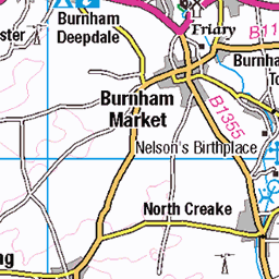
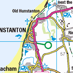
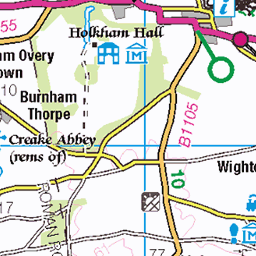
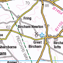
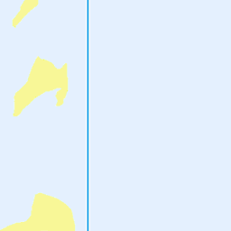
OS Map of Scolt Head Island
Height: 7m / 23ft • Prominence: 7m / 23ft • Summit : grassed-over sand dune • Trip reports (hill-bagging)

Aerial image: Burnham Deepdale & Brancaster Staithe
Aerial image: Burnham Deepdale & Brancaster Staithe in North Norfolk. The bright ball in the centre is a reflection of the Sun. #BrancasterStaithe #BurnhamDeepdale #aerial #image #Norfolk #coast #aerialphotography Burnham Deepdale aerial image
17-Aug-24 • John D Fielding • flickr
burnhamdeepdale aerial image norfolk coast coastal coastline seaside saltmarsh sssi burnham aerialimages above arial areal nikon d850 hires highresolution hirez highdefinition hidef britainfromtheair britainfromabove skyview aerialimage aerialphotography aerialimagesuk aerialview viewfromplane aerialengland britain johnfieldingaerialimages fullformat johnfieldingaerialimage johnfielding fromtheair fromthesky flyingover fullframe cidessus antenne hauterésolution hautedéfinition vueaérienne imageaérienne photographieaérienne drone vuedavion delair birdseyeview british english images pic pics view views hángkōngyǐngxiàng kōkūshashin luftbild imagenaérea imagen aérea photo photograph aerialimagery 53944225828


Scolt Head Island National Nature Reserve aerial image - Norfolk UK
Aerial view of the Scolt Head Island National Nature Reserve in the Norfolk Area of Outstanding National Beauty - Norfolk AONB aerial image
31-Jul-20 • John D Fielding • flickr
above coast highresolution nikon image britain norfolk aerialview aerial hires coastal highdefinition coastline marsh aerialphotography skyview hidef aonb viewfromplane hirez fullformat aerialimage aerialimages scolt scoltheadisland britainfromabove britainfromtheair aerialimagesuk aerialengland johnfieldingaerialimages johnfieldingaerialimage english view pics pic images views british fullframe antenne birdseyeview fromtheair imagen flyingover creeks aérea luftbild drone fromthesky delair vuedavion vueaérienne hauterésolution photographieaérienne johnfielding cidessus nortoncreek hautedéfinition imagenaérea imageaérienne hángkōngyǐngxiàng kōkūshashin butchersbeach 50361043347

Scolt Head Island aerial image - north Norfolk UK coast
aerial view of Scolt Head Island in the North Norfolk Coast Site of Special Scientific Interest - Norfolk UK coast aerial image
31-Jul-20 • John D Fielding • flickr
scolthead aerial image norfolk coast coastal coastline scoltheadisland sssi naturereserve tidal wildlifereserve eastanglia aerialimages above nikon hires highresolution hirez highdefinition hidef britainfromtheair britainfromabove skyview aerialimage aerialphotography aerialimagesuk aerialview viewfromplane aerialengland britain johnfieldingaerialimages fullformat johnfieldingaerialimage johnfielding fromtheair fromthesky flyingover fullframe cidessus antenne hauterésolution hautedéfinition vueaérienne imageaérienne photographieaérienne drone vuedavion delair birdseyeview british english images pic pics view views hángkōngyǐngxiàng kōkūshashin luftbild imagenaérea imagen aérea photo photograph 50971061437

Brancaster Harbour aerial image
aerial view of Brancaster Harbour and Scolt Head Island National Nature Reserve in north Norfolk
31-Jul-20 • John D Fielding • flickr
beach coast image norfolk aerial coastal brancaster brancasterharbour above seaside highresolution nikon hires naturereserve coastline hirez aerialimages highdefinition skyview hidef aerialimage britainfromabove britainfromtheair britain aerialview aerialphotography viewfromplane aerialimagesuk aerialengland fullformat johnfielding johnfieldingaerialimages johnfieldingaerialimage fullframe antenne fromtheair flyingover fromthesky vueaérienne hauterésolution cidessus hautedéfinition english pic images british birdseyeview drone delair vuedavion photographieaérienne imageaérienne view pics views imagen aérea luftbild imagenaérea hángkōngyǐngxiàng kōkūshashin 50771493291

Brancaster Staithe aerial image - North Norfolk coast
aerial view at Brancaster Staithe on the coast of North Norfolk - UK aerial image
20-Jul-20 • John D Fielding • flickr
brancaster aerial image norfolk tidal northnorfolk coast coastline coastal aerialimages above nikon hires highresolution hirez highdefinition hidef britainfromtheair britainfromabove skyview aerialimage aerialphotography aerialimagesuk aerialview viewfromplane aerialengland britain johnfieldingaerialimages fullformat johnfieldingaerialimage johnfielding fromtheair fromthesky flyingover fullframe cidessus antenne hauterésolution hautedéfinition vueaérienne imageaérienne photographieaérienne drone vuedavion delair birdseyeview british english images pic pics view views hángkōngyǐngxiàng kōkūshashin luftbild imagenaérea imagen aérea photo photograph 50960608037
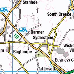
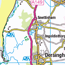
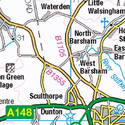
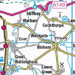
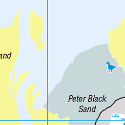
OS Map
This is OS mapping. In some areas, OpenStreetMap shows more footpaths
Spatial NI has online OSNI mapping. Click "Basemap Gallery" (4 squares icon at the top).
Now would be a good time for a cup of tea.


GPX Editor
Record map clicks
Reload map
Photos
Please tag your photos and upload them to the British and Irish Mountains group on Flickr
The other photos have been geo-tagged as on or around the summit. For less busy mountains, it can be a little hit and miss.
Aerial image: Burnham Deepdale & Brancaster Staithe
Aerial image: Burnham Deepdale & Brancaster Staithe in North Norfolk. The bright ball in the centre is a reflection of the Sun. #BrancasterStaithe #BurnhamDeepdale #aerial #image #Norfolk #coast #aerialphotography Burnham Deepdale aerial image
17-Aug-24 • John D Fielding • flickr
burnhamdeepdale aerial image norfolk coast coastal coastline seaside saltmarsh sssi burnham aerialimages above arial areal nikon d850 hires highresolution hirez highdefinition hidef britainfromtheair britainfromabove skyview aerialimage aerialphotography aerialimagesuk aerialview viewfromplane aerialengland britain johnfieldingaerialimages fullformat johnfieldingaerialimage johnfielding fromtheair fromthesky flyingover fullframe cidessus antenne hauterésolution hautedéfinition vueaérienne imageaérienne photographieaérienne drone vuedavion delair birdseyeview british english images pic pics view views hángkōngyǐngxiàng kōkūshashin luftbild imagenaérea imagen aérea photo photograph aerialimagery 53944225828
Scolt Head Island National Nature Reserve aerial image - Norfolk UK
Aerial view of the Scolt Head Island National Nature Reserve in the Norfolk Area of Outstanding National Beauty - Norfolk AONB aerial image
31-Jul-20 • John D Fielding • flickr
above coast highresolution nikon image britain norfolk aerialview aerial hires coastal highdefinition coastline marsh aerialphotography skyview hidef aonb viewfromplane hirez fullformat aerialimage aerialimages scolt scoltheadisland britainfromabove britainfromtheair aerialimagesuk aerialengland johnfieldingaerialimages johnfieldingaerialimage english view pics pic images views british fullframe antenne birdseyeview fromtheair imagen flyingover creeks aérea luftbild drone fromthesky delair vuedavion vueaérienne hauterésolution photographieaérienne johnfielding cidessus nortoncreek hautedéfinition imagenaérea imageaérienne hángkōngyǐngxiàng kōkūshashin butchersbeach 50361043347
Scolt Head Island aerial image - north Norfolk UK coast
aerial view of Scolt Head Island in the North Norfolk Coast Site of Special Scientific Interest - Norfolk UK coast aerial image
31-Jul-20 • John D Fielding • flickr
scolthead aerial image norfolk coast coastal coastline scoltheadisland sssi naturereserve tidal wildlifereserve eastanglia aerialimages above nikon hires highresolution hirez highdefinition hidef britainfromtheair britainfromabove skyview aerialimage aerialphotography aerialimagesuk aerialview viewfromplane aerialengland britain johnfieldingaerialimages fullformat johnfieldingaerialimage johnfielding fromtheair fromthesky flyingover fullframe cidessus antenne hauterésolution hautedéfinition vueaérienne imageaérienne photographieaérienne drone vuedavion delair birdseyeview british english images pic pics view views hángkōngyǐngxiàng kōkūshashin luftbild imagenaérea imagen aérea photo photograph 50971061437
Brancaster Harbour aerial image
aerial view of Brancaster Harbour and Scolt Head Island National Nature Reserve in north Norfolk
31-Jul-20 • John D Fielding • flickr
beach coast image norfolk aerial coastal brancaster brancasterharbour above seaside highresolution nikon hires naturereserve coastline hirez aerialimages highdefinition skyview hidef aerialimage britainfromabove britainfromtheair britain aerialview aerialphotography viewfromplane aerialimagesuk aerialengland fullformat johnfielding johnfieldingaerialimages johnfieldingaerialimage fullframe antenne fromtheair flyingover fromthesky vueaérienne hauterésolution cidessus hautedéfinition english pic images british birdseyeview drone delair vuedavion photographieaérienne imageaérienne view pics views imagen aérea luftbild imagenaérea hángkōngyǐngxiàng kōkūshashin 50771493291
Brancaster Staithe aerial image - North Norfolk coast
aerial view at Brancaster Staithe on the coast of North Norfolk - UK aerial image
20-Jul-20 • John D Fielding • flickr
brancaster aerial image norfolk tidal northnorfolk coast coastline coastal aerialimages above nikon hires highresolution hirez highdefinition hidef britainfromtheair britainfromabove skyview aerialimage aerialphotography aerialimagesuk aerialview viewfromplane aerialengland britain johnfieldingaerialimages fullformat johnfieldingaerialimage johnfielding fromtheair fromthesky flyingover fullframe cidessus antenne hauterésolution hautedéfinition vueaérienne imageaérienne photographieaérienne drone vuedavion delair birdseyeview british english images pic pics view views hángkōngyǐngxiàng kōkūshashin luftbild imagenaérea imagen aérea photo photograph 50960608037


18NOR212 Thistle, between Burnham Deepdale and Burnham Overy Staithe
25-Sep-18 • bentolley1 • flickr
england norfolk plant flower 45477632681

18NOR214 Frog, near Burnham Deepdale
25-Sep-18 • bentolley1 • flickr
england norfolk animal amphibian 30560859037

The Main Hut on Scolt Head - North Norfolk aerial
The Main Hut - Scolt Head Island in North Norfolk - UK aerial
10-Jun-18 • John D Fielding • flickr
scolthead norfolk northnorfolk themainhut nationalnaturereserve nationaltrust dynamicoffshorebarrierisland dunes coast coastal coastline offshorebarrierisland above aerial nikon d810 hires highresolution hirez highdefinition hidef britainfromtheair britainfromabove skyview aerialimage aerialphotography aerialimagesuk aerialview drone viewfromplane aerialengland britain johnfieldingaerialimages fullformat johnfieldingaerialimage johnfielding fromtheair fromthesky flyingover fullframe aerialimages john fielding 32309284858

19095 Scolt Head Island
Followed the path before low tide, still up to my shorts for two of the crossings then path to lovely hut before up to summit on a wet Saturday afternoon. I noticed 3 people off exploring the far western edge of the island before I headed for the summit. Name:Scolt Head Island Hill number:19095 Height:7m / 23ft Parent (Ma):none Section:39: Central and Eastern England County/UA:Norfolk (CoU) Island:Non Tump island Maritime Area:East Anglia coast Class:SIB Grid ref:TF 80870 46653 Summit feature:grassed-over sand dune Drop:7m Col:Sea
03-Sep-16 • Dugswell2 • flickr
scoltheadisland sib p7 29636094126

Videos
I'm out on my Zodiac SIB around Brancaster Staithe harbour foraging samphire. Ya gotta get it while it's about.
Burnham Overy Staithe Mill constructed in 1816. In the early 20th century it was converted in to holiday accommodation.
Early morning shots before the wind got up a little.
A quick look at the peaceful and beautiful sandy beach backed by grassy dunes at Burnham Overy Staithe on the North Norfolk ...
Notes
- Data: Database of British and Irish Hills v18.2
- Maps: We use OS mapping for England, Scotland, Wales, and the Isle of Man. Sadly, Channel Islands, Northern (OSNI) and Southern Ireland (OSI) mapping isn't available online, so we use Openstreetmap.