Hills of Britain and Ireland
Map of Herm
Height: 66m / 217ft • Prominence: 66m / 217ft • Summit : pile of large boulders E of track in pinewood • Trip reports (hill-bagging)

Fisherman's Friend
Looking out across the lovely Fisherman's Beach on Herm Island, one of the Channel Islands.
hermisland 53989433198

Shelling Out
The aptly named Shell Beach on the north east corner of Herm Island, one of the Channel Islands.
hermisland 53989625480

Clear Outlook
Looking out from near the tiny harbour on Herm Island, one of the Channel Islands. With the nearest water to me being the murky brown River Thames, courtesy in a large way to the privatised water company, it was lovely to see water a proper greeny-blue colour and as clear as anything when one looks into it.
hermisland 53988358182

Offloading
Passengers with their shopping alight from the mid afternoon ferry from St Peter Port, after docking at Rosaire Steps on Herm Island. The line of passengers on the left wait patiently before boarding for the 15.35 sailing back to Guernsey's main town.
hermisland 53989680190
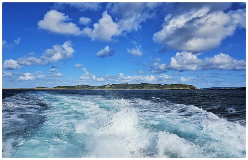
Sailing Away
Looking back to the delightful Herm Island, as seen from the rear of the mid afternoon sailing to St Peter Port, Guernsey.
hermisland 53989572609

Open Street Map
This is Open Street Map mapping. Sorry, (topographic) OSNI/Channel Islands/OSI mapping is not available online
Spatial NI has online OSNI mapping. Click "Basemap Gallery" (4 squares icon at the top).
Now would be a good time for a cup of tea.


GPX Editor
Record map clicks
Reload map
Photos
Please tag your photos and upload them to the British and Irish Mountains group on Flickr
The other photos have been geo-tagged as on or around the summit. For less busy mountains, it can be a little hit and miss.
Fisherman's Friend
Looking out across the lovely Fisherman's Beach on Herm Island, one of the Channel Islands.
hermisland 53989433198
Shelling Out
The aptly named Shell Beach on the north east corner of Herm Island, one of the Channel Islands.
hermisland 53989625480
Clear Outlook
Looking out from near the tiny harbour on Herm Island, one of the Channel Islands. With the nearest water to me being the murky brown River Thames, courtesy in a large way to the privatised water company, it was lovely to see water a proper greeny-blue colour and as clear as anything when one looks into it.
hermisland 53988358182
Offloading
Passengers with their shopping alight from the mid afternoon ferry from St Peter Port, after docking at Rosaire Steps on Herm Island. The line of passengers on the left wait patiently before boarding for the 15.35 sailing back to Guernsey's main town.
hermisland 53989680190
Sailing Away
Looking back to the delightful Herm Island, as seen from the rear of the mid afternoon sailing to St Peter Port, Guernsey.
hermisland 53989572609


A good haul
auk atlanticpuffin water islandspuffintour liquid fluid bird beak lake saintpeterport guernsey 54186891440

The odd one out
seabird azure animalmigration beak bedrock cloud bird sky islandspuffintour water nature coastalandoceaniclandforms bodyofwater saintpeterport guernsey 54149125081

18955 Herm
Out on the 08:30 boat to save £2.00 then back on the 10:35 after visiting summit rock and windmill. Name:Herm Hill number:18955 Height:66m / 217ft Parent (Ma):none Section:57: Channel Islands County/UA:Bailiwick of Guernsey Island:Channel Islands (incl. Alderney) Class:Tump (0-99m) Grid ref:WV399796 (est) Drop:66m Col:Sea
10-Jul-17 • Dugswell2 • flickr
herm bailiwickofguernsey p66 tump 35125867693


Videos
herm #channelislands #guernsey Herm is one of the Channel Islands and part of the Parish of St Peter Port in the Bailiwick of ...
In a bit of a detour from the usual mundane boatwork... I hop on an Avon SeaSport to enjoy a blast across to Guernsey's nearest ...
The beautiful Shell Beach in the north of the Channel Island of Herm. Most visitors will agree that Herm Island is a magical place.
Walking from the top of the hill on Herm Island down to the harbour on 9th October 2022. This goes from about 62 meters (203 ...
Channel Islands - explore a paradise - the island of Herm! A Herm island guide: In this video you will join us on a day trip to the ...
Notes
- Data: Database of British and Irish Hills v18.2
- Maps: We use OS mapping for England, Scotland, Wales, and the Isle of Man. Sadly, Channel Islands, Northern (OSNI) and Southern Ireland (OSI) mapping isn't available online, so we use Openstreetmap.