Hills of Britain and Ireland
OS Map of Chapelgill Hill
Height: 698m / 2290ft • Prominence: 109m / 358ft • Summit : ground 7m NW of cairn • Trip reports (hill-bagging)
Culter Fell
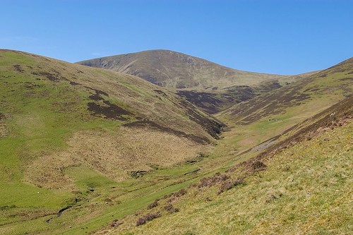
Culter Fell (2,454 feet) ( www.flickr.com/photos/67668518@N08/9503954833/in/photostream/ www.flickr.com/photos/67668518@N08/9503954833/in/photostr... ) is the highest point in the South Lanarkshire region of southern Scotland and it belongs to a range of hills that are referred to as the Culter Hills. These hills are situated to the south of the Biggar Water and lie sandwiched between the upper Clyde Valley to the west and the River Tweed to the east. The southern boundary of the Culter Hills is defined by the M74 motorway, as it crosses the watershed between the Annan and the Clyde valleys. The motorway here runs through the gap that lies between the Culter Hills and the Lowther Hills ( www.flickr.com/photos/67668518@N08/8612043366/in/set-72157632759122808/ www.flickr.com/photos/67668518@N08/8612043366/in/set-7215... ). Culter Fell conforms to the general stereotype of the Culter Hills. It is a steep-sided hill of grass and heather, with a gently rounded summit. Strictly speaking it is not an isolated hill but rather the highest point of a broad, undulating ridge that runs in a north-south direction between Scawdmans Hill and Wills Cleuch Head. This ridge marks the main east-west watershed of southern Scotland. The streams that run eastwards from Culter Fell enter the Holms Water, a tributary of the River Tweed, and those that run westwards enter the Culter Water, a tributary of the River Clyde. The name “Culter” (pronounced “Cooter”) probably only dates back to the mid-18th century and is a misspelling of “Coulter”, meaning the “fore-iron of a plough share”; possibly with reference to the shape of the fell. On late 16th century maps the hill is referred to as “Filfell”, which Peter Drummond in his book on Scottish hill names interprets to be a misspelling of “Fiends Fell”. Culter Fell is an easy hill to climb. Perhaps the best route starts from Glenkirk, in the valley of the Holms Water to the east. A 9 mile circuit around the head of the Holms Water can be made, taking in Chapelgill Hill, Culter Fell, Gathersnow Hill and Coomb Hill. On a fine day the views extend northwards from Culter Fell to the Perthshire Highlands and southwards to the hills of the English Lake District. The Manor Hills and the Moffat Hills are arrayed along the horizon to the east and Tinto ( www.flickr.com/photos/67668518@N08/9510817875/in/photostream/ www.flickr.com/photos/67668518@N08/9510817875/in/photostr... ) can be seen to the west, with the Firth of Clyde beyond. The picture was taken looking westwards up the valley of the Hope Burn towards Culter Fell from the lower slopes of Chapelgill Hill above Glenkirk Farm.
28-Apr-13 • Tony Garofalo • flickr
mountain marilyn rural walking landscape outdoors scotland riverclyde countryside pentax hiking hill scenic donald graham hillwalking rivertweed scottishborders southernuplands southlanarkshire culterfell chapelgillhill hillshawhead culterhills newdonald culters holmswater hopeburnglenkirk 9506741768

Culter Fell
Culter Fell (2,454 feet) ( www.flickr.com/photos/67668518@N08/9506741768/in/photostream/ www.flickr.com/photos/67668518@N08/9506741768/in/photostr... ) is the highest point in the South Lanarkshire region of southern Scotland and it belongs to a range of hills that are referred to as the Culter Hills. These hills are situated to the south of the Biggar Water and lie sandwiched between the upper Clyde Valley to the west and the River Tweed to the east. The southern boundary of the Culter Hills is defined by the M74 motorway, as it crosses the watershed between the Annan and the Clyde valleys. The motorway here runs through the gap that lies between the Culter Hills and the Lowther Hills ( www.flickr.com/photos/67668518@N08/8612043366/in/set-72157632759122808/ www.flickr.com/photos/67668518@N08/8612043366/in/set-7215... ). Culter Fell conforms to the general stereotype of the Culter Hills. It is a steep-sided hill of grass and heather, with a gently rounded summit. Strictly speaking it is not an isolated hill but rather the highest point of a broad, undulating ridge that runs in a north-south direction between Scawdmans Hill and Wills Cleuch Head. This ridge marks the main east-west watershed of southern Scotland. The streams that run eastwards from Culter Fell enter the Holms Water, a tributary of the River Tweed, and those that run westwards enter the Culter Water, a tributary of the River Clyde. The name “Culter” (pronounced “Cooter”) probably only dates back to the mid-18th century and is a misspelling of “Coulter”, meaning the “fore-iron of a plough share”; possibly with reference to the shape of the fell. On late 16th century maps the hill is referred to as “Filfell”, which Peter Drummond in his book on Scottish hill names interprets to be a misspelling of “Fiends Fell”. Culter Fell is an easy hill to climb. Perhaps the best route starts from Glenkirk, in the valley of the Holms Water to the east. A 9 mile circuit around the head of the Holms Water can be made, taking in Chapelgill Hill, Culter Fell, Gathersnow Hill and Coomb Hill. On a fine day the views extend northwards from Culter Fell to the Perthshire Highlands and southwards to the hills of the English Lake District. The Manor Hills and the Moffat Hills are arrayed along the horizon to the east and Tinto ( www.flickr.com/photos/67668518@N08/9510817875/in/photostream/ www.flickr.com/photos/67668518@N08/9510817875/in/photostr... ) can be seen to the west, with the Firth of Clyde beyond. The picture was taken looking northwards towards Culter Fell from Hillshaw Head
15-Jan-12 • Tony Garofalo • flickr
mountain marilyn rural walking landscape outdoors scotland riverclyde countryside pentax hiking hill scenic donald graham hillwalking rivertweed scottishborders southernuplands southlanarkshire culterfell chapelgillhill hillshawhead culterhills newdonald culters holmswater hopeburnglenkirk 9503954833

Sunset over the Southern Highlands
Taken from Chapelgill Hill, Peeblesshire. Ben Ledi is centre of shot, with Ben More and Stobinian (above the TV mast) a bit to the left of centre. Farther left still you come to Cruach Ardrain and An Caisteal. To the right of Ben Ledi is Beinn Heasgarnich.
07-Jul-96 • Graham Maxwell • flickr
sunset mountains scotland scottish hills borders campsies lanarkshire benledi benmore culter peeblesshire cruachardrain ancaisteal beinnheasgarnich chapelgillhill stobbinniein stobininan 5988055526
OS Map
This is OS mapping. In some areas, OpenStreetMap shows more footpaths
Spatial NI has online OSNI mapping. Click "Basemap Gallery" (4 squares icon at the top).
Now would be a good time for a cup of tea.
GPX Editor
Record map clicks
Reload map
Photos
Please tag your photos and upload them to the British and Irish Mountains group on Flickr
The other photos have been geo-tagged as on or around the summit. For less busy mountains, it can be a little hit and miss.
Culter Fell
Culter Fell (2,454 feet) ( www.flickr.com/photos/67668518@N08/9503954833/in/photostream/ www.flickr.com/photos/67668518@N08/9503954833/in/photostr... ) is the highest point in the South Lanarkshire region of southern Scotland and it belongs to a range of hills that are referred to as the Culter Hills. These hills are situated to the south of the Biggar Water and lie sandwiched between the upper Clyde Valley to the west and the River Tweed to the east. The southern boundary of the Culter Hills is defined by the M74 motorway, as it crosses the watershed between the Annan and the Clyde valleys. The motorway here runs through the gap that lies between the Culter Hills and the Lowther Hills ( www.flickr.com/photos/67668518@N08/8612043366/in/set-72157632759122808/ www.flickr.com/photos/67668518@N08/8612043366/in/set-7215... ). Culter Fell conforms to the general stereotype of the Culter Hills. It is a steep-sided hill of grass and heather, with a gently rounded summit. Strictly speaking it is not an isolated hill but rather the highest point of a broad, undulating ridge that runs in a north-south direction between Scawdmans Hill and Wills Cleuch Head. This ridge marks the main east-west watershed of southern Scotland. The streams that run eastwards from Culter Fell enter the Holms Water, a tributary of the River Tweed, and those that run westwards enter the Culter Water, a tributary of the River Clyde. The name “Culter” (pronounced “Cooter”) probably only dates back to the mid-18th century and is a misspelling of “Coulter”, meaning the “fore-iron of a plough share”; possibly with reference to the shape of the fell. On late 16th century maps the hill is referred to as “Filfell”, which Peter Drummond in his book on Scottish hill names interprets to be a misspelling of “Fiends Fell”. Culter Fell is an easy hill to climb. Perhaps the best route starts from Glenkirk, in the valley of the Holms Water to the east. A 9 mile circuit around the head of the Holms Water can be made, taking in Chapelgill Hill, Culter Fell, Gathersnow Hill and Coomb Hill. On a fine day the views extend northwards from Culter Fell to the Perthshire Highlands and southwards to the hills of the English Lake District. The Manor Hills and the Moffat Hills are arrayed along the horizon to the east and Tinto ( www.flickr.com/photos/67668518@N08/9510817875/in/photostream/ www.flickr.com/photos/67668518@N08/9510817875/in/photostr... ) can be seen to the west, with the Firth of Clyde beyond. The picture was taken looking westwards up the valley of the Hope Burn towards Culter Fell from the lower slopes of Chapelgill Hill above Glenkirk Farm.
28-Apr-13 • Tony Garofalo • flickr
mountain marilyn rural walking landscape outdoors scotland riverclyde countryside pentax hiking hill scenic donald graham hillwalking rivertweed scottishborders southernuplands southlanarkshire culterfell chapelgillhill hillshawhead culterhills newdonald culters holmswater hopeburnglenkirk 9506741768
Culter Fell
Culter Fell (2,454 feet) ( www.flickr.com/photos/67668518@N08/9506741768/in/photostream/ www.flickr.com/photos/67668518@N08/9506741768/in/photostr... ) is the highest point in the South Lanarkshire region of southern Scotland and it belongs to a range of hills that are referred to as the Culter Hills. These hills are situated to the south of the Biggar Water and lie sandwiched between the upper Clyde Valley to the west and the River Tweed to the east. The southern boundary of the Culter Hills is defined by the M74 motorway, as it crosses the watershed between the Annan and the Clyde valleys. The motorway here runs through the gap that lies between the Culter Hills and the Lowther Hills ( www.flickr.com/photos/67668518@N08/8612043366/in/set-72157632759122808/ www.flickr.com/photos/67668518@N08/8612043366/in/set-7215... ). Culter Fell conforms to the general stereotype of the Culter Hills. It is a steep-sided hill of grass and heather, with a gently rounded summit. Strictly speaking it is not an isolated hill but rather the highest point of a broad, undulating ridge that runs in a north-south direction between Scawdmans Hill and Wills Cleuch Head. This ridge marks the main east-west watershed of southern Scotland. The streams that run eastwards from Culter Fell enter the Holms Water, a tributary of the River Tweed, and those that run westwards enter the Culter Water, a tributary of the River Clyde. The name “Culter” (pronounced “Cooter”) probably only dates back to the mid-18th century and is a misspelling of “Coulter”, meaning the “fore-iron of a plough share”; possibly with reference to the shape of the fell. On late 16th century maps the hill is referred to as “Filfell”, which Peter Drummond in his book on Scottish hill names interprets to be a misspelling of “Fiends Fell”. Culter Fell is an easy hill to climb. Perhaps the best route starts from Glenkirk, in the valley of the Holms Water to the east. A 9 mile circuit around the head of the Holms Water can be made, taking in Chapelgill Hill, Culter Fell, Gathersnow Hill and Coomb Hill. On a fine day the views extend northwards from Culter Fell to the Perthshire Highlands and southwards to the hills of the English Lake District. The Manor Hills and the Moffat Hills are arrayed along the horizon to the east and Tinto ( www.flickr.com/photos/67668518@N08/9510817875/in/photostream/ www.flickr.com/photos/67668518@N08/9510817875/in/photostr... ) can be seen to the west, with the Firth of Clyde beyond. The picture was taken looking northwards towards Culter Fell from Hillshaw Head
15-Jan-12 • Tony Garofalo • flickr
mountain marilyn rural walking landscape outdoors scotland riverclyde countryside pentax hiking hill scenic donald graham hillwalking rivertweed scottishborders southernuplands southlanarkshire culterfell chapelgillhill hillshawhead culterhills newdonald culters holmswater hopeburnglenkirk 9503954833
Sunset over the Southern Highlands
Taken from Chapelgill Hill, Peeblesshire. Ben Ledi is centre of shot, with Ben More and Stobinian (above the TV mast) a bit to the left of centre. Farther left still you come to Cruach Ardrain and An Caisteal. To the right of Ben Ledi is Beinn Heasgarnich.
07-Jul-96 • Graham Maxwell • flickr
sunset mountains scotland scottish hills borders campsies lanarkshire benledi benmore culter peeblesshire cruachardrain ancaisteal beinnheasgarnich chapelgillhill stobbinniein stobininan 5988055526
Videos
We head on down to Coulter and walk from Culter Allers Farm to Chapelgill Hill and then onto Culter Fell. A good day made a bit ...
Notes
- Data: Database of British and Irish Hills v18.2
- Maps: We use OS mapping for England, Scotland, Wales, and the Isle of Man. Sadly, Channel Islands, Northern (OSNI) and Southern Ireland (OSI) mapping isn't available online, so we use Openstreetmap.